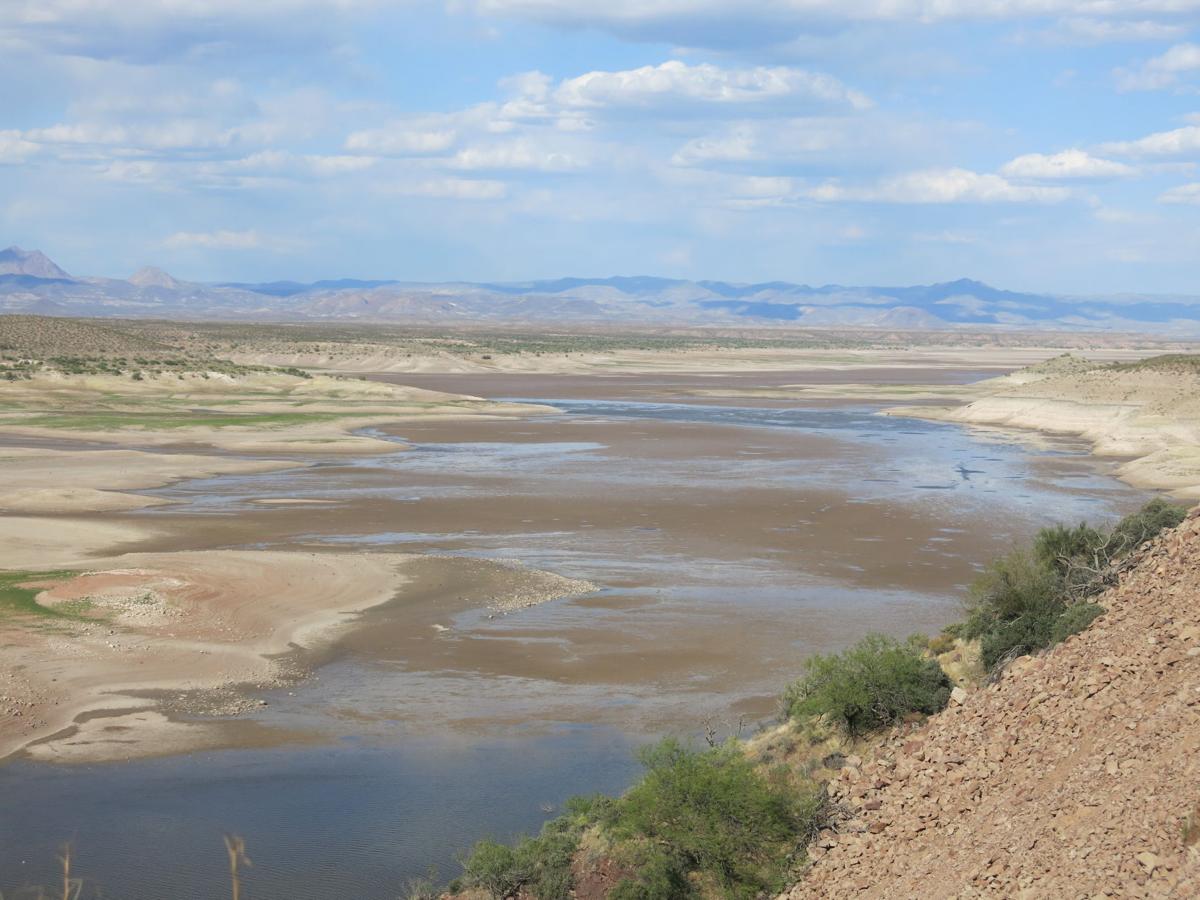
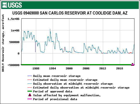
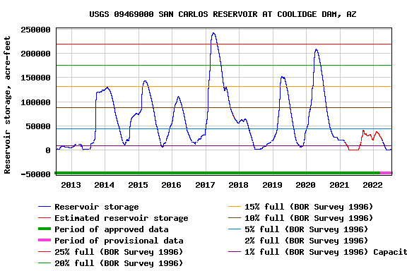
San_Carlos_Lake is located within the 3,000-square-mile (7,800 km2) San Carlos Apache Indian Reservation, and is thus subject to tribal regulations. It has been full only three times, in 1993 it overflowed the spillway and about 35,000 cfs of water caused erosion damage to natural gas pipelines. The lake contained (April 6,2021) less than 100 acre-ft of water. All fish was dead. This was also the case in 2022, thelake was emptied even earlier in the season.
When former President Coolidge dedicated the dam in 1930, the dam had not begun to fill. Humorist Will Rogers looked at the grass in the lake bed, and said, “If this were my dam, I’d mow it.”[
After the Transcontinental aqueduct will be built the lake will always be nearly filled, lake level will be at up to 2510 feet with flood control nearly automatic, it will never overflow, and it will look like this, or better:
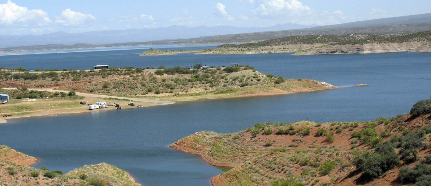
The San Carlos lake, when filled will hold 1,000,000 acre-ft of water. Here it is half filled.
The Coolidge dam will have to be retrofitted to accommodate a 17,000 cfs water flow. When water starts flowing at half capacity, 8,400 cfs in phase 1 of the building project it will take 2 months to fill the lake.
What’s in it for Arizona? The San Carlos Lake has been a great disappointment. It is more often empty than even half full, and when it is empty, all fish die. The Gila river will be rejuvenated and will be able to contain fish again, making it the great recreation spot it was meant to be. In addition it will generate up to 1,4 GW of Power and carry up to 12 Million Acre-ft per year of water to the thirsty American South-west when the aqueduct is built to full capacity. In the first phase when the power stations have installed only half capacity, the flow will be 6 MAf per year, and power generated will be up to 700 MW.
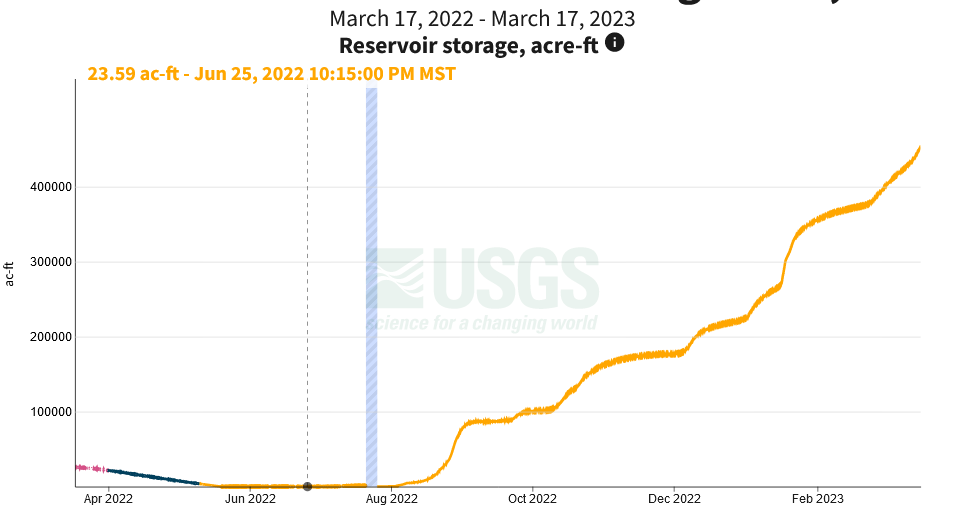
Thanks to an over abundance of rain ad snow this winter the lake is now at the highest level since 1996, at 325% of normal level, and the melting of the snow-melt in the mountains has yet to manifest itself’ This is the chart of the current year’s statistics:
Mar 17 value 452,200 Acre-ft. The first 10 years of the dam the lake was below half full. The chart from 1882 to today shows that the lake is now at the highest level since 1996.
The San Carlos Lake being half filled for the first time in 27 years will alliveate the Arizona drought, but not enough to stop draining the aquifers. With people fleeing California and resettle in Arizona the only viable solution is to build a Trans-continental aqueduct from the Arkansas River to Arizona. Check it out, it is quite interesting.
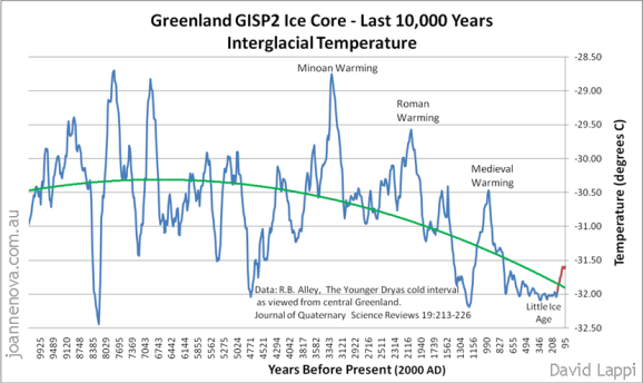
When the Supreme Court ruled that an agency such as the EPA does not have the authority to regulate CO2 emissions by fiat. Only Congress can enact a law to do this. I pointed out that CO2 is not the culprit gas that causes climate change, and as an example I used the South Pole weather station, having a 60+ year of good statistics, and it showed that the temperature trend is -2C per century. One would have expected a rise, since at the average winter temperature of -61C water vapor is nearly non-existent, and CO2 is the dominant greenhouse gas. One would have expected a one degree or more warming instead. This is one data point we are in a cooling trend,and indeed we are. The Greenland ice data shows it to be true:
Yet the current worldwide trend is a temperature increase. Note that the temperature models have increased the temperature increase with time from CIMP5 to CIMP6, and so diverging more and more from the HADCRUT4 data.
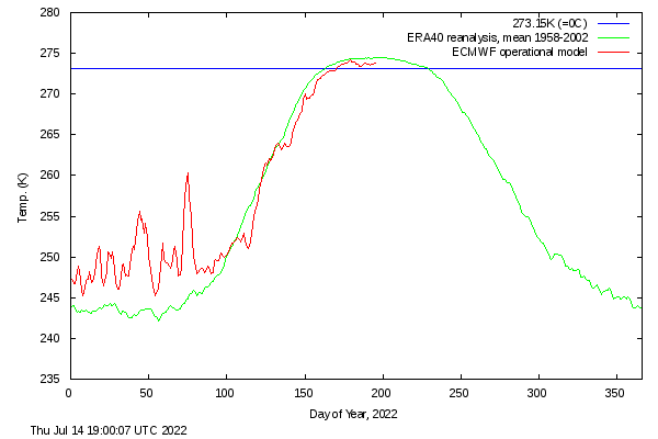
The overall worldwide temperature is increasing, but not at the rate the climate models suggest. The important thing is, where are the temperature increases? The South Pole winter temperatures are decreasing 2C per century, but summer temperatures are increasing ever so slightly. In the Arctic the situation is reversed. The winter temperatures have risen between 3C and 7C and vary widely from year to year, but the summer temperatures are slowly decreasing. The current temperature chart for the Arctic above 80 degrees latitude tells the story:
Notice the wild temperature swings in the winter, and the temperature stability below average in spring and summer.
There must be something with Climate change far more important than rising CO2 levels, and indeed there is. A couple of weeks ago I told a story of Dr Lovelock and his Gaya theory, and how he found out the air had much more DiMethylSulfide (DMS) than expected, and the molecules acted as condensation points for clouds. The DMS was generated by Phytoplankton, dinoflagellates and diatoms that contain chlorophyll and require sunlight in order to live and grow. Most phytoplankton are buoyant and float in the upper part of the ocean, where sunlight penetrates the water. Phytoplankton also require inorganic nutrients such as nitrates, phosphates, and sulfur which they convert into proteins, fats, and carbohydrates. If nutrients are too abundant it can lead to algae blooms, such as red tide. In that case all oxygen are consumed and the algae dies and leave a toxic mess. The areas where this occurs are near river outlets that contain too many nourishments. This is the case in the Mexican Gulf, the Eastern seaboard, the North Sea and the Baltic, as well as South Asia and East Asia. The inland areas will see more clouds and more rains, but not necessarily more severe storms. Flooding may increase though.
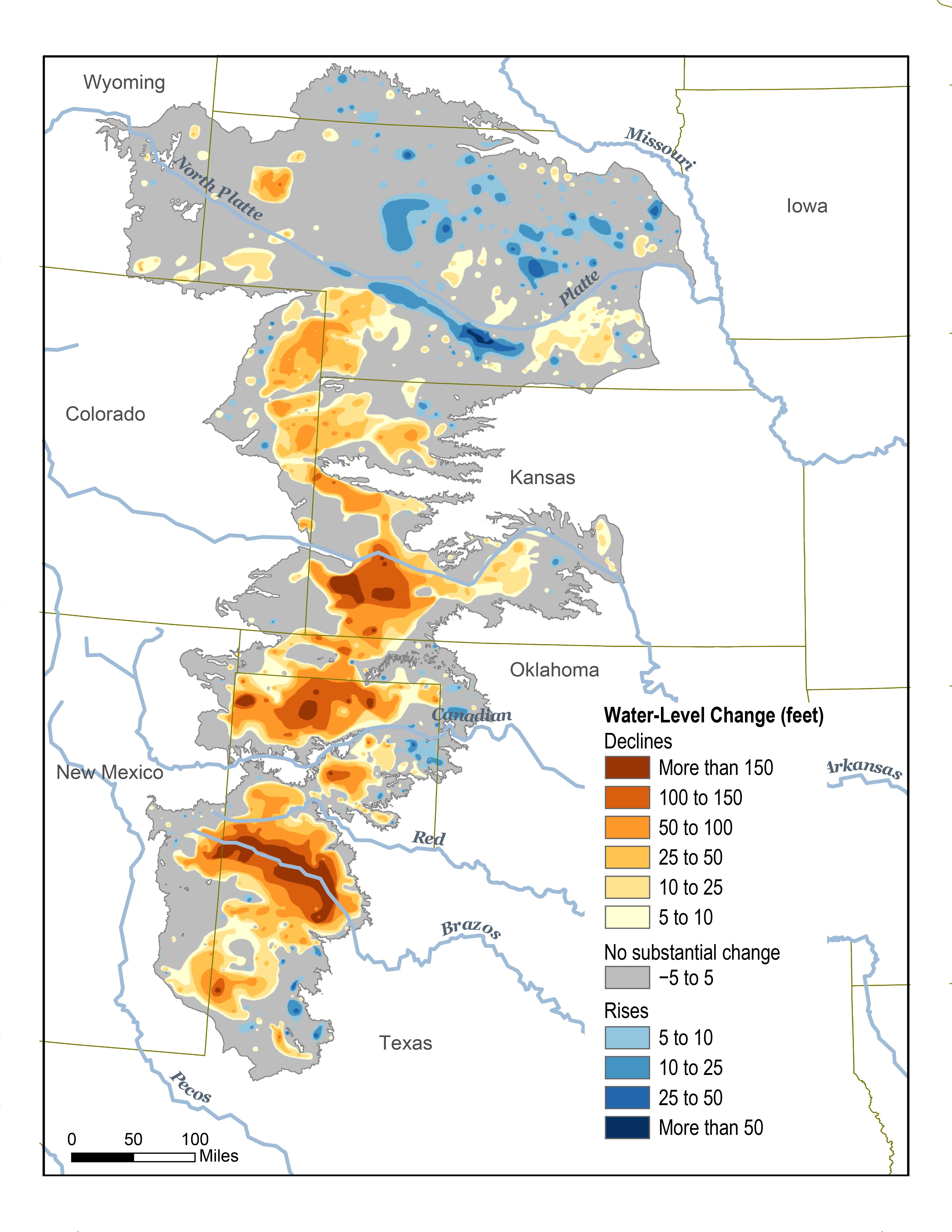
Far more troublesome is what happens to areas that do not experience an increase in clouds. The trouble starts a few hundred miles west of the Mississippi River in the Ogallala aquifer. This map shows changes in Ogallala water levels from the period before the aquifer was tapped to 2015.
Image credit: Nation Climate Assessment 2018
Going west to New Mexico things get worse. New Mexico depends on the monsoon rains starting in July and continues into the fall. They have a tendency to fail from time to time and sometimes many years in a row, they cannot be relied upon to water the thirsty earth. The grass and other vegetation dies, and when the rains come, they often cause flash floods that are very destructive to the soil, and leaves large areas barren. To illustrate what is happening take the Gila River. It starts in the Gila National Forest in New Mexico and flow through near Phoenix and ends i the Colorado River near the Mexico border. It used to have a flow of 1.3 million Acre-feet annually flowing seasonally through the Phoenix area. The Coolidge dam was built in 1930, all the land was taken by eminent domain, the Indians protested that some ancient burial grounds would be flooded, but at no avail. The dam was built, and a big disappointment it was. The evaporation from the San Carlos Lake was higher than the inflow for much of the year, co the total flow of the Gila river was greatly reduced. These are the numbers for the last ten years:
Only once in the last ten years has the lake been filled to even 25% of full capacity, and the last two years the lake has dried out during the most important growing season.All fish has died. The lake is totally useless even for recreational purposes, and nearly worthless for the Phoenix area as water supply. The Central Arizona Project has a capacity of providing 1.4 million Acre-feet a year, but has only been awarded a fraction of its capacity from the Colorado River, and since Lake Mead is drying up, the supply will be reduced to almost nothing.
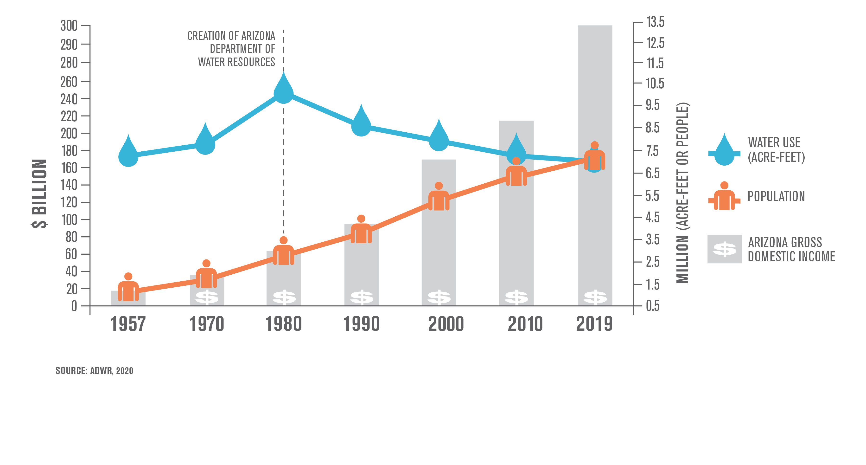
Hoe dire is the situation? Arizona has a rising population, This chart shows it well:
Arizona has had a water problem since before the creation of the Arizona department of water resources. The farmers that had water rights took their allotment and expected a low price, say $100 per acre-ft, the cost of pumping it out of the ground. The municipal users don’t mind to pay $1,500 per acre-ft, after all, that is only 2 cents per gallon, so when the supply fails, the farmer is the loser.
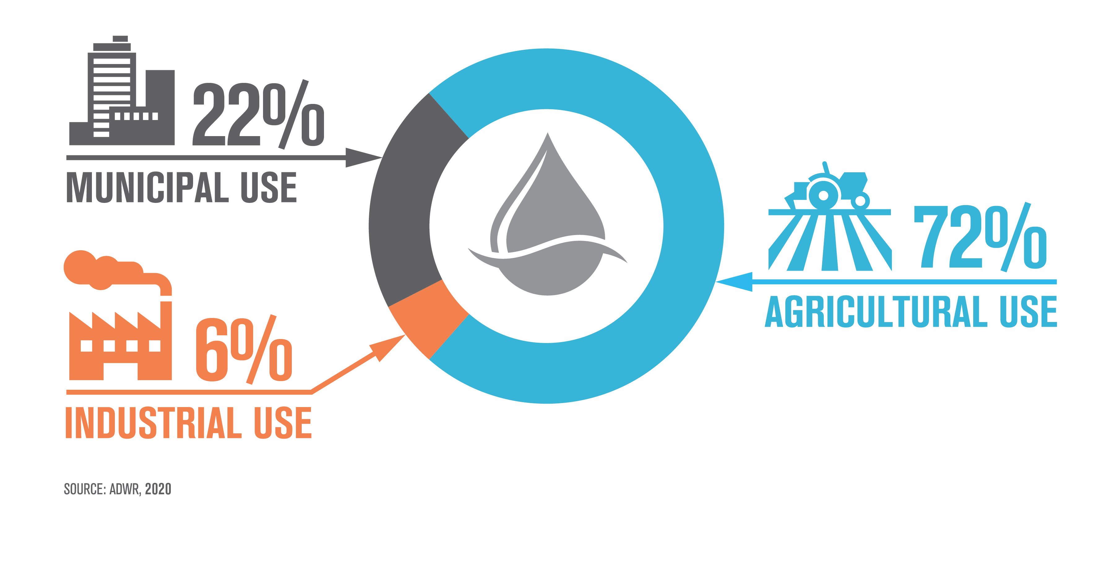
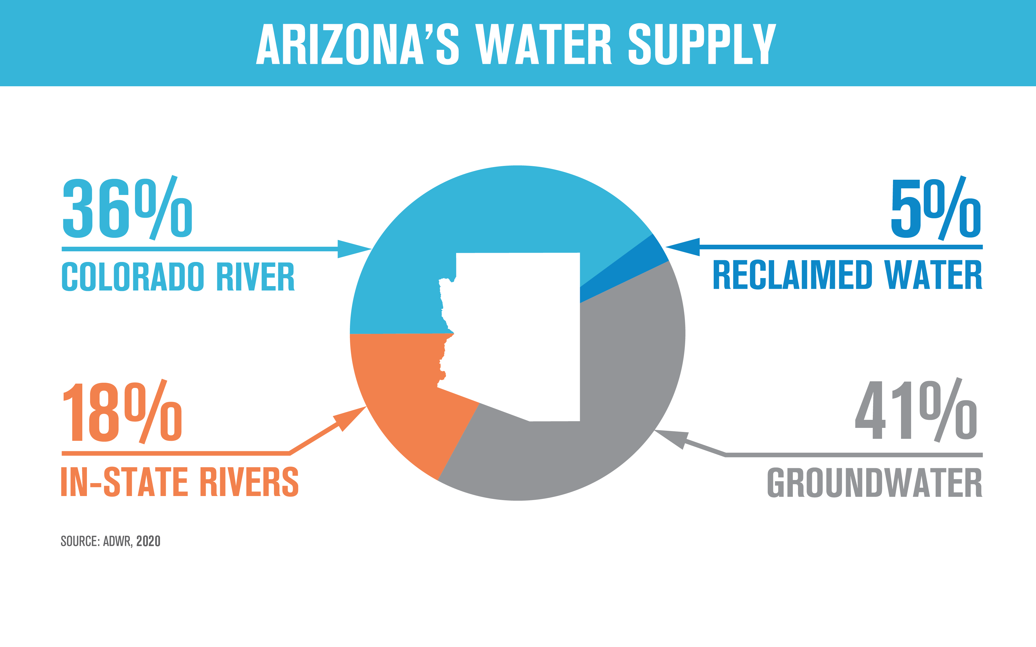
So, where do the water supplies come from? These are official numbers from 2019
Since then the situation has gotten much worse. The Colorado River contribution is down by at least 30%, and will be cut down further when Lake Mead drops some more. It is already precariously close to dead pool. The Gila River water flow is zero during growing season, but the Salt River still delivers 300,000 A-f per year, all during growing season. So the in-state river flow is down by a half. This means that over half of Arizona’s water supply will come from drawing down the aquifers. This will reduce the river flows some more, the land will be dried up, and eventually the wells will dry up and Arizona will act more like a desert, with no cooling capacity left in the soil, the summer temperatures will be even hotter and dust storms will be common. The trees will die from drought and wildfires will increase. When the monsoon rains come, heavy flash floods will remove what little top soil is left. This is real climate change in the American Southwest.
If we concentrate on limiting CO2 emissions but ignore the real causes of climate change this is the future the American South-west can look forward to. If we took a fraction of the money earmarked to eliminate fossil fuel and use it instead to save the planet, in this case the American Southwest, then we’ll again make the American Southwest livable with enough water for 40 million people, and with a still functioning agriculture in the west, supplying food for many more people, plants and wildlife.
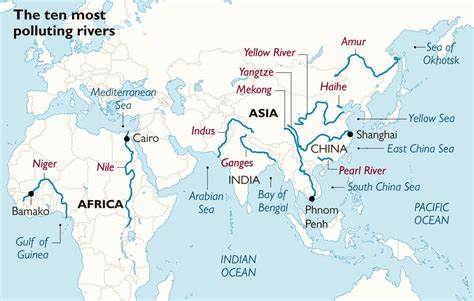
One of the problems leading to climate change is polluting rivers. Of the ten most polluting rivers in the world none are in Europe or the Americas, see map:
The main pollutant in these rivers is particle pollution such as plastic, but unprocessed sewage is prevalent.
Nitrogen pollution from agriculture is another problem, even in Europe and America. The Dutch farmers are up in arms over the draconian measures imposed by the Dutch government, praised on by Klaus Schwab and he New world Order leaders that want “The great reset”. This involves reducing the nitrogen content on the agricultural lands by 50, 75 and even 95% in certain areas, reduce cattle by 50% and a similar reduction in the pig population. The protest is joined by Germany, Poland, Italy and Spain (and maybe Australia). The protest is immense:
Government mandates cannot solve the nitrogen crisis. The best way to reduce the nitrogen pollution is to lower the nitrogen fertilizer from slightly above optimum to slightly below optimum. With fertilizer cost more than tripling this adjustment was going to be made anyhow. Plants have a remarkable ability to absorb the nitrogen, and with the rising CO2 levels they do so more efficiently. The optimum amount is different for every plot, and any farmer knows much better than any desk-bound bureaucrat how and when to sow, fertilize and reap.
In the eastern half of the U.S. water rights comes with the land, and since rainfall can lead to floods, water rights are water responsibilities. When a land owner disturbs the soil he must first put up a retaining sausage to stop erosion. Then he has to build a retainment basin to compensate for roofs and hardened surfaces, so the water will be retained on the property as much as possible. This will lessen floods. The farmers have to build shallow ditches adjacent to creeks and rivers to prevent agricultural runoffs. And fertilizing is only allowed when no thunderstorms or rains are expected
In the dry American southwest it is all about water rights. Land without water rights is nearly worthless. If a homeowner without water rights get caught putting a bucket under his downspout and uses the rain to water a newly planted thee, he can be fined. All water must be purchased. This is wrong. The water that rains on a piece of land belongs to the land and should return to the aquifer. The springs, forming creeks belong to the river and cannot be dammed. This will help restore the aquifiers, but the river flows will be diminished until the aquifers are restored, which may take a century. So before the water rights question can be righted and the aquifers restored we must
Build a TransContinental Aqueduct. This will solve the water needs for the upper Western Texas, New Mexico, Arizona, lower California, Mexico and the Lower Colorado River basin, and then
Build a Trans-Rocky Mountain aqueduct. This will solve some of the water needs for Oklahoma, Kansas, Colorado, upper New Mexico and the Upper Colorado river basin. To complete the trying to save the aquifers we also need to
Build aSouth Platte River aqueduct. This will solve the water needs for the greater Denver ares and help preserve the northern Ogallala aquifer.
The rise in CO2 is on balance positive, it has already helped to keep 2 billion people from starvation. With food famine coming the very worst thing we can do is declare a climate emergency and unilaterally reduce our electric supply eliminating much of our fossil fuel source to produce electricity and at the same time push electric cars.
Stage 11 is a true delivery of water on demand aqueduct. The San Carlos lake has a storage capacity of a million acre-ft, the ideal buffer from the peak power demand driven uphill stages to the major delivery stage. San Carlos lake is now mostly empty, but will be normally filled to 85% of capacity, slightly less in advance of the winter snow melt. The Lake would look like this:
San Carlos lake, about half full
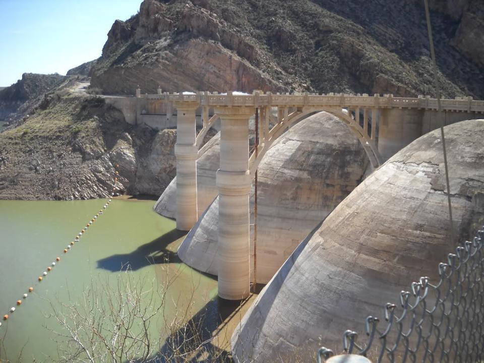
The Coolidge dam is now decommissioned, the lake is too often empty and the dam suffered damage in the power plant and it was no longer economical to produce power. The retrofitted dam will have a power generation capacity of up to 17,000 cfs the top of the dam is at 2535 ft, the typical water level is at 2500 ft and the drop is 215 feet, giving a maximum power output of 275 MW. In the first pass, the maximum output is 8,500 cfs , and the maximum power output is 135 MW.
The Coolidge dam before rebuilding.
From there the stream follows the Gila River to the East diversion dam and connects to the Tucson leg of the CAP canal, and delivers 600 cfs of water. It it then disconnected to the bottom of the canal.
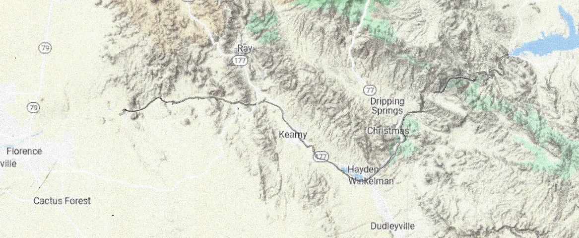
The East Diversion dam will be reinforced, and the anal capacity will be increased to 600 cfs.The free flowing Gila River with reinforcements around Hayden and the copper mine.
Whats in it for Arizona? Besides having a reliable flow, Gila river will again be good for fishing if stocked and it will deliver 600 cfs of reliable sweet Mississippi and Arkansas river water to the Tucson area. When fully built out it will deliver up to 275 MW of power.
The aqueduct stage of this leg is 32 miles and is generating power.The drop is average (4,200 – 3,000 – 32×2.2) = 1,130 feet. The maximum flow is 16,800 cfs. This stage is capable of generating maximum 1.4 GW of power 24 hours a day. Then it drains into Gila River for 47 miles, following 14 miles of San Carlos lake, for a total of 93 miles.
San_Carlos_Lake is located within the 3,000-square-mile (7,800 km2) San Carlos Apache Indian Reservation, and is thus subject to tribal regulations. It has been full only three times, in 1993 it overflowed the spillway and about 35,000 cfs of water caused erosion damage to natural gas pipelines. The lake contained (April 6,2021) less than 100 acre-ft of water. All fish was dead.
When former President Coolidge dedicated the dam in 1930, the dam had not begun to fill. Humorist Will Rogers looked at the grass in the lake bed, and said, “If this were my dam, I’d mow it.”[
When the Transcontinental aqueduct is built the lake will always be nearly filled, level will be at 2510 feet with flood control nearly automatic, it will never overflow, and it will look like this, or better:
The San Carlos lake, when filled will hold 1,000,000 acre-ft of water. Here it is half filled.
The Coolidge dam will have to be retrofitted to accommodate a 17,000 cfs water flow. When water starts flowing at half capacity, 8,400 cfs in phase 1 of the building project it will take 2 months to fill the lake.
What’s in it for Arizona? The San Carlos Lake has been a great disappointment. It is more often empty than even half full, and when it is empty, all fish die. With The Gila river will be rejuvenated and will be able to carry fish again, making it the great recreation spot it was meant to be. In addition it will generate up to 1,4 GW of Power and carry up to 12 Million Acre-ft per year of water to the thirsty American South-west. In the first phase, while the aqueduct is built to full capacity, when the power stations have installed only half capacity, the flow will be 6 MAf per year, and power generated will be up to 700 MW.
The aqueduct stage of this leg is 32 miles and is generating power.The drop is average (4,200 – 3,000 – 32×2.2) = 1,130 feet. The maximum flow is 16,800 cfs. This stage is capable of generating maximum 1.4 GW of power 24 hours a day. Then it drains into Gila River for 47 miles, following 14 miles of San Carlos lake, for a total of 93 miles.
San_Carlos_Lake is located within the 3,000-square-mile (7,800 km2) San Carlos Apache Indian Reservation, and is thus subject to tribal regulations. It has been full only three times, in 1993 it overflowed the spillway and about 35,000 cfs of water caused erosion damage to natural gas pipelines. The lake contained (April 6,2021) less than 100 acre-ft of water. All fish was dead.
When former President Coolidge dedicated the dam in 1930, the dam had not begun to fill. Humorist Will Rogers looked at the grass in the lake bed, and said, “If this were my dam, I’d mow it.”[
When the Transcontinental aqueduct is built the lake will always be nearly filled, level will be at 2510 feet with flood control nearly automatic, it will never overflow, and it will look like this, or better:
The San Carlos lake, when filled will hold 1,000,000 acre-ft of water.
The Coolidge dam will have to be retrofitted for a 25,000 cfs water flow
The Coolidge dam will have to be retrofitted for a 17,000 cfs water flow. When water starts flowing at half capacity, 8,400 cfs in phase 1 of the building project it will take 2 months to fill the lake.
What’s in it for Arizona? The San Carlos Lake has been a great disappointment. It is more often empty than even half full, and when it is empty, all fish die. With The Gila river will be rejuvenated and will be able to carry fish again, making it the great recreation spot it was meant to be. In addition it will generate up to 1,4 GW of Power and carry up to 12 Million Acre-ft per year of water to the thirsty American South-west. In the first phase, while the aqueduct is built to full capacity, the flow will be 6 MAf per year.
Stage 12 is a true delivery of water on demand aqueduct. The San Carlos lake has a storage capacity of a million acre-ft, the ideal buffer from the peak power demand driven uphill stages to the major delivery stage. San Carlos lake is now mostly empty, but will be normally filled to 85% of capacity, slightly less in advance of the winter snow melt. The Lake would look like this:
San Carlos lake, about half full
The Coolidge dam is now decommissioned, the lake is too often empty and the dam suffered damage in the power plant and it was no longer economical to produce power. The retrofitted dam will have a power generation capacity of up to 19,000 cfs the top of the dam is at 2535 ft, the typical water level is at 2500 ft and the drop is 215 feet, giving a maximum power output of 315 MW.
Coolidge dam before rebuilding
From there the stream follows the Gila River all the way to the Colorado River with the following drop-offs:
Where the Arizona central project waterway crosses the Gila river it will deliver up to 500 cfs to Tucson
Where the Gila river meets the Salt river it can deliver up to 1,500 cfs to the Phoenix-Scottsdale metropolitan area.
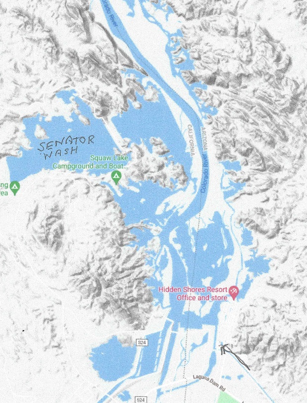
To the Martinez lake it can deliver up to 15,155 cfs, the design capacity of the All American canal. This will of course be nearly always far less, dependent on the need for water for irrigation, but we dimension the aqueduct to accommodate maximum flow. The Martinez lake is puny, and would easily be overwhelmed by surges in the water flow. To accommodate this, the Senator Wash Reservoir will have to be upgraded to be able to pump up or down at least twice as much water as is it’s present capacity. Lake Martinez is at about 180 feet elevation, and Senator Wash Reservoir is at a maximum elevation of 240 feet.
The Martinez lake and the Senator Wash Reservoir.
The rest of the Transcontinental Aqueduct empties out where the Gila river joins the remainder of the Colorado river a few miles downstream. It will be able to carry up to 6, 000 cfs of water to accommodate the needs of Mexico and also provide a modest amount of water to assure the Colorado river again reaches the ocean, maybe restoring some shrimp fishing in the ocean.
The 1944 water treaty with Mexico provides Mexico with 1.5 million acre-ft per year, more or less dependent of drought or surplus. It will be increased only on condition that when the Transcontinental aqueduct is finished, the New River in Mexicali will be cut off at the border, and Mexico will have to do their own complete waste water treatment.
There will be water allocated to the Salton Sea. Proposed will be the world’s largest Lithium mine, mining the deep brine, rich in Lithium. (about a third of the world supply according to one estimate). This requires water, and as a minimum to allow mining in the Salton Sea the water needs to be cleaned. This requires further investigation, but the area around the Salton Sea is maybe the most unhealthy in the United States.
The maximum power generating drop during this last leg will be (2500 – 190 – 2.2X 280) = 1694 feet. With an average flow of 14,000 cfs this will generate 1.8 GW of power, but the realized power output will be determined by the actual water demands.
Stage 10 was a true pumped hydro-storage peak power stage, producing up to 11.0 GW electric power for up to 5 hours a day. In stage 11 the flow will be a maximum flow of up to 25,000 cfs, but with periods of less flow during low electricity demand, all to accommodate both water needs and power demands.
The power generating drop is on average (4320 – 2510 – 80×2.2) = 1,634 feet. This stage is capable of generating maximum 2.4 GW of power during all times.
San_Carlos_Lake is located within the 3,000-square-mile (7,800 km2) San Carlos Apache Indian Reservation, and is thus subject to tribal regulations. It has been full only three times, in 1993 it overflowed the spillway and about 35,000 cfs of water caused erosion damage to natural gas pipelines. The lake contains now (April 6,2021) less than 100 acre-ft of water. All fish is dead.
When former President Coolidge dedicated the dam in 1930, the dam had not begun to fill. Humorist Will Rogers looked at the grass in the lake bed, and said, “If this were my dam, I’d mow it.”[
When the Transcontinental aqueduct is built the lake will always be nearly filled, level will be at 2510 feet with flood control nearly automatic, it will never overflow, and it will look like this:
The San Carlos lake, when filled will hold 1,000,000 acre-ft of water.
The Coolidge dam will have to be retrofitted for a 25,000 cfs water flow
Stage 12 is a true delivery of water on demand aqueduct. The San Carlos lake has a storage capacity of a million acre-ft, the ideal buffer from the peak power demand driven uphill stages to the major delivery stage. San Carlos lake is now mostly empty, but will be normally filled to 85% of capacity, slightly less in advance of the winter snow melt. The Lake would look like this:
San Carlos lake, about half full
The Coolidge dam is now decommissioned, the lake is too often empty and the dam suffered damage in the power plant and it was no longer economical to produce power. The retrofitted dam will have a power generation capacity of up to 19,000 cfs the top of the dam is at 2535 ft, the typical water level is at 2500 ft and the drop is 215 feet, giving a maximum power output of 325 MW.
Coolidge dam before rebuilding
From there the stream follows the Gila River all the way to the Colorado River with the following dropoffs:
Where the Arizona central project waterway crosses the Gila river it will deliver up to 500 cfs to Tucson
Where the Gila river meets the Salt river it can deliver up to 1,500 cfs to the Phoenix-Scottsdale metropolitan area.
To the Martinez lake it can deliver up to 15,155 cfs, the design capacity of the All American canal. This will of course be nearly always far less, dependent on the need for water for irrigation, but we dimension the aqueduct to accomodate maximum flow. The Martinez lake is puny, and would easily be overwhelmed by surges in the water flow. To accommodate this, the Senator Wash Reservoir will have to be upgraded to be able to pump up or down at least twice as much water as is it present capacity. Lake Martinez is at about 180 feet elevation, and Senator Wash Reservoir is at a maximum elevation of 240 feet.
The Martinez lake and the Senator Wash Reservoir.
The rest of the Transcontinental Aqueduct empties out where the Gila river joins the remainder of the Colorado river a few miles downstream. It will be able to carry up to 6, 000 cfs of water to accommodate the needs of Mexico and also provide a modest amount of water to assure the Colorado river again reaches the ocean, maybe restoring some shrimp fishing in the ocean.
The 1944 water treaty with Mexico provides Mexico with 1.5 million acre-ft per year, more or less dependent of drought or surplus. It will be increased only on condition that when the Transcontinental aqueduct is finished, the New River in Mexicali will be cut off at the border, and Mexico will have to do their own complete waste water treatment.
There will be water allocated to the Salton Sea. Proposed will be the world’s largest Lithium mine, mining the deep brine, rich in Lithium. (about 40% of the world supply according to one estimate). This requires water, and as a minimum to allow mining in the Salton Sea the water needs to be cleaned. This requires further investigation, but the area around the Salton Sea is maybe the most unhealthy in the United States.
The maximum power generating drop during this last leg will be (2500 – 190 – 2.2X 280) = 1694 feet. With an average flow of 14,000 cfs this will generate 1.9 GW of power, but the realized power output will be determined by the actual water demands.
Stage 10 was a true pumped hydro-storage peak power stage, producing up to 11.5 GW electric power for up to 5 hours a day. In stage 11 the flow will be a maximum flow of up to 25,000 cfs, but with periods of less flow during low electricity demand, all to accommodate both water needs and power demands.
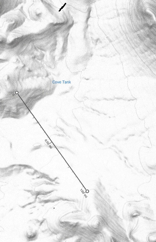
The Cove Tank Reservoir dam is 1 mile wide and 250 feet high, the top of the dam is at 4,000 feet. containing up to 60,000 acre-ft of water, enough storage for more than a day’s flow.
The Cove tank Reservoir starts out nearly empty when peak power demand starts, and is rapidly filling up until peak demand ends
The power generating drop is on average (3800 – 2535 – 70×2.2) = 1,111 feet. This stage is capable of generating maximum 2.2 GW of power during peak power demand, adjusted down at low power demand to not exceed the daily water supply.
San Carlos lake is located within the 3,000-square-mile (7,800 km2) San Carlos Apache Indian Reservation, and is thus subject to tribal regulations. It has been full only three times, in 1993 it overflowed the spillway and about 35,000 cfs of water caused erosion damage to natural gas pipelines. The lake contains now (April 6,2021) less than 100 acre-ft of water. All fish is dead.
When former President Coolidge dedicated the dam in 1930, the dam had not begun to fill. Humorist Will Rogers looked at the grass in the lake bed, and said, “If this were my dam, I’d mow it.”[
When the Transcontinental aqueduct is built the lake will always be nearly filled, with flood control nearly automatic, it will never overflow, and it will look like this:
The San Carlos lake, when filled will hold 1,000,000 acre-ft of water.
The Coolidge dam will have to be retrofitted for a 25,000 cfs water flow