Stage 3 consists of 40 miles on Lake Eufaula, 10 miles on Aquila lake and 125 miles of a 22,000 cfs aqueduct, 95 miles in Oklahoma and 30 miles in Texas. This segment should ideally have used lake Texoma, but the water in it is brackish with between one half to one percent salinity, so it is unusable for drinking water, and even for agricultural purposes.
It starts out at lake Eufaula:
Conservation pool elevation 585′
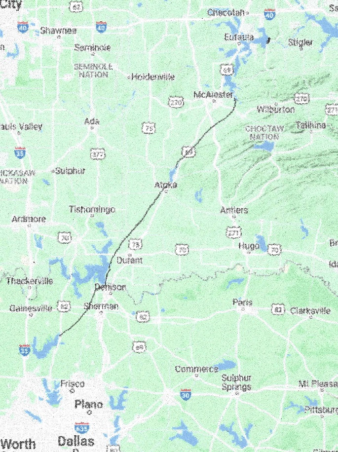
From there the real aqueduct will start, unencumbered by barge traffic regulation. It will go from the southern tip of Lake Eufaula to lake Atoka, a distance of 40 miles. Lake Atoka is 10 miles long.
Lake Atoka elevation is 590′
Then from Lake Atoka it will pass by lake Texoma on ther downslope of thee Denison dam at an elevation of 640′. From there it will go to Lake Ray Roberts
Leg 3 total length 50miles lake, 125 miles aqueduct, end point Lake Ray Roberts, elevation 625′
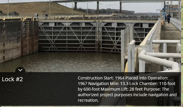
The elevation at lake Atoka is about 590′. The aqueduct will have a capacity of 22,000 cfs, and it will climb from Eufaula to about 740′ before going down again to lake Atoka. From lake Atoka it will only pump up water for 85 miles. The aqueduct water level drops by 2′ per mile. Total pumping up will be 365′ and going down water release will be 110′ The total power need for this stage will be up to 665 MW assuming 92% pumping and generation efficiency. three 200 MW LFTR SMR will take care of the power needs this stage, and can be used for peak power generation when pumping is temporarily shut off. It is important to keep the water level steady at Lake Ray Roberts.
What’s in it for Oklahoma? Eufaula lake flood control will be greatly enhanced. Lake Atoka flood control will be enhanced and in case of drought extra water will be supplied to keep lake levels steady. There will be about 200 MW virtual hydro-power energy provided for up to 5 hours/day to stabilize the grid with peak power.
What’s in it for Texas? In case of drought Lake Ray Roberts can supply extra water to the Dallas area. The water levels will be stabilized at Lake Ray Roberts. There will be about 400 MW virtual hydro-power energy provided for up to 5 hours/day to stabilize the Texas grid with peak power.
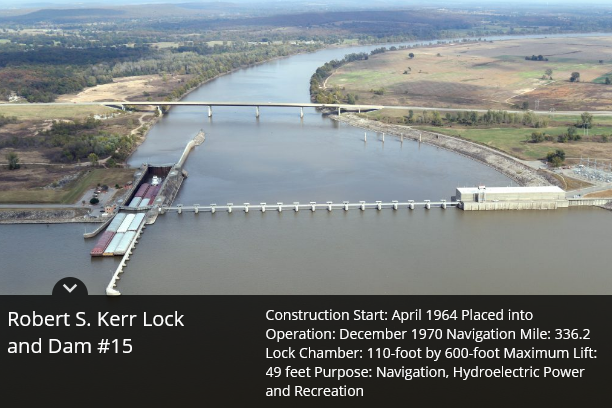
The length of Leg 2 is 20 miles on the Robert S Kerr reservoir and 22 miles on the Canadian river.
Elevation 458′
The Robert S Kerr reservoir has an area of 43,000 acres and its elevation is regulated by the McClellan-Kerr Arkansas River Navigation System. This means that the water can be pumped up or released as long as it is coordinated for the whole canal system. This also means that the water flow can be stopped and the power normally used to pump up water can be used as peak power, which can come in handy on a hot humid day with no sun and no wind and every air conditioner in the area is going full blast to take out the oppressive humidity.
The part of the aqueduct going up the Canadian river will have 3 20 ft dams with concrete spillways, each with a 20,000 cfs reversible flow pumping station. The map:
The dam will have a 20,000 cfs pumping station added lifting water 87 ft.
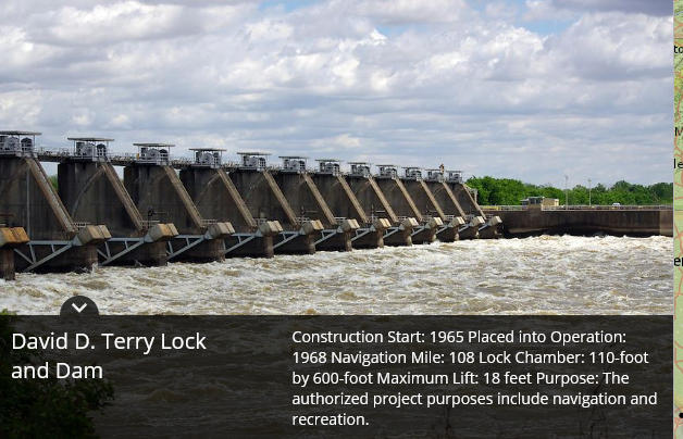
The Eufaula Dam. The Eufaula dam Riverbed at 498′ conservation pool at 585′
The total power consumption in this stage will be up to 265 MW. The preferred power plant will be 3 100 MW LFTR SMRs.
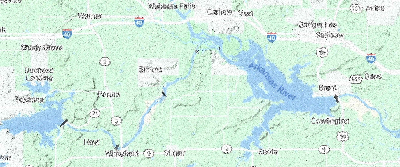
The Trans-Continental aqueduct starts out at the Mississippi river, and for the first leg follows the Arkansas River from Mississippi River to Lock15 of the Arkansas River, a distance of 319 miles.
Location of the locks and pumping stations on the Arkansas river.
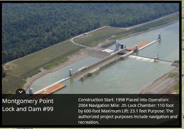
Lock 1, entrance from the Mississippi River to the White river. The water surface at Montgomery Point has fluctuated from elevation 104′ to 172′.
This lock was added later to better accommodate barge traffic when the Mississippi River was running abnormally low. If the Mississippi is normal to high level, this lock is bypassed. Since we are going to move 23,200 cfs of water over the rocky mountain the flow amount in Arkansas river will be reduced by the same amount. In times of drought, the Arkansas River flow is most often less than 23,200 cfs. To alleviate that, a series of 20,000 cfs pumps will be installed, one in every lock of the canal, beginning with Lock 3.
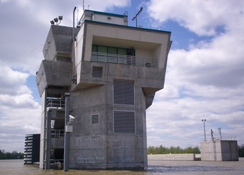
Montgomery Point Lock and Dam features “first of its kind” hydraulically operated gates. When the tail water is at elevation 115′ and rising, the dam gates are flat on the bottom of the river and barge traffic passes over the gates in the navigation pass spillway to minimize lockages saving time and money.This lock is frequently submerged. Only the top of the control tower remains above water
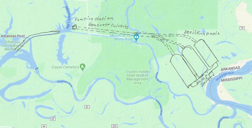
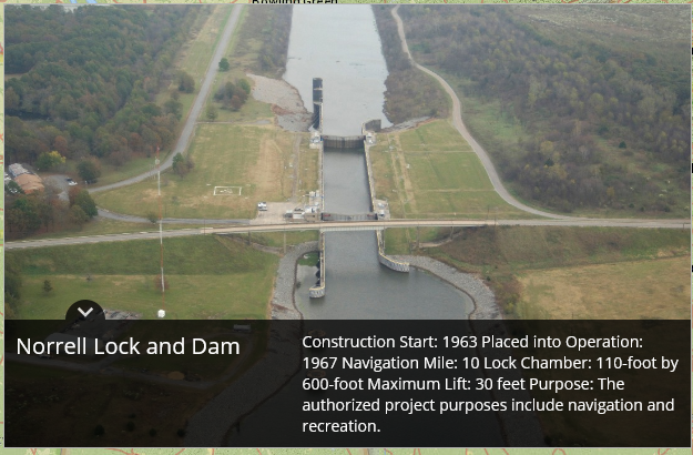
The Mississippi river is muddy. When water is pumped up there needs to be a number of de-silting pools, where the silt is returned to the Mississippi river. Here is suggested 3 pools, each capable of de-silting 10,000 cfs of water, one for the Trans-Rocky Mountain aqueduct, and two for the Trans-Continental aqueduct, being built as the whole aqueduct is nearing completion. The top of the pools is set at 150 ft elevation. Should the Missisippi River flood higher than 142 feet the operation will be shut down until elevation is below 142 feet again, and Lock 2, the Norrell Lock and dam is operational again. For the Trans-Continental aqueduct up to 20,000 cfs needs to be pumped up between 20 and 62 feet, for an energy consumption of between 1MW and 112 MW. The map below show one possible location for the pools:
The de-silting pools.Elevation 142′ No changeElevation 162′ No changeElevation 182′Elevation 1196′Elevation 213′Elevation 231′Elevation 249Elevation 265′Elevation 284′Elevation 336′Elevation 370′Elevation 391′Elevation 412′Elevation 458′
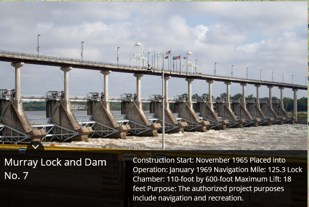
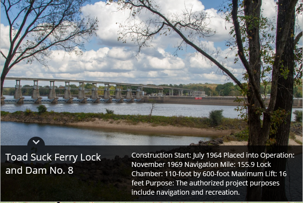
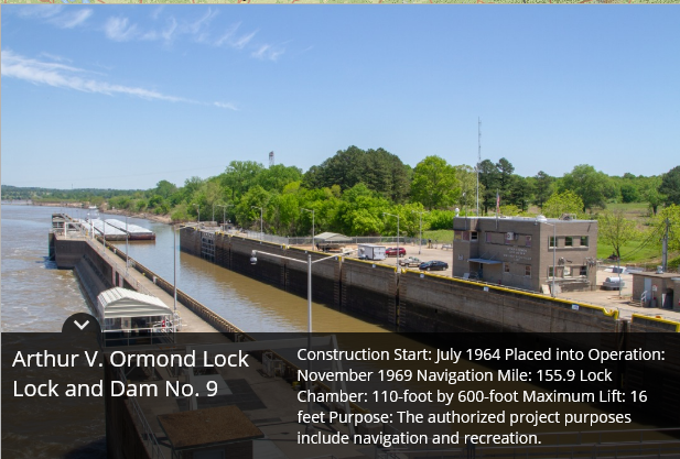
From Lock # 3 to lock # 15 (12 locks # 11 is missing) the Power houses have to either replace two of the operating turbines to a corresponding dual function pump/generator, or add a 20,000 cfs pump.
By removing 20,00 cfs from the flow of water in the Arkansas river, it will be necessary to add these pumps to ensure functioning locks even in times of extreme droughts. The total power generated by the power stations will be reduced by 20,000 cfs times (458 – 127) feet * 0.9 or about 630 megawatts total. This is most of the time all the power that was generated, so the standard hydropower generation in the Arkansas river will be for all practical purposes eliminated.
As a side note, every lock opening uses up water equivalent of between 22 and 66 kWh depending on the size of the lift or lowering of the barges. This is constant and not dependent on the size of the barges or boats. When the spillways are in use, the water is “free”, but otherwise every lock opening costs a few dollars in energy, not much, but in case of a drought the fact that water is pumped back up the river will help increase the capacity.
What is in it for Arkansas? The added pumps will give an additional tool to control the canal system. In addition, in the case of floods it will somewhat alleviate the flood control, and serve the canal system better in times of drought. To add 630 megawatts to the system, may I suggest 3 200 MW LFTR nuclear reactors, they are carbon neutral. In addition they have the ability to shut off the pumping of water and let the power plants provide 600 MW virtual hydro-storage power for up to five hours/day. The barges will benefit from sometimes go with the flow, and sometimes travel over still water, shortening the time of transport substantially.
The power companies in California asked people to avoid charging their electric vehicles to lessen the strain on the power grid.
California has a giant power problem. It depends on solar power to over 10% and wind power to 10%, but depends on hydro power for over 13% of their needs. The two last nuclear power plants in Diablo Canyon, supplying 9% of Californians electricity are being shut down in 2024 and 2025. Hydro-power is declining because of the drought, so the rest has to be made up by fossil fuels and imports from other states. Therefore California has one of the largest transmissions losses of any state, close to 10%. When the wind doesn’t blow and the sun doesn’t shine they import peak power at a price that has a few times been as high as one dollar per kWh. But they are building fast charging stations for their electric vehicles:
This one is in Menlo Park, Ca. Where Else?
The infrastructure bill will add $7.5B in EV charging stations, which could result in around 1,900 highway and rural stations, 100,000 urban stations, and 215,000 Level 2 stations for workplaces, apartments, and airports. There are already 45,000 private charging stations, and s number of exclusive Tesla charging stations. And then there is no saying how many are installing a fast charger in their garage. If electric cars really takes off we will have to greatly expand our electric grid, which is still powered over half with fossil fuels.
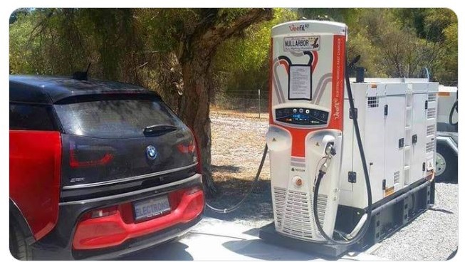
But fear not, when all else fails, here is a diesel powered electric charging station for your electric vehicle:
Should you run out of charge there is always AAA:
I am for electric vehicles as soon as the electric grid is fixed up, the dependency of fossil fuel to stabilize the grid and the grid is built up to accommodate electric vehicles being charged at the same time. As it is now, over half of all electricity is still produced using fossil fuels, and coupled with 10% transmission losses and conversion losses, plus that electric vehicles use electricity to get heated, they are not carbon neutral.
I have a proposal to solve the water problems in the American Southwest and at the same time triple the nation’s hydro-power storage capacity allowing for a greater use of solar panels, and some windmills, they will be a small part of the solution, but the great change will be the use of Small Modular Reactors, preferably Liquid Fluoride Thorium Reactors. The proposal is here-.
The Democrats greatest concern was Climate Change, followed by Election Laws and Inflation. At the bottom of the list was the Supreme Court.
The Republicans greatest concern was Inflation, followed by Immigration and Crime. At the bottom of the list was Climate Change.
The Independents greatest concern was Inflation, followed by Immigration and COVID-19. At the bottom of the list was Unemployment.
For Blacks there was a tie between COVID-19 and Inflation as their greatest concern, followed by Racial Inequality. At the bottom of the list was the Supreme Court.
And for Hispanics the greatest concern was Inflation, followed by Climate change and COVID-19. At the bottom of the list was Supreme Court.
The biggest concern was Inflation for everybody but Democrats. Their biggest concern was Climate Change, but for Republicans that was the least of their worries.
Why is that?
Some Democrats believe with religious fervor that we have only limited time to solve the climate crisis before we reach the point of no return. Alexandra Occasio Cortez said in January 2019 that if we didn’t abolish fossil fuel asap the world will end in 12 years. There is now less than 9 years left. President Trump ended our part in the Paris accord, and President Biden rejoined it in 2021. If we fulfill all the Paris accord demands, the world temperature, according to the UN agency IPCC will rise 0.05 C cooler by 2030, and a whopping 0.17C less by 2100. See analysis here. Meanwhile, China is in negotiations to buy another 100 million metric tons of Coal from Russia. They consume half the world’s coal mining.
For other Democrats it is another method of gaining control of all production and consumption, the Venezuelan model.
Then there is the sustainability crowd, and they point out the obvious fact, that unless something is done, we will run out of Coal, Oil and Gas sometimes in the not too distant future. Their suggested solution is to build Wind Turbines with generators made in China and western Europe. Solar panels are mostly built in China. But that is not the worst part. To build these generators and solar panels we need rare earth metals, 80% of which come from China. Details here. The problem is what to do when the sun doesn’t shine, which is most of the time, and the wind doesn’t blow. Energy must then be produced by other means. For now it is generated by coal and natural gas plus some diesel generators. Battery technology is not there yet, and hydro-power storage is way inadequate for today’s need.
And then there is John Kerry, who’s greatest fear is that the war in Ukraine will distract us from our greatest threat, Climate Change. His latest concern on Migration: “Wait until you see 100 million people for whom the entire food production capacity has collapsed.”
Some Republicans thank God for the increased CO2 levels because thanks to that the world can now keep an additional 2 billion people from starving. It seems hard to believe, but as food yield increases in greenhouses when additional CO2 is added, so does the greenhouse called earth benefit from more CO2. Don’t believe me? Look at this map:
This means more roots for plants, less erosion, and more food for animals. The exception is desert areas.
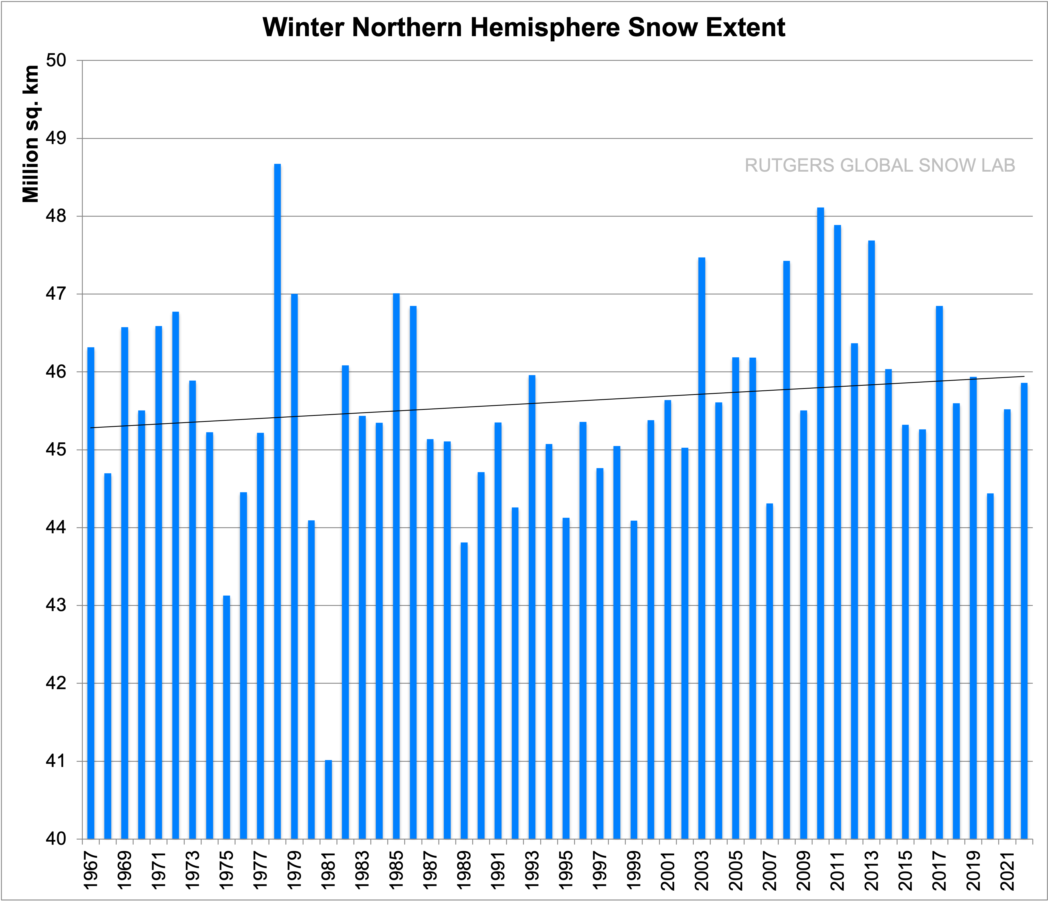
Others have noticed that the dire predictions from IPCC, a UN Climate Change Panel, have always been way off base. The temperature increase, while real has always been way below what is predicted. It is predicted that the largest temperature increases occur at the poles, so this summer the South Pole had its coldest winter on record. A weather station at the Amundsen-Scott South Pole Station registered record cold winter temperatures this season (April – September), averaging at -61.1 °C (-77.9 °F) and breaking the previous record set in 1976 at -60.6 °C (-77 °F). Weather records date back to 1957. The North Pole on the other hand is experiencing a warmer trend, but only in the winter. The summers are marginally cooler, but that is because there is more now to melt. Yes, the Snow over the Arctic is increasing. See the chart from Rutgers Snow Lab:
These are but a few of the differences in opinion concerning Climate change. Let’s see where democrats and republicans live. If we look at the 2020 voting results the map looks nearly all Republican: (84% of the counties voted Republican)
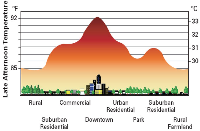
Yet there were more Democrat votes cast than Republican. This is because the largest counties population wise vote Democrat and they experience Climate Change big time thanks to the so called Urban Heat Island effect:
This is late afternoon, somewhere in Urban USA.
People living in the rural America do not experience the Urban Heat Island effect, so they tend to dismiss the constant drumbeat from PBS, everything bad is because of climate change as just idle talk. What do they know; they are stuck in their asphalt jungle complaining about how bad things are. The rural people remember how their grandparents used to say it was much worse in the thirties, heatwave after heatwave and everything dried up. And dust storms and wildfires were much worse. Not to mention the winters, the Mississippi river froze all the way down to New Orleans. We have never has it so good as it is now. Poor Urban Heat Island dwellers.
The Democrats solution to Climate Change is: Eliminate CO2 emissions from fossil fuels and replace with wind and solar but not nuclear power. All cars trucks, trains and busses should be electric. This is impossible.
Republicans want to gradually lessen our dependency of fossil fuel and make electric production come from Nuclear power, preferably small modular Thorium reactors. They have many advantages explained here. There are immense environmental problems, it is not CO2 or even Methane, but water. The American South-west has too little water for its growing population and the east US has sometimes too much. One possible solution is described here.
President Biden had the U.S. join the Paris accord and we are once again in accord with the IPCC and UN. Unfortunately, if we comply with all the requirements of the Paris accord we will lower the temperature increase by only 0.05C by 2030, and by only 0.17C by 2100. See the reasons why this is so here. How can that be? It is because the real climate change is not mainly caused by increasing CO2 and Methane. No, these are only minor players compared to land use changes such as deforestation, aquifer depletion, urbanization, erosion and so on.
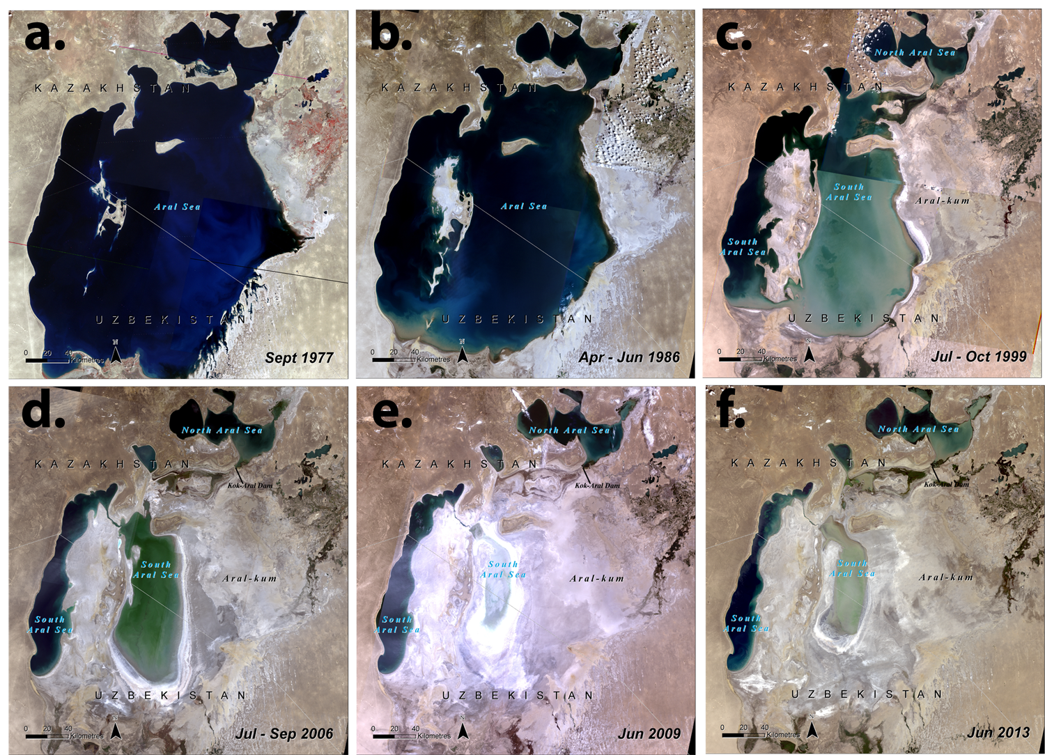
One of the worst consequences of government controlled land use changes is the disappearance of Lake Aral in Asia, the fourth largest lake in the world. It provided a sensitive, but functioning Eco-system for a large portion of South East Soviet Union and western Afghanistan. Then the central planners wanted to improve the productivity of the area through irrigation and changing land management. In the 1960s and 1970s the Soviets started using the Amu Darya and the Syr Darya rivers to irrigate extensive cotton fields in the Central Asian plain. The results can be seen in these 6 Satellite photos
Disaster is a mild word. The lake was the source of the rains that fell up-stream. With the lake gone, the rivers dried up completely, and the whole upland became desert-like. There has been efforts to restore the upper part of the lake with a dam, but that will do nothing to reverse the desertification.
Another land use change is urbanization. This produces an urban heat island that can increase the temperature in the city by as much as 4C compared to forested surroundings.
Yes, there is significant climate change for the people living in the downtown areas. It is called urbanization. The globe as a whole does not experience it, but the people living in the asphalt jungles surely do. One could turn off the air conditioners, but their contribution is less than one degree on average. Far bigger is the fact that the albedo changes, the ground dries up, and when it rains it all gets flushed out in the streams or simply evaporates on the burning hot asphalt or concrete. One hour after the rain it is as hot as before.
Another climate change occurs when forested land is cleared but not replanted, or when land is overgrazed down to the roots. In these cases the streams dry out hillsides and floodplains, and flash floods occur instead of steady streams, and erosion causes major damages. And so it is with much of the American Southwest. The average temperature increase from deforestation and overgrazing is usually around 1C. This video explains it much better than may words. There is still hope, but it will take work
Why can’t this be done here in the dry American southwest? It involves water rights. Unless the property owner owns the water rights to the land the owns he has no right to harvest any of the rain that falls on it. If he improves the land with a road or a structure with a roof, all the rain that falls on it must be going to the river, and eventually to Lake Mead to prevent it from going dry. In the Eastern United states water rights are automatic, they are in fact water responsibilities. If you improve the land and build a road, parking lot or a structure with a roof, you must build a catch basin big enough to capture all the extra runoff generated by the rain falling on the improved land. Farmers are encouraged to build swales to minimize erosion and runoff of fertilizer and pesticide. This should also be done in the dry parts of the country, there their erosion problems are even worse. The way to do it is determined by local factors and should be decided at the local or regional level. When the federal government gets involved they tend to mandate one solution for all, and the needs for Arizona is quite different from the needs for Louisiana when it comes to water.
Here is the suggestion: Give this challenge to all local Universities and High School biology departments. Make a competition to come up with the best local solutions to restore the American Southwest if the water rights belonged to the land. The only limits are; you can not dam established creeks and you cannot draw water from the aquifers. The indigenous people once knew how to do it. Unfortunately, the American Southwest can suffer multiyear droughts, and, unlike in India, the monsoons can fail. The greening that occurred in the five projects mentioned in the video above should act as an inspiration. The greening that will occur will lower the temperature, drastically reduce erosion, provide a more permanent water flow in the rivers, and reduce flooding.
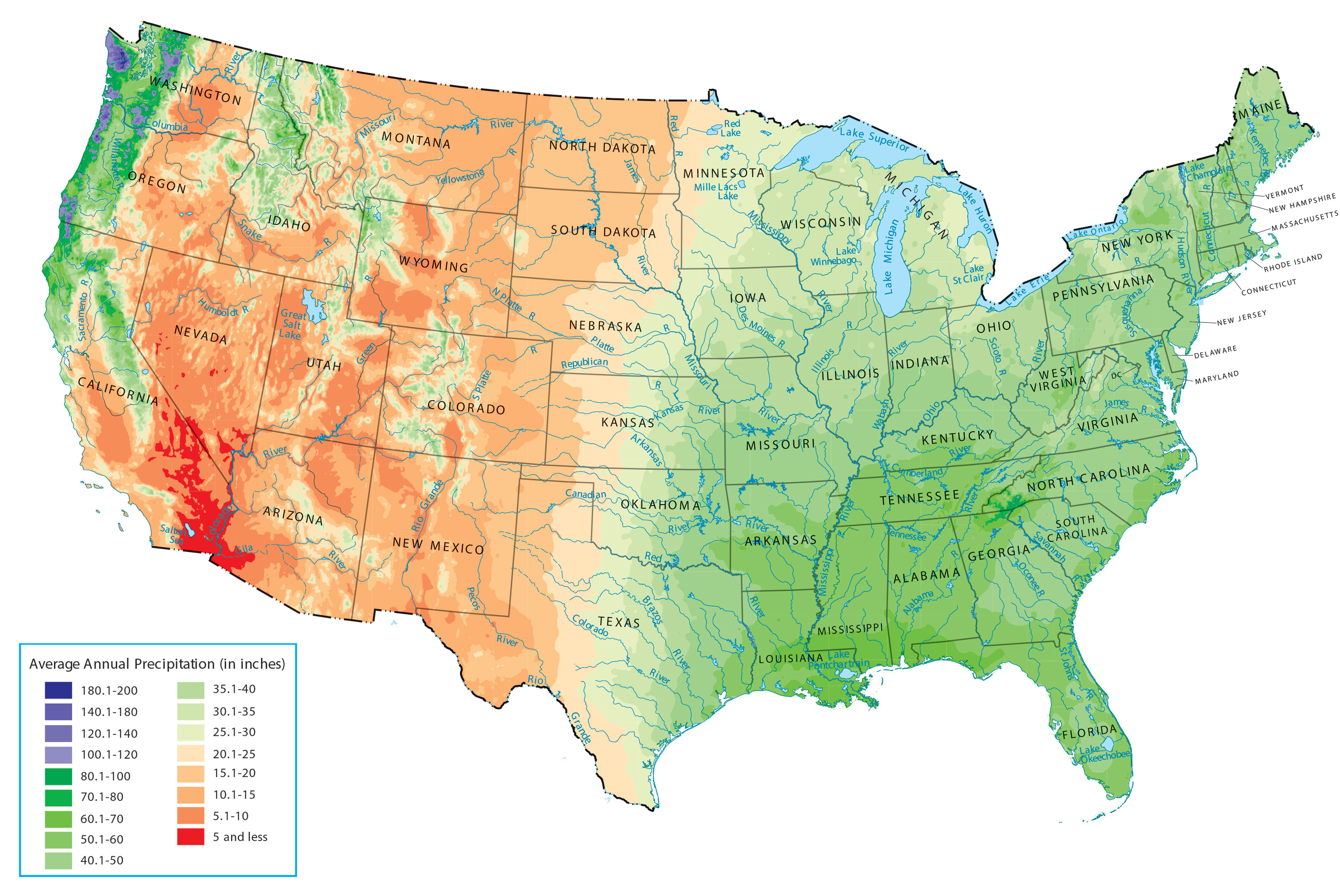
When the Hoover dam was built the population in the American south west was around seven million. Now the population dependent on the water from the Colorado river is over 40 million, and growing. Not only is the Colorado River water supply insufficient, but the aquifers are being depleted, and the desertification is starting to set in. Looking at a precipitation map of the U.S. there is one obvious solution.
Green areas have enough water, orange, brown or red areas are water sparse.
Bring water from the east to the west! There is only one big problem: The Rocky Mountains are in the way. The water must be lifted around 8,000 feet before it will start to flow downhill again. To lift one acre-ft of water one foot requires about 1.08 kWh. Some energy is regained on the way down, but the net energy needed is around 5,000 kWh per acre-ft of water delivered to the thirsty American South-west.
This proposal is to deliver up to 23.75 million acre-feet of water annually to the thirsty American South-west. It will consist of three aqueducts:
The first one is called the South Platte Aqueduct and will serve Eastern Colorado and help save the High Plains Aquifer, also called the Ogallala Aquifer. It is sketched out here. It is quite modest, only up to 750,000 acre-ft pumped annually, and while the aqueduct will be built to this capacity only 375,000 acre-feet will be initially needed. For now, it will serve about 5 million people.
The second is the Trans-Rocky-Mountain Aqueduct. It will serve the upper Colorado River Basin and the upper Rio Grande Basin. When fully used it will pump 8 million acre-ft yearly from the Mississippi/Arkansas River. It is more fully described here .
The third is the Transcontinental Aqueduct. It will serve the Lower Colorado River Basin, Southern New Mexico and Western Texas. It will pump up to 15 million acre-ft of water annually from the Atchafalaya river (Mississippi river bypass) all the way to southern Colorado River. It is described more fully here.
The total electricity need to accomplish this giant endeavor is about 120 billion kWh annually. or about three percent of the current US electricity demand. In 2020 the US produced 1,586 billion kWh from natural gas, 956 from coal, 337.5 from wind and 90.9 from solar.
For this giant project to have any chance of success there has to be something in it to be gained from every state that will be participating. Here are some of the benefits:
Arizona: Arizona needs more water. The water from Mississippi is less saline and better suited for agriculture and the people growth makes it necessary to provide more water sources. Right now the aquifers are being depleted. Then what? One example: The San Carlos lake is nearly dry half the time and almost never filled to capacity. With the aqueduct supplying water it can be filled to 80 +- 20% of full capacity all the time. In the event of a very large snow melt the lake level can be reduced in advance to accommodate the extra flow. Likewise during Monsoon season the aqueduct flow can be reduced in anticipation of large rain events. Arizona together with New Mexico has the best locations for solar power, but is lacking the water necessary for hydro-power storage. This proposal will add 13.6 GW of hydro-power storage capable of adding 68 GWh of electric peak power daily.
Arkansas: The main benefit for Arkansas is better flood control and river control of the Arkansas River and allowing it to deepen the draft for canal barges from 9,5 feet to 12 feet, which is standard on the Mississippi river.
California: The water aqueduct serving Los Angeles will be allowed to use maximum capacity at all times. Additional water resources will be given the greater San Diego area. The Imperial valley will be given sweet Mississippi water, which will improve agriculture yield. The polluted New River will be cut off at the Mexico border. There will be water allocated to the Salton Sea. There is a proposal to mine the world’s largest Lithium ore, mining the deep brine, rich in Lithium. (about a third of the world supply according to one estimate). This requires water, and as a minimum requirement to allow mining in the Salton Sea the water needs to be cleaned. This requires further investigation, but the area around the Salton Sea is maybe the most unhealthy in the United States. It used to be a great vacation spot.
Colorado: The future water needs from Fort Collins to Colorado Springs metropolitan area will be met. In addition the Pueblo area will be allowed to use more of the Arkansas River water, since the John Martin Reservoir will be filled by the Trans-Rocky Mountain aqueduct.
Kansas: It will get a reliable water supply to serve Wichita and all towns along the Arkansas River in times of drought and to serve additional water needs at all times. It will also improve flood control along the river.
Louisiana: The main benefit for Louisiana is: By siphoning off up to 23.75 million acre-ft/year from the Mississippi river it will lower the flow through the lower Mississippi, especially New Orleans, reducing flood risk. By making these aqueducts the whole Mississippi/Missouri watershed will be incentivized to make sure the river waters are clean enough to be able to use as water supply. This will positively affect 40% of the continental United States landmass.
Mexico: During the negotiations about who was going to get the water in Lake Mead Mexico did not get enough water, so they have been using all remaining water for irrigation, and no water is reaching the ocean anymore. In addition the water is too salty for ideal irrigation. This proposal will provide sweet Mississippi water to Mexico, ensure that some water reaches the Colorado river delta. This will restore the important ecology and restore aquatic life in the delta and the gulf. The town of Mexicali will get some water in exchange for shutting off New River completely.
Nebraska: One of the benefits for Nebraska is that it will help save the Ogallala aquifer. The farmers close to the aqueduct will use pumped water from Missouri rather than draw from the aquifers.
Nevada: Las Vegas is a catastrophe waiting to happen unless Lake Mead is saved. With this proposal there will be ample opportunity to make the desert bloom.
New Mexico: The state is ideally suited for solar panels. In addition to give much needed water to communities along the length of the aqueduct, it will provide 10.5 GW of hydro-power storage to be made available at peak power usage for up to 5 hours a day.
Oklahoma: The main advantage for Oklahoma is a much improved flood control, especially through the City of Tulsa. It will provide the same advantage for river barge traffic as benefits Arkansas.
Texas: The state has a big problem. It has already built up too much wind power and can not give up their coal burning power plants until the electricity is better balanced. They have no hydro-electric power storage at all, and we saw the result of that in last year’s cold snap. This proposal will give the Texas electric grid 18.5 GW of hydro-electric power for up to 5 hours a day.
Utah: The state will no longer be bound to provide water to Lake Mead, but can use all of its water rights for Utah, especially the Salt Lake City region.
Wyoming: The state will be free to use the water in the Green River and all the yearly allocated 1.05 million acre-feet of water can be used by the state of Wyoming.
The cost to do all these aqueducts will be substantial, but it can be done for less than 400 billion dollars in 2021 money, and that includes the cost of providing power generation. Considering it involves 40 million people dependent on the Colorado River now and another 10 million east of the Rocky Mountains, it is well worth doing, much more importand to do than other “green” projects, since it will save the American Southwest from becoming an uninhabitable desert.
This proposed solution cannot be made possible without changing our approach to power generation. The mantra now is to solve all our power needs through renewables. Texas has shown us that too much wind power without any hydroelectric power storage can lead to disaster. In addition, windmills kill birds, even threatening some species, such as the Golden Eagle and other large raptors that like to build their aeries on top of the generators. Solar panels work best in arid, sunny climate, such as Arizona and New Mexico, but the panels need cooling and cleaning to work best, and that takes water. They are even more dependent on hydro-power storage than wind. The transcontinental aqueduct will triple the hydro-electric power storage for the nation, and the Trans-Rocky-Mountain will add to it. Without hydro-electric power storage we still need all the conventional power generation capacity for when the sun doesn’t shine and the wind doesn’t blow.
Conventional Nuclear power plants doesn’t work in most places since they depend on water for their cooling, and most of these aqueducts pump water in near deserts, and there would be too much evaporation losses to use water from the aqueducts for cooling.
The only realistic approach would be to use LFTR power plants. (Liquid Fluoride Thorium Reactors). There are many advantages for using LFTR. Here are 30 reasons why LFTRs is by far the best choice.
For this project to succeed there must be developed a better way to build SMRs (Small Modular Reactors, less than 250 MW) more effectively. The price to build a LFTR plant should be less than $2.50 per watt. While the LFTR science is well understood, the LFTR engineering is not fully developed yet, but will be ready in less than 5 years if we get to it. In the mean time there should be built one or more assembly plants that can mass produce LFTR reactor vessels small enough so they can be shipped on a normal flatbed trailer through the normal highway system. My contention is that a 100 MW reactor vessel can be built this way and the total cost per plant will be less than 250 Million dollars. To save the American Southwest we will need about 350 of them, or 87,5 billion dollars total. This cost is included in the total calculation. There will be many more of these plants produced to produce all the electric power to power all the electric vehicles that are going to be built. This is the way to reduce fossil fuel consumption. Just switching to electric vehicles will not do the trick. The electric energy must come from somewhere. To convert all cars and trucks and with unchanging driving habits will require another 600 GW of generating capacity by 2050, our present “net zero emissions” goal.
To do this project we need cooperation from all states in providing dominant domain access. The Federal government will need to approve LFTR as the preferred Nuclear process and streamline approval from many years to less than one year.
Ever since beginning of time the battle has been about water. The garden of Eden was watered by four rivers, but ever since Adam and Eve were exiled from it, water has been the major concern. In the Middle East the first treaty between Abraham and Abimelech was about water and who was to control it. In Exodus 7:19 (NIV) The LORD said to Moses, “Tell Aaron, ‘Take your staff and stretch out your hand over the waters of Egypt—over the streams and canals, over the ponds and all the reservoirs—and they will turn to blood.’ In Ezra 8:15 concerning the return to Jerusalem Ezra wrote: I assembled them at the canal that flows toward Ahava, and we camped there three days. In Daniel 8:2 Daniel wrote “In my vision I saw myself in the citadel of Susa in the province of Elam; in the vision I was beside the Ulai Canal.” And in Isaiah 19:6 Isaiah Prophesied “The canals will stink; the streams of Egypt will dwindle and dry up.” This means the Nile River would still flow, but the intricate canal system would fail.
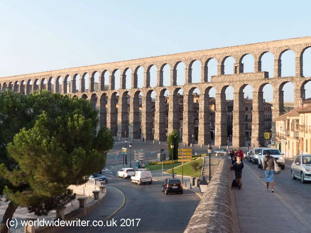
The Romans built many aqueducts. Rome had 11 aqueducts to supply it with water. One of the most impressive aqueducts is the Segovia Aqueduct in Spain.
This aqueduct has been maintained through the centuries and supplied Segovia with water as late as the 19th century.
Even in the dry American south-west canals have been built for irrigation in the past, check out this video from the Arizona State University:
When the Hoover dam was built the population in the American south west was around seven million. Now the population dependent on the water from the Colorado river is over 40 million, and growing. Not only is the Colorado River water supply insufficient, but the aquifers are being depleted, and the desertification is starting to set in. Looking at a precipitation map of the u.s there is one obvious solution.
Green areas have enough water, orange, brown or red areas are water sparse.
Bring water from the east to the west! There is only one big problem: The Rocky Mountains are in the way. The water must be lifted around 8,000 feet before it will start to flow downhill again. To lift one acre-ft of water one foot requires about 1.08 kWh. Some energy is regained on the way down, but the net energy needed is around 5,000 kWh per acre-ft of water delivered to the thirsty American South-west.
This proposal is to deliver up to 23.75 million acre-feet of water annually to the thirsty American South-west. It will consist of three aqueducts:
The first one is called the South Platte Aqueduct and will serve the Eastern Colorado and help save the High Plains Aquifer, also called the Ogallala Aquifer. It is sketched out here. It is quite modest, only up to 750,000 acre-ft pumped annually, and while the aqueduct will be built to this capacity only 375,000 acrefeet will be initially needed. For now, it will serve about 5 million people.
The second is the Trans-Rocky-Mountain Aqueduct. It will serve the upper Colorado River Basin and the upper Rio Grande Basin. When fully used it will pump 8 million acre-ft yearly from the Mississippi/Arkansas River. It is more fully described here .
The third is the Transcontinental Aqueduct. It will serve the Lower Colorado River Basin, Southern New Mexico and Western Texas. It will pump up to 15 million acre-ft of water annually from the Atchafalaya river (Mississippi river bypass) all the way to the southern Colorado River. It is described more fully here.
The total electricity need to accomplish this giant endeavor is about 120 billion kWh annually. or about three percent of the total US electricity demand. In 2020 the US produced 1,586 billion kWh from natural gas, 956 from coal, 337.5 from wind and 90.9 from solar.
For this giant project to have any chance of success there has to be something in it to be gained from every state that will be participating. Here are the benefits
Arizona: Arizona needs more water. The water from Mississippi is less saline and better suited for agriculture and the people growth makes it necessary to provide more water sources. Right now the aquifers are being depleted. Then what? One example: The San Carlos lake is nearly dry half the time and almost never filled to capacity. With the aqueduct supplying water it can be filled to 80 +- 20% of full capacity all the time. In the event of a very large snow melt the lake level can be reduced in advance to accommodate the extra flow. Likewise during Monsoon season the aqueduct flow can be reduced in anticipation of large rain events. Arizona together with New Mexico has the best locations for solar power, but is lacking the water necessary for hydro-power storage. This proposal will add 13.6 GW of hydro-power storage capable of adding 68 GWh of electric peak power daily.
Arkansas: The main benefit for Arkansas is better flood control and river control and allowing to deepen the draft for the canal barges from 9,5 feet to 12 feet, which is standard on the Mississippi river.
California: The water aqueduct serving Los Angeles will be allowed to use maximum capacity at all times. Additional water resources will be given the greater San Diego area. The Imperial valley will be given sweet Mississippi water, which will improve agriculture yield. The polluted New River will be cut off. There will be water allocated to the Salton Sea. Proposed will be the to mine world’s largest Lithium ore, mining the deep brine, rich in Lithium. (about a third of the world supply according to one estimate). This requires water, and as a minimum requirement to allow mining in the Salton Sea the water needs to be cleaned. This requires further investigation, but the area around the Salton Sea is maybe the most unhealthy in the United States. It used to be a great vacation spot.
Colorado: The future water needs from Fort Collins to Colorado Springs metropolitan area will be met. In addition the Pueblo area will be allowed to use more of the Arkansas River water, since the John Martin Reservoir will be filled by the Trans-Rocky Mountain reservoir.
Kansas: It will get a reliable water supply to serve Wichita and all towns along the Arkansas River in times of drought and to serve additional water needs at all times. It will also improve flood control along the river.
Louisiana: The main benefit for Louisiana is: By siphoning off up to 23.75 million acre-ft/year from the Mississippi river it will lower the flow through the lower Mississippi, especially New Orleans, reducing flood risk. By making these aqueducts the whole Mississippi/Missouri watershed will be incentivized to make sure the river waters are clean enough to be able to use as water supply. This will positively affect 40% of the continental United States landmass.
Mexico: During the negotiations who was going to get the water in Lake Mead Mexico did not get enough water, so they have been using all remaining water for irrigation, and no water is reaching the ocean anymore. In addition the water is too salty for ideal irrigation. This proposal will provide sweet Mississippi water to Mexico, ensure that some water reaches the Colorado river delta. This will restore the important ecology and restore aquatic life in the delta and the gulf. The town of Mexicali will get some water in exchange for shutting off New River completely.
Nebraska: One of the benefits for Nebraska is that it will help save the Ogallala aquifer. The farmers close to the aqueduct will use pumped water from Missouri rather than draw from the aquifers.
Nevada: Las Vegas is a catastrophe waiting to happen unless Lake Mead is saved. With this proposal there will be ample opportunity to make the desert bloom.
New Mexico: The state is ideally suited for solar panels. In addition to give much needed water to communities along the length of the aqueduct, it will provide 10.5 GW of hydro-power storage to be made available at peak power usage for up to 5 hours a day.
Oklahoma: The main advantage for Oklahoma is a much improved flood control, especially through the City of Tulsa. It will provide the same advantage for river barge traffic as benefits Arkansas.
Texas: The state has a big problem. It has already built up too much wind power and can not give up their coal burning power plants until the electricity is better balanced. They have no hydro-electric power storage at all, and we saw the result of that in last year’s cold snap This proposal will give them 18.5 GW of hydro-electric power for up to 5 hours a day.
Utah: The state will no longer be bound to provide water to Lake Mead, but can use all of its water rights for Utah, especially the Salt Lake City region.
Wyoming: The state will be free to use the water in the Green River and all the yearly allocated 1.05 million acre-feet of water can be used by the state of Wyoming.
The cost to do all these aqueducts will be substantial, but it can be done for less than 400 billion dollars in 2021 money, and that includes the cost of providing power generation. Considering it involves 40 million people dependent on the Colorado River now and another 10 million east of the Rocky Mountains, it is well worth doing, much more than other “green” projects, since it will save the American Southwest from becoming an uninhabitable desert.
This proposed solution cannot be made possible without changing our approach to power generation. The mantra now is to solve all our power needs through renewables. Texas has shown us that too much wind power without any hydroelectric power storage can lead to disaster. In addition, windmills kill birds, even threatening some species, such as the Golden Eagle and other large raptors that like to build their aeries on top of the generators. Solar panels work best in arid, sunny climate, such as Arizona and New Mexico, but the panels need cooling and cleaning to work best, and that takes water. They are even more dependent on hydro-power storage than wind. The transcontinental aqueduct will triple the hydro-electric power storage for the nation, and the Trans-Rocky-Mountain will add to it. Without hydro-electric power storage we still need all the conventional power generation capacity for when the sun doesn’t shine and the wind doesn’t blow.
Conventional Nuclear power plants doesn’t work either since they depend on water for their cooling, and most of these aqueducts pump water in near deserts, and there would be too much evaporation losses to use the aqueduct’s water for cooling.
The only realistic approach would be to use LFTR power plants. (Liquid Fluoride Thorium Reactors). There are many advantages for using LFTR. Here are 30 0f them.
For this project to succeed there must be developed a better way to build small nuclear plants more effectively. The price to build a LFTR plant must be less than $2.50 per watt. The LFTR technology is not fully developed yet, but will be ready in less than 5 years. In the mean time there should be built one or more assembly plants that can mass produce LFTR reactor vessels small enough so they can be shipped on a normal flatbed trailer through the normal highway system. My contention is that a 100 MW reactor vessel can be built this way and the total cost per plant will be less than 250 Million dollars. To save the American Southwest we will need about 350 of them, or 87,5 billion dollars total. This cost is included in the total calculation. There will be many more of these plants produced to produce all the electric power to power all the electric vehicles that are going to be built. This is the way to reduce fossil fuels. Just switching to electric vehicles will not do the trick. The energy must come from somewhere.
Lake Powell and Lake Mead will be emptied in less than 10 years with the current usage pattern. Then what?
The hydroelectric power from Lake Mead (and Lake Powell) is diminishing as the lakes are emptied.
the aquifers are drawn down everywhere in the Southwest, but also the Ogallala Aquifer in Colorado and Kansas, and are at risk of being exhausted.
The Colorado River water is too salty for good irrigation .
The Colorado river no longer reaches the Gulf of California. Fishing and shrimp harvesting around the Colorado River Delta is no more.
40 million people depend on the Colorado River for drinking water. The population is still rising rapidly in the West. Will they have water in the future? Think 20 million future population growth in the next 40 years, people want to move there even with the current water problems.
The solution:
Build a Trans-Rocky-Mountain aqueduct from the Mississippi River to the San Juan River. In the first 391 miles the aqueduct joins the McClellan–Kerr Arkansas River Navigation System by adding the capability of pumping 7,500 cfs of water through 16 dams that service the locks. This will lead to reversing the flow of water during low flow. This also facilitates the navigation channel to be deepened from 9 feet to 12 feet to service fully loaded barges, a step authorized but not funded by Congress. The Arkansas river will then be capable of transporting 8 million acre-ft of water yearly through Arkansas, Oklahoma, Kansas, Colorado and New Mexico, supplying water from the Colorado river to Lake Powell. All that is needed to do in this stage is provide the dams and locks with a number of pumps and pump/generators to accommodate this, at a cost of less than 2 billion dollars. The next phase is pumping up water in the Arkansas river for 185 miles. To accommodate this there will be 17 small control dams built that are closed when normal pumping occurs and open during flood conditions. The cost for this segment, including pumps will be less than 3 billion dollars. The third segment is a 465 mile aqueduct to cross the Rocky Mountains much like the Central Arizona project but this aqueduct will carry three times more water 1.27 times the distance and raise the water four times higher. The original Central Arizona Project cost $4.7 billion in 1980’s money, the aqueduct part of the Trans-Rocky-Mountain aqueduct will cost around $50 Billion in 2021 money applying simple scaling up principles.
Power requirements for the 3 stages are 310 MW for the canal stage, 600MW for the river stage and 6.2 GW for the aqueduct stage. The aqueduct stage can be controlled by the power companies to shut off the pumps and provide 6.4 GW of virtual peak power for up to 5 hours a day on average, and each leg can be controlled individually since they are separated by large dams. There will be 64 one hundred MegaWatt LFTR (Liquid Fluoride salt Thorium Rector) power stations strategically stationed along the waterway providing pumping of water for 19 hours and providing virtual hydro-power output for on average 5 hours. There will also be 910 MW of power needed that is controlled by the river authorities.
The building cost of providing LFTR power should be around $2.50 per Watt of installed energy if a plant is built to manufacture via an assembly line a standardized version of 100 MW LFTR reactor core vessels assemblies capable of being transported on truck to the installation point. The total power cost should then be 16 billion dollars to build, and 5 cents per kWh or about 2.5 billion dollars a year to provide power.
The Mississippi River has a bad reputation for having polluted water, but since the clean water act the water quality has improved drastically. Fecal coli-form bacteria is down by a factor of more than 100, the water is now used all the way down to New Orleans for drinking water after treatment. The lead levels are down by a factor of 1000 or more since 1979. Plastic pollution and pharmaceutical pollution is still a problem, as is the case with most rivers. The Ph is back to around 8 and salt content is negligible. Mississippi water is good for irrigation, and usable for drinking water after treatment. The Arkansas River water quality is pretty good, good enough in Kaw Lake to be used for municipal water supply. Nitrates and phosphates are lower than in most Eastern rivers, Ph is around 8 and coli-bacteria low.
Most hydroelectric pumped storage was installed in the 70’s. Now natural gas plants provide most of the peak power. This aqueduct will add 6.4 GW to the U.S. pumped peak storage if virtual peak storage is included. By being pumped from surplus wind and solar energy as well as nuclear energy it is true “Green power”. Some people like that.
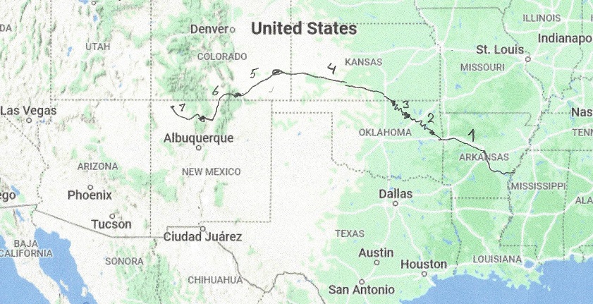
What follows is a description of each leg of the aqueduct. Legs 3, 4, 5 and 6 ends in a dam, which holds enough water to make each leg free to operate to best use of available electricity and provide peak power on demand.
Leg 1 of The Trans-Rocky-Mountain aqueduct. From the Mississippi river to Webbers Falls lock and dam. Total length 15miles of aqueduct and 335 miles of river. Cost of water 333 kWh per acre-ft.
Leg 2 of The Trans-Rocky-Mountain aqueduct. From Webbers Falls to Keystone Dam, a distance of about 75 miles that is river and 25 miles, which is canal. Cost of water 593 kWh per acre-ft.
Leg 3 of the Trans-Rocky-Mountain aqueduct. From Keystone Dam to Kaw Dam.The Keystone Lake is 38 miles long and the river part is about 110 miles. Cost of water 901 kWh per acre-ft.
Leg 4 of the Trans-Rocky-Mountain aqueduct. From Kaw Lake to John Martin Reservoir, a distance of about 200 miles. Cost of water 4,446 kWh per acre-ft.
Leg 5 of the Trans-Rocky-Mountain aqueduct. From John Martin Reservoir to Trinidad Lake, a distance of about 120 miles. Cost of water 7,300 kWh per acre-ft.
Leg 6 of the Trans-Rocky-Mountain aqueduct. From Trinidad Lake to Abiquiu Reservoir, a distance of 90 miles. Cost of water 7,910 kWh per acre-ft.
Leg 7 of the Trans-Rocky-Mountain aqueduct. From the Abiquiu Reservoir to the San Juan River, a distance of 55 miles. Cost of water 7,395 kWh per acre-ft.
Leg 7 of the Trans-Rocky-Mountain aqueduct. From the Abiquiu Reservoir to the San Juan River, a distance of 55 miles.
Elevation 6270′ Water storage 200,000 acre-ft, max. capacity 1,369,000 acre-ft.
After delivering some water to Rio Grande and other drop off points, the sixth leg has a capacity of 8500 cfs. It starts out at 6270′ and climbs to 7400′ over a distance of 25 miles. This requires a maximum power of (7400-6270 + 2x 25) = 1180′ times 8500 cfs. Assuming a pump efficiency of 92% this comes to a power of 900 MW. From the top it then descends to 5590′ over 30 miles. This will generate a power of (7400-5590 – 2x 30) = 1750′ times 8500 cfs. With generator efficiency of 92% this comes to 1,100 MW. This last leg will generate up to 200 MW power, thus reducing the total power need for the aqueduct.
Once joining the San Juan River there may be some levies put in to protect the people having built their homes in the flood plain. The river once was unregulated and subject to seasonal floods, and periods of very low flood, but once the San Juan Reservoir was built, the ecology of the river changed drastically. The addition of the aqueduct’s water would further stabilize the flow, but not add to the risk of seasonal floods.
The San Juan River would then add a maximum of 8,500 cfs. of water to the Colorado River, but especially during the summer months much water will be delivered en route to thirsty communities, such as Albuquerque and even Santa Fé, and some water will help the greening of the surroundings of the aqueduct and even save aquifers, especially the Ogallala aquifer, so the real average flow will be more like 5,000 cfs. This will translate to an additional yearly inflow of 3.6 million acre-feet into the Colorado River.
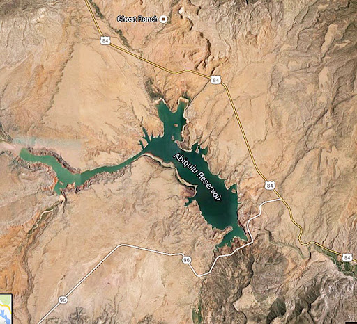
Leg 6 of the Trans-Rocky-Mountain aqueduct. From Trinidad Lake to Abiquiu Reservoir, a distance of 90 miles.
Lake Trinidad, elevation 6230′ Water storage 100,000 acre-ft
From Lake Trinidad the aqueduct will carry up to 10,000 cfs.
Elevation 6270′ Water storage 200,000 acre-ft, max. capacity 1,369,000 acre-ft.
The aqueduct will start at Lake Trinidad and follow the river up to Stonewall, where from an elevation of 8450′ it will tunnel under the Rocky Mountains for 7.5 miles and exit 3 miles s.e. of Chama.
From there it will be finding best way to the Rio Grande Canyon, where a dam with culverts for Rio Grande will be built at an elevation of 7490′. The canyon may or may not be a reservoir, dependent on the wishes of the local community. There will be a provision for supplying Rio Grande with some water during the growth season. On the West side of Rio Grande it will gently descend to 6000′, but with occasional rises of up to 100′ . Finally it will climb 270′ to Abiquiu Lake. There will be a provision to supply the river with water , especially during the dry summer. The total climbs for this leg is (8450 – 6230 + 150 + 270)’, plus the 2feet drop per mile times 25 miles. This comes to 2690′. The power required to pump 10,000 cfs 2690feet is 2.4 GW, assuming 92% pumping efficiency. Some of the power is regained on the downhill part, Total downhill is (8450 – 6000 + 100)’ = 2550′ minus the 2feet drop per mile times 65 miles. This comes to 2420′ Power regained from 10,000 cfs dropping 2420′ is 1.8 GW assuming 92% generating efficiency. The total power requirement for this leg is 600 MW. This can best be provided by having 6 100MW Liquid Fluoride Thorium Reactors, they are carbon neutral. The reason for small reactors is that they can be built in assembly line fashion and the core reactor can be shipped on a flatbed truck. The reactors will provide power to pump as much water as needed, but will stop pumping water when peak power is needed and start acting as a virtual hydro-storage. For this leg seepage and evaporation losses will be less than 2%.