
The American Southwest has always been subject to drought cycles, some worse than the one that is now devastating the area. Below is a very interesting presentation from ASU about a previous civilization in the Phoenix area, thriving and then gone. https://www.youtube.com/embed/II4Wb8SVxCE?version=3&rel=1&showsearch=0&showinfo=1&iv_load_policy=1&fs=1&hl=en&autohide=2&wmode=transparent Arizona State University presentation
Will it happen again?
The problem:
- Lake Powell and Lake Mead will be emptied in less than 10 years with the current usage pattern. Then what?
- The hydroelectric power from Lake Mead (and Lake Powell) is diminishing as the lakes are emptied.
- the aquifers are drawn down everywhere in the Southwest, but also the Ogallala Aquifer in Colorado and Kansas, and are at risk of being exhausted.
- The Colorado River water is too salty for good irrigation .
- The Colorado river no longer reaches the Gulf of California. Fishing and shrimp harvesting around the Colorado River Delta is no more.
- 40 million people depend on the Colorado River for drinking water. The population is still rising rapidly in the West. Will they have water in the future? Think 20 million future population growth in the next 40 years, people want to move there even with the current water problems.
The solution:
Build a Trans-Rocky-Mountain aqueduct from the Mississippi River to the San Juan River. In the first 391 miles the aqueduct joins the McClellan–Kerr Arkansas River Navigation System by adding the capability of pumping 7,500 cfs of water through 16 dams that service the locks. This will lead to reversing the flow of water during low flow. This also facilitates the navigation channel to be deepened from 9 feet to 12 feet to service fully loaded barges, a step authorized but not funded by Congress. The Arkansas river will then be capable of transporting 8 million acre-ft of water yearly through Arkansas, Oklahoma, Kansas, Colorado and New Mexico, supplying water from the Colorado river to Lake Powell. All that is needed to do in this stage is provide the dams and locks with a number of pumps and pump/generators to accommodate this, at a cost of less than 2 billion dollars. The next phase is pumping up water in the Arkansas river for 185 miles. To accommodate this there will be 17 small control dams built that are closed when normal pumping occurs and open during flood conditions. The cost for this segment, including pumps will be less than 3 billion dollars. The third segment is a 465 mile aqueduct to cross the Rocky Mountains much like the Central Arizona project but this aqueduct will carry three times more water 1.27 times the distance and raise the water four times higher. The original Central Arizona Project cost $4.7 billion in 1980’s money, the aqueduct part of the Trans-Rocky-Mountain aqueduct will cost around $50 Billion in 2021 money applying simple scaling up principles.
Power requirements for the 3 stages are 310 MW for the canal stage, 600MW for the river stage and 6.2 GW for the aqueduct stage. The aqueduct stage can be controlled by the power companies to shut off the pumps and provide 6.4 GW of virtual peak power for up to 5 hours a day on average, and each leg can be controlled individually since they are separated by large dams. There will be 64 one hundred MegaWatt LFTR (Liquid Fluoride salt Thorium Rector) power stations strategically stationed along the waterway providing pumping of water for 19 hours and providing virtual hydro-power output for on average 5 hours. There will also be 910 MW of power needed that is controlled by the river authorities.
The building cost of providing LFTR power should be around $2.50 per Watt of installed energy if a plant is built to manufacture via an assembly line a standardized version of 100 MW LFTR reactor core vessels assemblies capable of being transported on truck to the installation point. The total power cost should then be 16 billion dollars to build, and 5 cents per kWh or about 2.5 billion dollars a year to provide power.
The Mississippi River has a bad reputation for having polluted water, but since the clean water act the water quality has improved drastically. Fecal coli-form bacteria is down by a factor of more than 100, the water is now used all the way down to New Orleans for drinking water after treatment. The lead levels are down by a factor of 1000 or more since 1979. Plastic pollution and pharmaceutical pollution is still a problem, as is the case with most rivers. The Ph is back to around 8 and salt content is negligible. Mississippi water is good for irrigation, and usable for drinking water after treatment. The Arkansas River water quality is pretty good, good enough in Kaw Lake to be used for municipal water supply. Nitrates and phosphates are lower than in most Eastern rivers, Ph is around 8 and coli-bacteria low.
Most hydroelectric pumped storage was installed in the 70’s. Now natural gas plants provide most of the peak power. This aqueduct will add 6.4 GW to the U.S. pumped peak storage if virtual peak storage is included. By being pumped from surplus wind and solar energy as well as nuclear energy it is true “Green power”. Some people like that.
What follows is a description of each leg of the aqueduct. Legs 3, 4, 5 and 6 ends in a dam, which holds enough water to make each leg free to operate to best use of available electricity and provide peak power on demand.
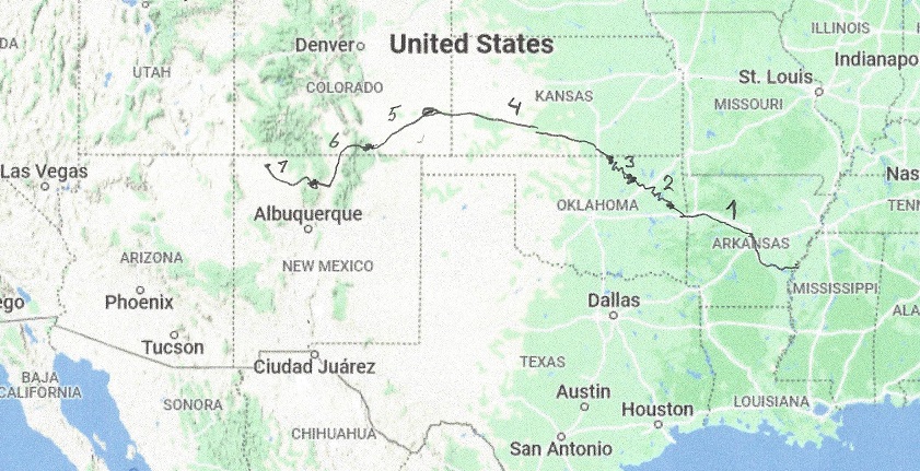
Leg 1 of The Trans-Rocky-Mountain aqueduct. From the Mississippi river to Webbers Falls lock and dam. Total length 15miles of aqueduct and 335 miles of river. Cost of water 333 kWh per acre-ft.
Leg 2 of The Trans-Rocky-Mountain aqueduct. From Webbers Falls to Keystone Dam, a distance of about 75 miles that is river and 25 miles, which is canal. Cost of water 593 kWh per acre-ft.
Leg 3 of the Trans-Rocky-Mountain aqueduct. From Keystone Dam to Kaw Dam.The Keystone Lake is 38 miles long and the river part is about 110 miles. Cost of water 901 kWh per acre-ft.
Leg 4 of the Trans-Rocky-Mountain aqueduct. From Kaw Lake to John Martin Reservoir, a distance of about 200 miles. Cost of water 4,446 kWh per acre-ft.
Leg 5 of the Trans-Rocky-Mountain aqueduct. From John Martin Reservoir to Trinidad Lake, a distance of about 120 miles. Cost of water 7,300 kWh per acre-ft.
Leg 6 of the Trans-Rocky-Mountain aqueduct. From Trinidad Lake to Abiquiu Reservoir, a distance of 90 miles. Cost of water 7,910 kWh per acre-ft.
Leg 7 of the Trans-Rocky-Mountain aqueduct. From the Abiquiu Reservoir to the San Juan River, a distance of 55 miles. Cost of water 7,395 kWh per acre-ft.

from 6 to 7 did you consider TBM , Europe uses for a lot of projects
Sorry, what is TBM ?