When I was a little boy is Sweden my father had a dear old friend that was so in love with birds and they with him that he had a great horned owl that came down and sat on his shoulder when he called. I was only three years old at that time, but the sight of this giant bird coming down from the big spruce tree is a sight I will never forget. Since then I have always enjoyed watching birds, normally soaring hawks, but on occasion eagles, rare as they may be.
Later in life I got gloriously saved and started reading the Bible, and one verse from the prophet Isaiah stands out :Isaiah 40:31 But they that wait upon the Lord shall renew their strength; they shall mount up with wings as eagles; they shall run, and not be weary; and they shall walk, and not faint.
I am now at the stage in my life where walk and not faint seems pretty good, but follow what goes on in the world is still exciting, even watching the birds. They inspire and soar effortlessly, seemingly defy limitations.
The big talk is fighting climate change, and the prevailing political belief is that rising CO2 levels is its major cause, so no expense is spared to find renewable energy in the form of wind power, but at what cost?
The Eagle has landed in aerie
on top of a windmill – that’s scary.
Doesn’t know she will die,
whacked right out of the sky
from rotating blades unawary.
The idea of wind farming is to create sustainable energy.
Will the population of eagles and other large birds be sustainable?
Eagles like to build their aeries on top of wind turbines, the highest structure in their territory.
It is estimated that the total bird kill by the year 2030 is going to be 1 million three hundred thousand birds. And that is if the Green New Deal is not implemented.
Is the large bird population sustainable even now?
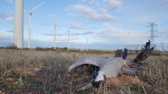
This is a crane killed by a wind turbine blade. In parts of Ohio they have forbidden the turbines to run at night to protect a rare bat.
The allowable yearly limit for killing bald eagles by wind turbines was upped from 1100 to 4200 per year on Jan 17 2017, still under the Obama administration. The allowable limit for golden eagles is still 0. If the bird-kill exceeds the allowance, heavy fines are imposed, but that is just the price of producing clean energy. in 2013 Duke energy paid a 1.9 million dollar fine for killing 14 golden eagles and 149 other protected birds. Recently, a US-based wind energy firm has been slapped with an $8m fine after at least 150 eagles died at its wind farms across eight states over the last 10 years. The company has also been given five years of probation. In April 2022 ESI Energy, a subsidiary of NextEra Energy, did plead guilty to three counts of violating the Migratory Bird Treaty Act. The company acknowledged the deaths of golden and bald eagles since 2012 at its farms in Wyoming, California, New Mexico, North Dakota, Colorado, Michigan, Arizona and Illinois, see more here.
Now for something completely unrelated: If you as a person poaches an eagle egg, see this picture
And it takes energy to produce energy. The cost of de-icing the average airplane is $1500. And that is without a helicopter.
And I am not sure about the former.
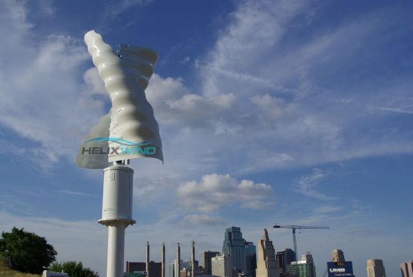
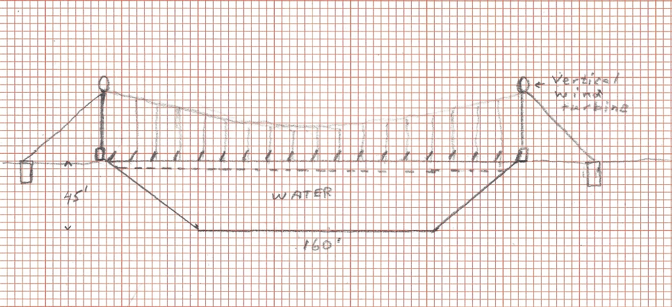
But there is still hope to solve the wind turbine bird kill problem. One potential solution is the vertical wind turbine:
It has a somewhat lower wind efficiency than horizontal, 3 blade wind turbines, but can produce electricity for about 4 c per kWh, about the same as horizontal wind turbines, so all is not lost. They do not kill birds, and can be made to function under wind speeds of up to 70 mph, but cut out speed is typically around 30 mph. This is a rapidly developing field, and requires much further analysis. A typical power output for a vertical wind turbine is 1 to 5 kW, 12 or 24 V output, versus the modern horizontal 3 blade wind turbines are 2 to 4 MW. Yet, the cost per kWh is comparable.
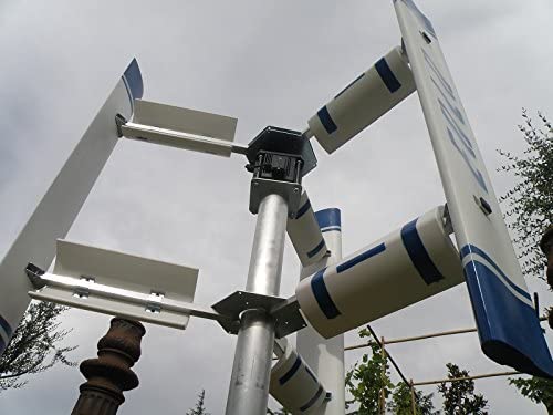
Another design, 300W nominal. Simple. eh!
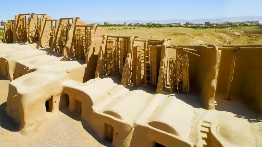
Bur vertical windmills are hardly a new concept. These windmills are from Nashtifan, Iran. Dozens stand atop a wall in the windy city, not far from the Afghanistan border.
From a distance, they look like wooden turnstiles. But they are vertical-axis windmills constructed over 1,000 years ago from wood, straw and clay. And since the blades are arrayed on a vertical axis, energy is translated down the mast to the grindstone without the need for any of the intermediary gears found on horizontal axis windmills.
This local Gazette full page ad caught my attention.
As Christians it is our duty to be at peace with everyone if possible and to leave the world a better place than we found it. I totally agree with the Sierra Club that we need to save our planet (NOW). There are certain things we can do, and other things will happen no matter what we do. One of the latter things is Climate Change. I will answer each of the items and then come up with my suggested solution.
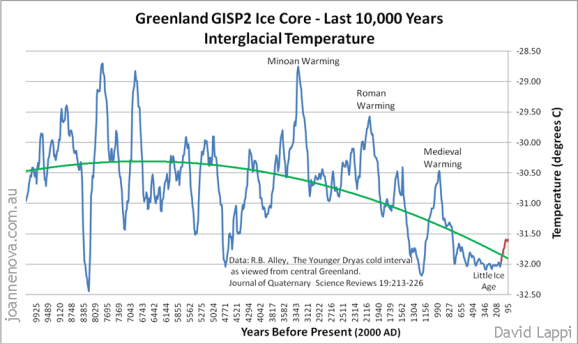
2021 one of the hottest years in human history. This is true, if human history starts with the Little Ice Age 800 years ago, but seen over the last 10,000 years, about 8,500 years were hotter. Long term we are entering into another ice age, which is the normal state of our planet.
As evidence from the Medieval warming is “Gården under sanden,” see here. As evidence from the Roman Warm period, see here
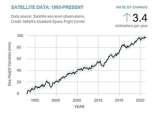
Rising sea level. The sea level rise is very uneven in different parts of the world
Up arrows: sea level rise, down arrows: Land rising
As we can see from the picture, most areas of the world experience sea level rise. In the upper Nordic countries, the Hudson Bay area and Alaska the land rises more than 3 feet per century. The North is still recovering from the last Ice Age. The U,S east coast and the northern Mexican Gulf has the largest sea level rise due to tectonic plate movements, but overall sea level rise is not increasing , and is about one foot per century. Besides the fact that most glaciers are decreasing , we are depleting many vulnerable aquifers, and Lake Aral is no more. All this melting and evaporated water ends up in the ocean.
Desertification. After an Aquifer has been used up and depleted, desertification sets in. The rivers that depend on the same aquifers to form and flow finally dry up. Vegetation wilts and dies, and erosion increases until there are only bedrock and sand left. Like Lake Aral began its demise in the 1970’s so the American Southwest is beginning the process now. One side effect of desertification is that the temperature control from well watered forests and grasslands is gone, and the land starts to experience
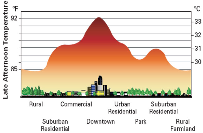
Heat stress. The people that dwell in the downtown deserts experience the so called urban heat island effect where the temperature can be up to 7 degrees Fahrenheit higher than the surrounding rural areas. This figure shows the extent of the effect:
Spread of tropical diseases. America is a land of immigrants. I am an immigrant. When I came to America I had with me a tube containing my chest x-rays, proof of negative Wasserman test and a bunch of other medical records. Upon entry at Kennedy Airport the customs officer opened up the tube, took a good look at the chest x-rays and all the medical and immigration records for about 5 minutes not saying a word, during which time the line behind me grew longer and longer. Then he put everything back in the tube, shook my hand and said: Welcome to America! The people that enter illegally may carry with them all kinds of diseases, such as drug resistant tuberculosis, STDs, and many tropical diseases. People entering legally from the Middle East, South Asia, most of Africa and Middle and South America are given a small dose of ivermectin per protocol.
Drought and flooding. America has a problem. The Eastern U.S.A has frequently too much rain, while the American west for the most part is too dry, made worse by multi year droughts. This is mostly because the mountains go north and south blocking the natural weather flows. Droughts and wildfires are not increasing, despite what we see on TV.
Economic losses. The economic losses from losing much of the water for the dry American South West can barely be calculated. It may eventually be in the trillions of dollars.
Severe Storms. No, storms and tornadoes are not increasing, they are just reported better.
Loss of farmland. Whenever a river dries up or an aquifer is exhausted there will be loss of farmland. Another cause is erosion, depleting the fertile topsoil. This is taking place mostly i the drying American West and South West. In the East there is occasional flood damage. Recuse we have made levees rather than letting the land flood and replenishing the soil with new silt the soil becomes depleted from nourishment.
Mass Extinction. Temperature is not the problem, loss of habitat, invasive species and land use changes are major threats, and must be vigilantly monitored to fight back invasive plants and animals, including bugs, fungi and bacteria. There is a problem with wind power. Wind turbines kill birds, and birds are important for a sustainable environment.
Ocean Acidification. Don’t look at us, look at China.
Refugees. Even if U.S. will successfully close the porous borders, there will still be two to three million legal immigrants per year, some of which have waited up to ten years for their immigration. They need to be resettled, and many prefer the dry South West, putting additional pressure on already strained water resources.
International conflict. It is way above my capability to solve international conflicts, but I can pray to God, that He, through the Holy Spirit will lead us into a worldwide revival and awakening, making us think with a sound mind rather than fall for this global insanity. But, since we are called steward the world and leave the world a better place than we entered it I will propose The TransContinental Aqueduct. A realistic way to save Lake Mead and reverse the desertification of the American South West.
It will, when fully built out provide 12 million Acre-feet of water to the American South West. This will save Lake Mead and also provide up to 50 GW of pumped storage power when fully built up. This power will be provided by an optimal mix of Solar, wind and Liquid Fluoride Thorium power to stabilize the net when the electricity demand increases from switching to electric cars and trucks. California has already had their first warning about charging electric cars.
If we switch all cars to electric power we will have to add 1,100 TWh per year to the electric grid. Electricity generated today is about 4,000 TWh per year. The cars will be recharged partly on peak demand, so the need for peak power will increase dramatically.
The American Southwest has always been subject to drought cycles, some worse than the one that is now devastating the area. Below is a very interesting presentation from ASU about a previous civilization in the Phoenix area, thriving and then gone.
Will it happen again?
The problem:
Lake Mead will be emptied in less than 10 years with the current usage pattern. Then what?
The hydroelectric power from Lake Mead (and Lake Powell) is diminishing as the lakes are emptied.
the aquifers in Arizona, especially in the Phoenix and Tucson area, and to some extent New Mexico and the dry part of Texas are being drawn down and are at risk of being exhausted.
The Salton Sea in the Imperial Valley of California is maybe the most polluted lake in all of U.S.A. It is even dangerous to breathe the air around it sometimes. The area contains maybe the largest Lithium deposit in the world.
The Colorado River water is too salty for good irrigation .
The Colorado river no longer reaches the Gulf of California. Fishing and shrimp harvesting around the Colorado River Delta is no more.
40 million people depend on the Colorado River for drinking water. The population is still rising rapidly in the West. Will they have water in the future?
Except for California there is not much pumped Hydro-power storage in the American Southwest.
Texas has plenty of wind power, but no pumped hydro-power storage. This makes it difficult to provide peak power when the sun doesn’t shine and the wind doesn’t blow. Nuclear power is of no help, it provides base power only. Peak power has to come from coal and natural gas plants.
New Mexico has some ideal spots for solar panels, but no water is available for pumped storage.
Arizona has a surging population, wind and solar power locations are abundant, but no pumped hydro-power storage.
Arkansas and Oklahoma have a good barge traffic system. This proposal will increase flood control and improve barge traffic by increasing the maximum barge draft from 9 feet to 12 feet and during dry periods reverse the flow of the Arkansas River. The Arkansas river yearly water flow is nearly double that of the Colorado River.
The solution:
Build a transcontinental aqueduct from the Mississippi River to the Colorado River capable of transporting 12 million acre-ft of water yearly through Arkansas, Oklahoma, Texas, New Mexico and Arizona. It will be built similar to the Central Arizona Project aqueduct, supplying water from the Colorado river to the Phoenix and Tucson area, but this aqueduct will be carrying four times more water over four times the distance and raise the water nearly twice as high before returning to near sea level. The original Central Arizona Project cost $4.7 billion in 1980’s money, the Transcontinental Aqueduct will in Phase 1 cost around $200 Billion in 2022 money applying simple scaling up principles.
The Mississippi River has a bad reputation for having polluted water, but since the clean water act the water quality has improved drastically. Fecal coli-form bacteria is down by a factor of more than 100, the water is now used all the way down to New Orleans for drinking water after treatment. The lead levels are down by a factor of 1000 or more since 1979. Plastic pollution and pharmaceutical pollution is still a problem, as is the case with most rivers. The Ph is back to around 8 and salt content is negligible. Mississippi water is good for irrigation, and usable for drinking water after treatment. The Arkansas River is used as a drinking water source.
But the aqueduct will do more than provide sweet Mississippi water to the thirsty South-west, it will make possible to provide peak power to Texas, New Mexico and Arizona. In fact, it is so big it will nearly triple the pumped Hydro-power storage for the nation, from 23 GW for 5 hours a day to up to 66 GW when fully built out.
The extra pumped hydro-power storage will come from a number of dams built as part of the aqueduct or adjacent to it. The water will be pumped from surplus wind and solar power generators when available. This will provide up to 50 GW of power for 5 hours a day. If not enough extra power has been generated during the 19 pumping hours, sometimes power will be purchased from the regular grid. The other source of pumped hydro-power storage is virtual. There will be up to 23 GW of LFTR (Liquid Fluoride salt Thorium Rector) power stations strategically stationed along the waterway providing pumping of water for 19 hours and providing virtual hydro-power output for the remaining 5, when the aqueduct is fully built.
These 43 GW of hydro-power capacity will be as follows: Oklahoma, 0.2 GW; Texas, 18,5 GW (right now, Texas has no hydro-power storage, but plenty of wind power); New Mexico, 10.5 GW; Arizona 13.6 GW. In Addition, when the Transcontinental Aqueduct is fully built out, the Hoover dam can provide a true 2.2 GW hydro-power storage by pumping water back from Lake Mojave; a 3 billion dollar existing proposal is waiting to be realized once Lake Mead is saved.
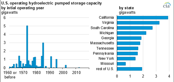
The amount of installed hydroelectric power storage is:
Most hydroelectric pumped storage was installed in the 70’s. Now natural gas plants provide most of the peak power. This aqueduct will more than double, triple the U.S. pumped peak storage if virtual peak storage is included. By being pumped from surplus wind and solar energy as well as nuclear energy it is true “Green power”. Some people like that.
What follows is a description of each leg of the aqueduct. Each leg except legs 9 and 10 ends in a dam, which holds enough water to make each leg free to operate to best use of available electricity and provide peak power on demand.
The Transcontinental Aqueduct will serve the Lower Colorado River Basin, Southern New Mexico and Western Texas. It will pump up to 12 million acre-ft of water annually from the Arkansas river and Mississippi river all the way to southern Colorado River.
The total electricity needed to accomplish this giant endeavor is about 60 billion kWh annually. or about one and a half percent of the current US electricity demand. In 2020 the US produced 1,586 billion kWh from natural gas, 956 from coal, 337.5 from wind and 90.9 from solar.
For this giant project to have any chance of success there has to be something in it to be gained from every state that will be participating. Here are some of the benefits:
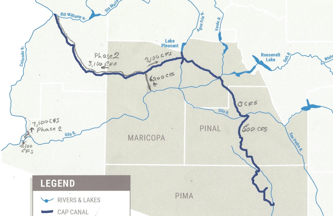
Arizona: Arizona needs more water. The water from Mississippi is less saline and better suited for agriculture and the people growth makes it necessary to provide more water sources. Right now the aquifers are being depleted. Then what? One example: The San Carlos lake is nearly dry half the time and almost never filled to capacity. With the aqueduct supplying water it can be filled to 80 +- 20% of full capacity all the time. In the event of a very large snow melt the lake level can be reduced in advance to accommodate the extra flow. Likewise during Monsoon season the aqueduct flow can be reduced in anticipation of large rain events. Arizona together with New Mexico has the best locations for solar power, but is lacking the water necessary for hydro-power storage. This proposal will give 600 cfs of water to Tucson, 3,100 cfs to the Phoenix area and 3,900 cfs to the lower Colorado River in Phase 1. I phase 2 it will add 3,100 cfs to Lake Havasu and an extra 4,700 cfs to the lower Colorado River. It will also also add 28 GW of hydro-power storage capable of adding 140 GWh of electric peak power daily when it is fully built out in Phase 3.
Arkansas: The main benefit for Arkansas is better flood control and river control of the Arkansas River and allowing it to deepen the draft for canal barges from 9,5 feet to 12 feet, which is standard on the Mississippi river.
California: The water aqueduct serving Los Angeles will be allowed to use maximum capacity at all times. Additional water resources will be given the greater San Diego area. The Imperial valley will be given sweet Mississippi and Arkansas River water, which will improve agriculture yield. The polluted New River will be cut off at the Mexico border. There will be water allocated to the Salton Sea. There is a proposal to mine the world’s largest Lithium ore, mining the deep brine, rich in Lithium. (about a third of the world supply according to one estimate). This requires water, and as a minimum requirement to allow mining in the Salton Sea the water needs to be cleaned. This requires further investigation, but the area around the Salton Sea is maybe the most unhealthy in the United States. It used to be a great vacation spot.
Mexico: During the negotiations about who was going to get the water in Lake Mead Mexico did not get enough water, so they have been using all remaining water for irrigation, and no water is reaching the ocean anymore. In addition the water is too salty for ideal irrigation. This proposal will provide sweet Mississippi and Arkansas River water to Mexico, ensure that some water reaches the Colorado river delta. This will restore the important ecology and restore aquatic life in the delta and the gulf. The town of Mexicali will get some water in exchange for shutting off New River completely.
Nevada: Las Vegas is a catastrophe waiting to happen unless Lake Mead is saved. With this proposal there will be ample opportunity to make the desert bloom.
New Mexico: The state is ideally suited for solar panels. In addition to give much needed water to communities along the length of the aqueduct, it will provide 13.5 GW of pumped storage power to be made available at peak power usage for up to 5 hours a day.
Oklahoma: The main advantage for Oklahoma is a much improved flood control. It will provide the same advantage for river barge traffic as benefits Arkansas.
Texas: The state has a big problem. It has already built up too much wind power and can not give up their coal burning power plants until the electricity is better balanced. They have no hydro-electric power storage at all, and we saw the result of that in a previous year’s cold snap. This proposal will give the Texas electric grid 8.8 GW of hydro-electric power for up to 5 hours a day.
Utah: The state will no longer be bound to provide water to Lake Mead, but can use all of its water rights for Utah, especially the Salt Lake City region.
Wyoming: The state will be free to use the water in the Green River and all the yearly allocated 1.05 million acre-feet of water can be used by the state of Wyoming.
The cost to do all these aqueducts will be substantial, but it can be done for less than 350 billion dollars in 2022 money, and that includes the cost of providing power generation. Considering it involves 40 million people dependent on the Colorado River now and another 10 million east of the Rocky Mountains, it is well worth doing, much more important to do than other “green” projects, since it will save the American Southwest from becoming an uninhabitable desert.
This proposed solution cannot be made possible without changing our approach to power generation. The mantra now is to solve all our power needs through renewables. Texas has shown us that too much wind power without any hydroelectric power storage can lead to disaster. In addition, windmills kill birds, even threatening some species, such as the Golden Eagle and other large raptors that like to build their aeries on top of the generators. Solar panels work best in arid, sunny climate, such as Arizona and New Mexico, but the panels need cooling and cleaning to work best, and that takes water. They are even more dependent on hydro-power storage than wind. The transcontinental aqueduct will triple the hydro-electric power storage for the nation. Without pumped power storage we still need all the conventional power generation capacity for when the sun doesn’t shine and the wind doesn’t blow.
Conventional Nuclear power plants doesn’t work in most places since they depend on water for their cooling, and most of these aqueducts pump water in near deserts, and there would be too much evaporation losses to use water from the aqueducts for cooling.
The only realistic approach would be to use LFTR power plants. (Liquid Fluoride Thorium Reactors). There are many advantages for using LFTR. Here are 30 reasons why LFTRs is by far the best choice.
For this project to succeed there must be developed a better way to build SMRs (Small Modular Reactors, less than 250 MW) more effectively. The price to build a LFTR plant should be less than $2.50 per watt. While the LFTR science is well understood, the LFTR engineering is not fully developed yet, but will be ready in less than 5 years if we get to it. In the mean time there should be built one or more assembly plants that can mass produce LFTR reactor vessels small enough so they can be shipped on a normal flatbed trailer through the normal highway system. My contention is that a 100 MW reactor vessel can be built this way and the total cost per plant will be less than 250 Million dollars. To save the American Southwest we will need about 350 of them, or 87,5 billion dollars total. This cost is included in the total calculation. There will be many more of these plants produced to produce all the electric power to power all the electric vehicles that are going to be built. This is the way to reduce fossil fuel consumption. Just switching to electric vehicles will not do the trick. The electric energy must come from somewhere. To convert all cars and trucks and with unchanging driving habits will require another 600 GW of generating capacity by 2050, our present “net zero emissions” goal.
To do this project we need cooperation from all states in providing eminent domain access. The Federal government will need to approve LFTR as the preferred Nuclear process and streamline approval process from many years to less than one year.
Some of the power will come from solar panels and wind turbines, which will reduce the need for LFTR’s. One tantalizing idea is to cover the aqueduct with solar panels. This will do many things, it will not take up additional acreage, water needed to keep the panels clean is readily available, and can even be used to cool the solar panels if economically beneficial. The area available is 152 feet times 1100 miles = 1.6 billion square feet, and one square foot of solar panel produces around 1 W, which means covering the aqueduct with solar panels would produce 882 MW of power. It would also reduce evaporation. The second source of energy will be 165,000 5kW vertical wind turbines producing 825 MW when the wind is blowing. The rest of the power will cme from LFTRs. This idea requires further analysis. Here is one possible implementation of the idea:
One of the many problems facing solar farms is that they produce electricity only when the sun shines, which is less than half the time, so for the rest of the time electricity must be provided some other way. Historically peak power demands were provided by pumped storage plant, but very few have been built since the 70’s. Peak power is now supplied by natural gas electric plants, which is for now the most economic solution. If we want to get real about reducing our fossil fuel dependence, pumped storage must be looked at seriously, especially when changing our vehicle fleet from gasoline or diesel fuel to electric power source.
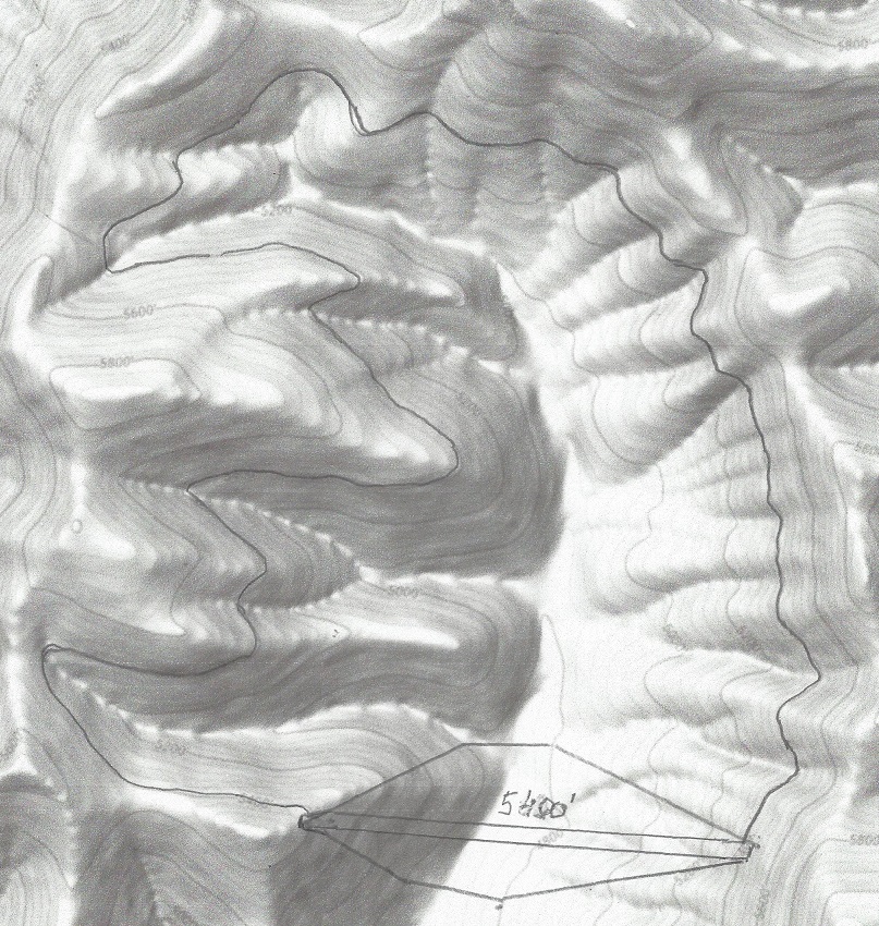
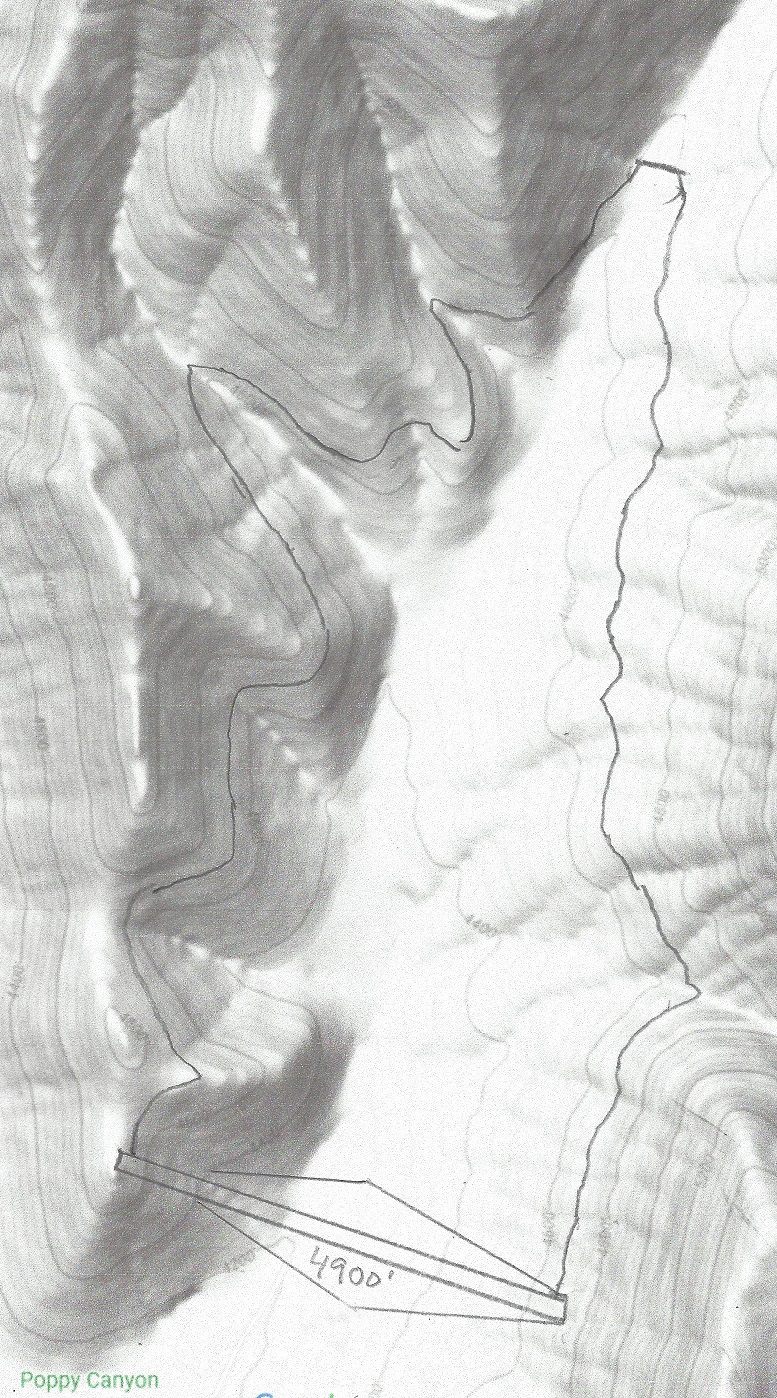
Here is spur 15 proposal sketch
Spur 15 is 7 miles long, starting at 3950′ and ending at 4750′
Dam 1 is the Poppy Canyon Upper Lake. To fill this lake in a year requires Spur 15 to have a capacity of 330 cfs. It will require 240 GWh to fill the lake from the TCA connection point. It has a 4,000 feet wide and up to 640 feet high dam, topping out at 5400 feet, and the lake holds a volume of up to 240,000 acre-ft of water. It would normally hold a minimum volume of 60,000 acre-feet of water to increase the average height difference between the upper and lower dam.
Dam width 4,500′ height 540′ water storage 230,000 acre-ft
Dam 2 dams the Cove Tank dam. It has a 3,300 feet wide and up to 360 feet high dam, topping out at 4,080 feet, and the lake holds a water volume of up to 110,000 acre-ft. Water is pumped from and released to the upper dam via a 13 mile tunnel
Dam width 6,000′ height 380′ water storage 110,000 acre-ft
Dam 3 is the Poppy Canyon Lower Dam. It has a 3,300 feet wide and up to 460 feet high dam, topping out at 4,900 feet, and the lake holds a water volume of up to 70,000 acre-ft. Water is pumped from and released to the upper lake 1.8 mile tunnel.
How much energy will it generate per day? To dam 2 will be releasde 110,000 acre-ft for 5 hrs generating 115 GWh per day or 23 GW of peak power for 5 hrs. Dam 3 will release 70,000 acre-ft for 5 hrs generating 25 GWh per day or 5 GW of peak power for 5 hrs. To again fill dam 2 and 3 will require 17 GW of power from the solar panels. An alternate power would be 9 GW of LFTR power plants, generating 9 GW of alternate peak power when water is released. Most probably the power sources will be a combination of the two.
This pumped storage plant will add another 120% to the existing U.S. pumped storage capacity.
One of the many problems facing solar farms is that they produce electricity only when the sun shines, which is less than half the time, so for the rest of the time electricity must be provided some other way. Historically peak power demands were provided by pumped storage plant, but very few have been built since the 70’s. Peak power is now supplied by natural gas electric plants, which is for now the most economic solution. If we want to get real about reducing our fossil fuel dependence, pumped storage must be looked at seriously, especially when changing our vehicle fleet from gasoline or diesel fuel to electric power source.
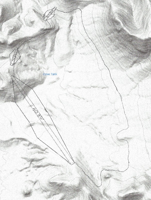
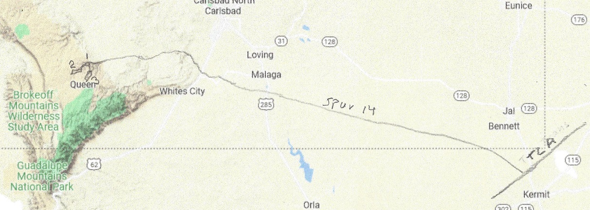
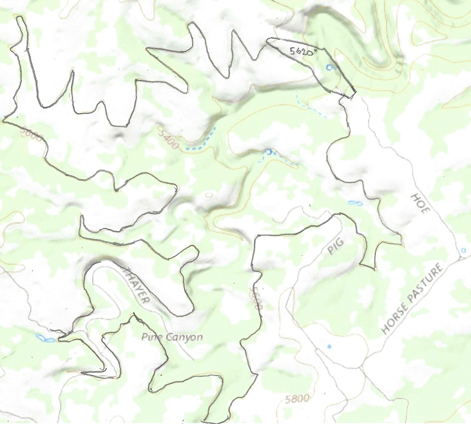
Here is spur 14 proposal sketch
Spur 14 is 100 miles long, starting at 3000′ and ending at 4700′
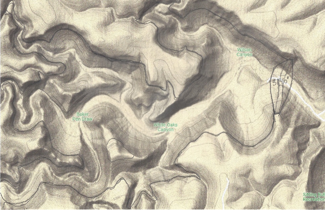
Dam 1 is the White Oaks Canyon Lake. To fill this lake in a year requires Spur 14 to have a capacity of 120 cfs. It will require 190 GWh to fill the lake from the aqueduct.. It has a 2000 feet wide and up to 480 feet high dam, topping out at 5140 feet, and the lake holds a volume of up to 100,000 acre-ft of water.
Dam 2 dams the Pine Canyon dam. It has a 2,200 feet wide and up to 240 feet high dam, topping out at 5,620 feet, and the lake holds a water volume of up to 60,000 acre-ft. Water is pumped from and released to the White Oaks Canyon lake to the Pine Canyon pumped storage via a 2 mile tunnel.
Dam 3 dams the Sitting Bull Canyon well above the Sitting Bull Falls recreation area. It has a 2,000 feet wide and up to 360 feet high dam, topping out at 5,610 feet, and the lake holds a water volume of up to 40,000 acre-ft. Water is pumped from and released to the White Oaks Canyon lake to the Pine Canyon pumped storage via a 2.4 mile tunnel.
How much energy will it generate per day? Dam 2 will release 60,000 acre-ft for 5 hrs generating 45 GWh per day or 9 GW of peak power for 5 hrs. Dam 3 will release 40,000 acre-ft for 5 hrs generating 28 GWh per day or 5.6 GW of peak power for 5 hrs. To again fill dam 2 and 3 will require 17 GW of power from the solar panels. An alternate power would be 4.5 GW of LFTR power plants, generating 4.5 GW of alternate peak power when water is released.
This pumped storage plant will add another 70% to the U.S. pumped storage capacity.
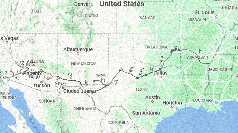
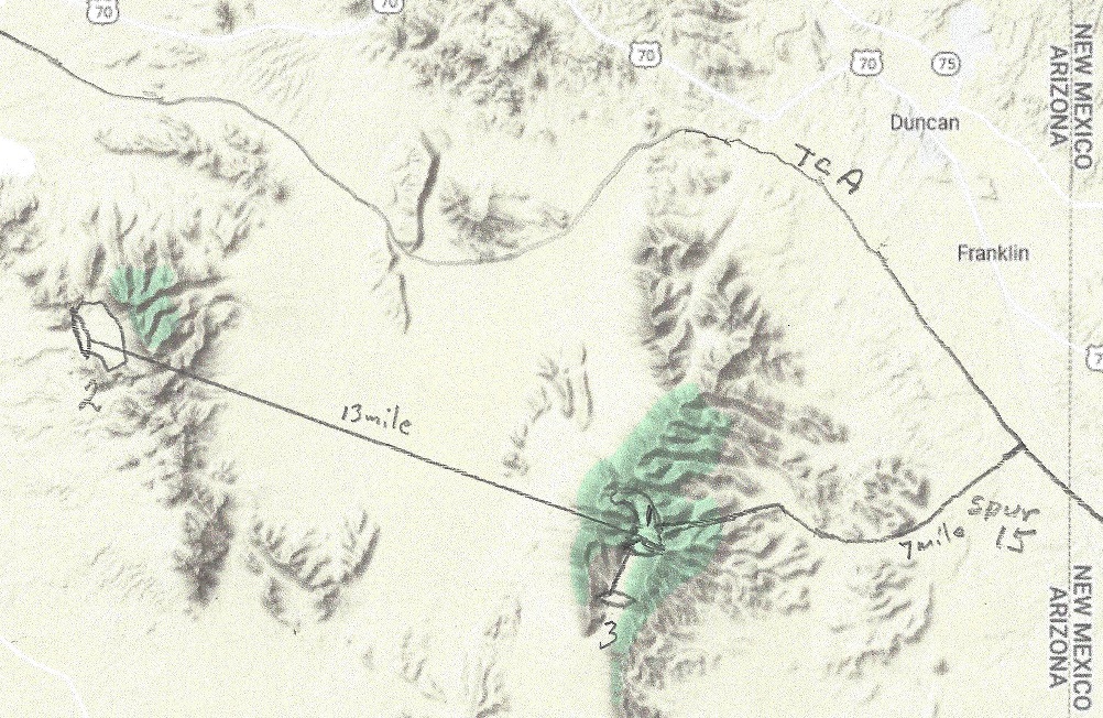
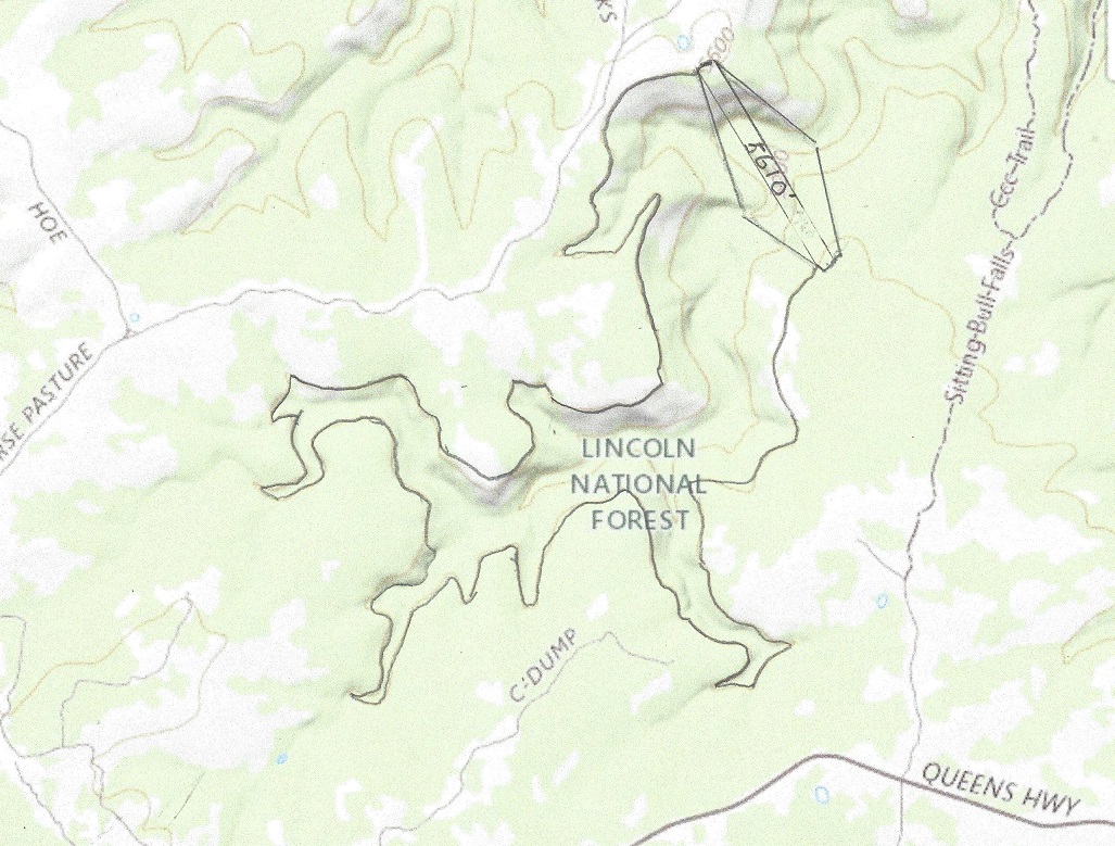
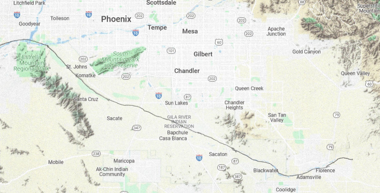
Leg 12 of the Transcontinental aqueduct is complicated. The total length of this segment is 105 miles, 20 miles is a 6,200 cfs aqueduct, and 85 miles is the Gila River. This map may help explain it:
But there is a problem that must be solved. Gila River is now mostly dry, and goes through an Indian reservation. The Gila River used to provide about 1.3 Million Acre-ft per year, snow-melt and monsoon rains providing nearly all of it, but was seasonally dry. Now all the water and then some is spoken for, so the Indians get nothing, and without water you can do no farming, so the reserve is largely depopulated. See map:
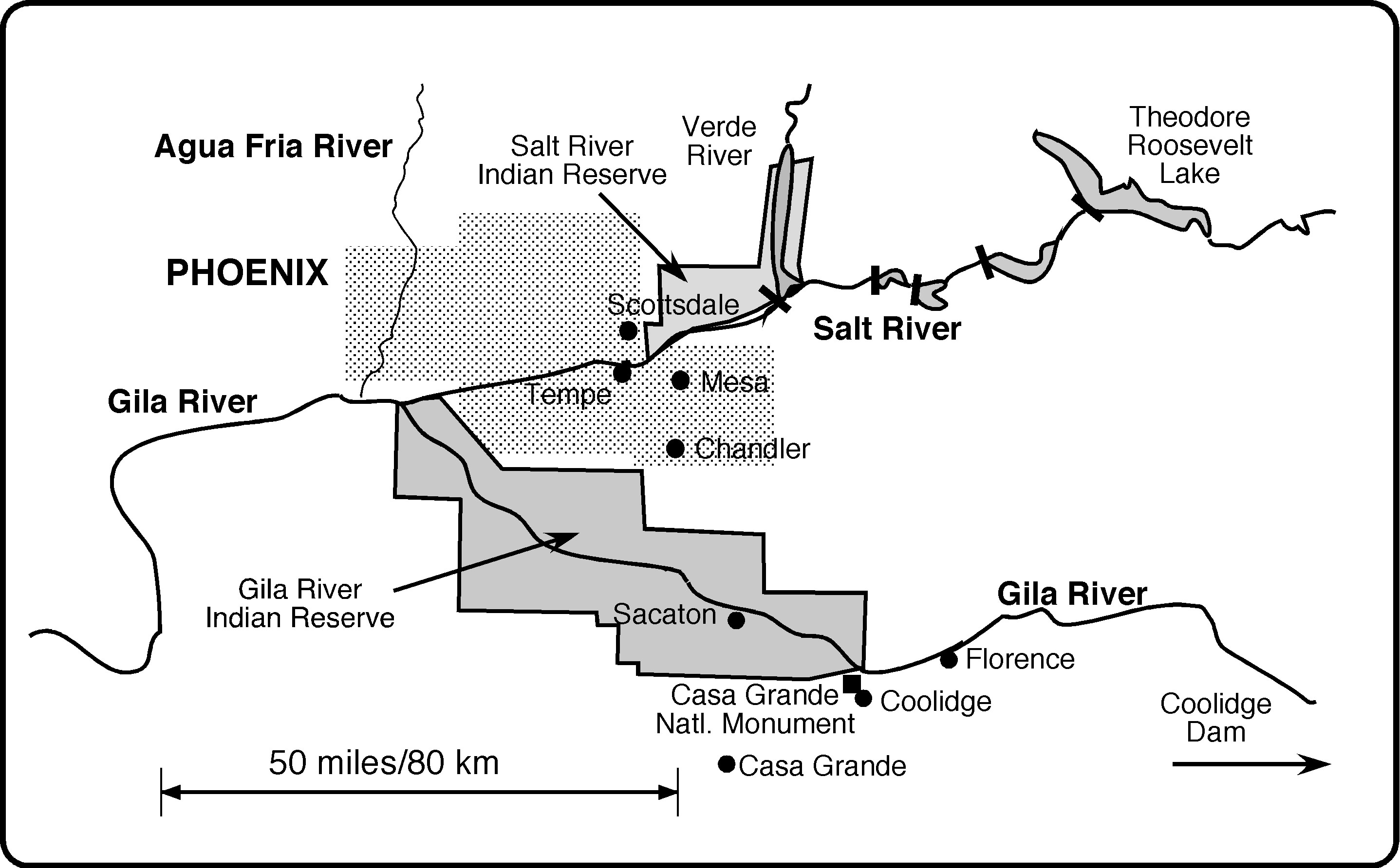
The home of the Gila River Indian Community The Salt and Gila Rivers flow east to west. Present day dams that divert the Salt River into a series of canals are indicated. Roosevelt Dam was completed in 1911, creating Theodore Roosevelt Lake, and Coolidge Dam was completed in 1930. Important locations include the Casa Grande structure, an artifact of the Hohokam times, and the city of Florence, site of the Florence Canal, which is described in the text. The Gila Indians today live on the Reserve shown, with headquarters at Sacaton. The related Salt River Pima-Maricopa Indians live on a separate reserve on the Salt.
In Phase 1, the Gila River will free flow. In Phase 2 there will be a55 mile aqueduct thru the Indian reserve dimensioned for 10,000 cfs flow. It will provide some power with a drop of over 400 feet. The maps will look like this:
Leg 12 east starts out at 1580′ and ends at Arlington Dam, 795′Leg 12 west starts at Arlington dam, 705′ and ends at the CAP canal at 1,380′
Total power required for Leg 12 is 160 MW for phase 1 and 320 MW for Phase 2. Since it is continuous it is best served by three 100 MW LFTR reactors.
In Phase 2 the CAP aqueduct will be replaced by one that flows from east to west, and the Mark Wilmer pumping station will be converted to the Mark Wilmer generating station with the same capacity. Electricity generated will be 16% less than the energy that used to be consumed to pump up the water.
Mark Wilmer PP Aerial
March 29, 2012
Central Arizona Project photo by Philip A. Fortnam
What is in it for Arizona? The Greater Phoenix area will get an increased water supply from the canal,since Tucson is already served in Leg 11. The Gila Indian reserve will get back the water supply that was taken away from them, a way of reparation, and will again make the Gila Indian reserve a viable community.
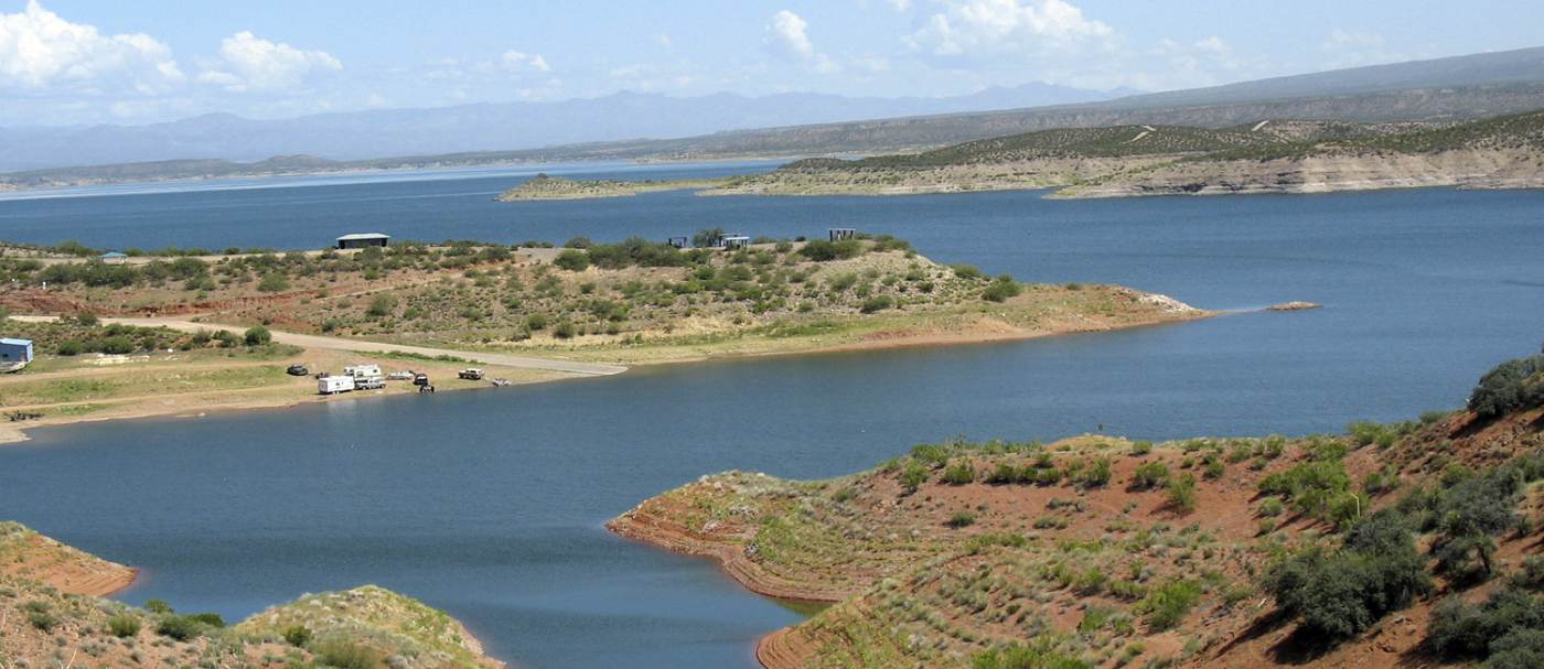
Stage 11 is a true delivery of water on demand aqueduct. The San Carlos lake has a storage capacity of a million acre-ft, the ideal buffer from the peak power demand driven uphill stages to the major delivery stage. San Carlos lake is now mostly empty, but will be normally filled to 85% of capacity, slightly less in advance of the winter snow melt. The Lake would look like this:
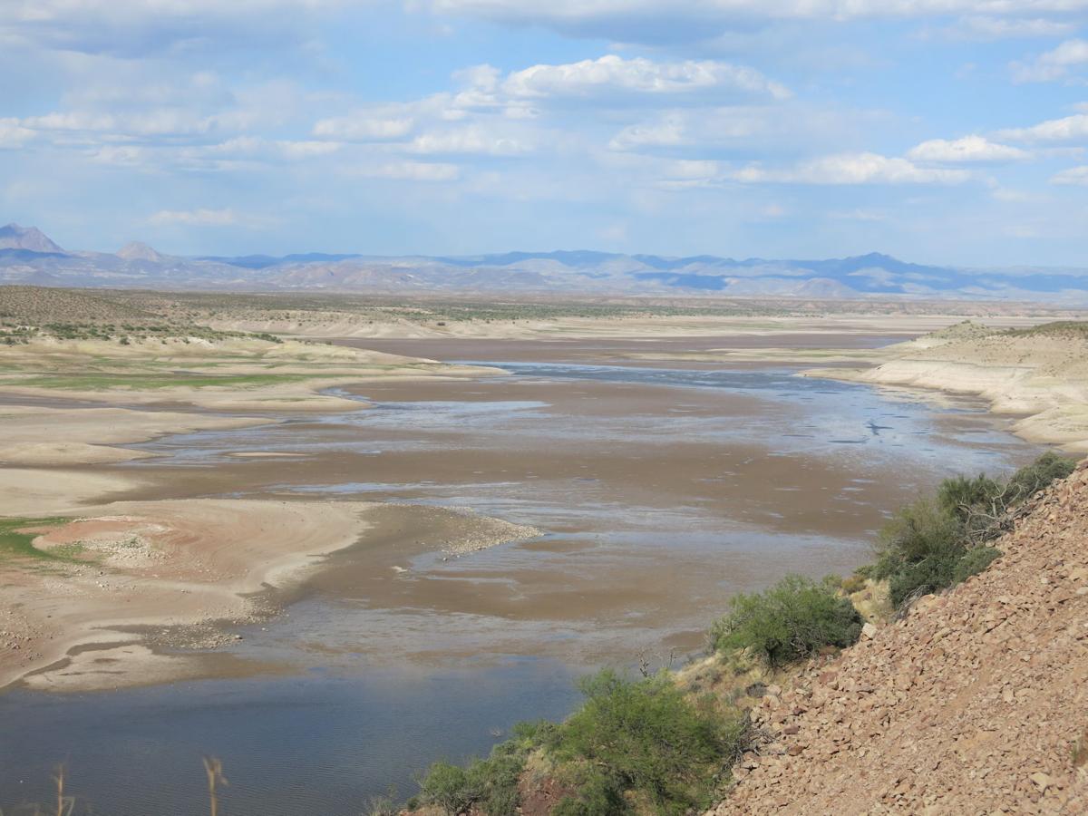
San Carlos lake, about half full
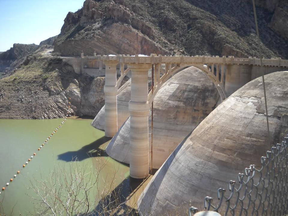
The Coolidge dam is now decommissioned, the lake is too often empty and the dam suffered damage in the power plant and it was no longer economical to produce power. The retrofitted dam will have a power generation capacity of up to 17,000 cfs the top of the dam is at 2535 ft, the typical water level is at 2500 ft and the drop is 215 feet, giving a maximum power output of 275 MW. In the first pass, the maximum output is 8,500 cfs , and the maximum power output is 135 MW.
The Coolidge dam before rebuilding.
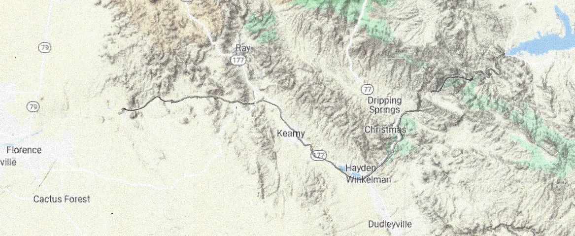
From there the stream follows the Gila River to the East diversion dam and connects to the Tucson leg of the CAP canal, and delivers 600 cfs of water. It it then disconnected to the bottom of the canal.
The East Diversion dam will be reinforced, and the anal capacity will be increased to 600 cfs.The free flowing Gila River with reinforcements around Hayden and the copper mine.
Whats in it for Arizona? Besides having a reliable flow, Gila river will again be good for fishing if stocked and it will deliver 600 cfs of reliable sweet Mississippi and Arkansas river water to the Tucson area. When fully built out it will deliver up to 275 MW of power.
The aqueduct stage of this leg is 32 miles and is generating power.The drop is average (4,200 – 3,000 – 32×2.2) = 1,130 feet. The maximum flow is 16,800 cfs. This stage is capable of generating maximum 1.4 GW of power 24 hours a day. Then it drains into Gila River for 47 miles, following 14 miles of San Carlos lake, for a total of 93 miles.
San_Carlos_Lake is located within the 3,000-square-mile (7,800 km2) San Carlos Apache Indian Reservation, and is thus subject to tribal regulations. It has been full only three times, in 1993 it overflowed the spillway and about 35,000 cfs of water caused erosion damage to natural gas pipelines. The lake contained (April 6,2021) less than 100 acre-ft of water. All fish was dead.
When former President Coolidge dedicated the dam in 1930, the dam had not begun to fill. Humorist Will Rogers looked at the grass in the lake bed, and said, “If this were my dam, I’d mow it.”[
When the Transcontinental aqueduct is built the lake will always be nearly filled, level will be at 2510 feet with flood control nearly automatic, it will never overflow, and it will look like this, or better:
The San Carlos lake, when filled will hold 1,000,000 acre-ft of water. Here it is half filled.
The Coolidge dam will have to be retrofitted to accommodate a 17,000 cfs water flow. When water starts flowing at half capacity, 8,400 cfs in phase 1 of the building project it will take 2 months to fill the lake.
What’s in it for Arizona? The San Carlos Lake has been a great disappointment. It is more often empty than even half full, and when it is empty, all fish die. With The Gila river will be rejuvenated and will be able to carry fish again, making it the great recreation spot it was meant to be. In addition it will generate up to 1,4 GW of Power and carry up to 12 Million Acre-ft per year of water to the thirsty American South-west. In the first phase, while the aqueduct is built to full capacity, when the power stations have installed only half capacity, the flow will be 6 MAf per year, and power generated will be up to 700 MW.
Leg 7 is 255 miles. I starts out at 2700′ elevation and ends at 4500′
Leg 7. from Buffalo soldier Draw upper dam to the highest point in Texas
To lift 17,000 cfs of water (4500 – 2700 + 255×2.2) = 2421 feet with a 92% efficiency requires 3.7 GW of power.
Leg 8 is 125 miles. I starts out at 4500′ elevation and ends at 3800′
Leg 7. from the highest point in Texas to crossing the Rio Grande at La Mesa
To release 17,000 cfs of water (4500 – 3800 – 125×2.2) = 425 feet with a 92% efficiency generates 550 MW of power.
Leg 8 is 125 miles. I starts out at 4,500′ elevation and ends at 3,800′
From La Mesa it will climb to the highest pumping station in Arizona, located 10 miles west of the border, at 4,200 feet. The total lift of the water in stage 10 is (4,200 – 3980 + 160×2.2) feet = 572 ft. To lift 17,000 cubic feet per second 592 feet requires 900 MW of power.
The total power needed for these 3 legs of the Transcontinental aqueduct when fully built up is 4.05 GW of power, the bulk of which will be supplied of 40 100 MW LFTR (Liquid Fluoride Thorium Reactors). They are efficient and carbon neutral.
What’s in it for Texas, New Mexico and Arizona? Up to 17,000 cfs of soft water is being delivered to the thirsty south western states. This corresponds to 12 Million Acre-feet per year. The Colorado river contributes 15 MAF/year. The water delivery in the first pass of implementing the Transcontinental Aqueduct is 6,000 MAF per year.
The aqueduct stage of this leg is 32 miles and is generating power.The drop is average (4,200 – 3,000 – 32×2.2) = 1,130 feet. The maximum flow is 16,800 cfs. This stage is capable of generating maximum 1.4 GW of power 24 hours a day. Then it drains into Gila River for 47 miles, following 14 miles of San Carlos lake, for a total of 93 miles.
San_Carlos_Lake is located within the 3,000-square-mile (7,800 km2) San Carlos Apache Indian Reservation, and is thus subject to tribal regulations. It has been full only three times, in 1993 it overflowed the spillway and about 35,000 cfs of water caused erosion damage to natural gas pipelines. The lake contained (April 6,2021) less than 100 acre-ft of water. All fish was dead.
When former President Coolidge dedicated the dam in 1930, the dam had not begun to fill. Humorist Will Rogers looked at the grass in the lake bed, and said, “If this were my dam, I’d mow it.”[
When the Transcontinental aqueduct is built the lake will always be nearly filled, level will be at 2510 feet with flood control nearly automatic, it will never overflow, and it will look like this, or better:
The San Carlos lake, when filled will hold 1,000,000 acre-ft of water.
The Coolidge dam will have to be retrofitted for a 25,000 cfs water flow
The Coolidge dam will have to be retrofitted for a 17,000 cfs water flow. When water starts flowing at half capacity, 8,400 cfs in phase 1 of the building project it will take 2 months to fill the lake.
What’s in it for Arizona? The San Carlos Lake has been a great disappointment. It is more often empty than even half full, and when it is empty, all fish die. With The Gila river will be rejuvenated and will be able to carry fish again, making it the great recreation spot it was meant to be. In addition it will generate up to 1,4 GW of Power and carry up to 12 Million Acre-ft per year of water to the thirsty American South-west. In the first phase, while the aqueduct is built to full capacity, the flow will be 6 MAf per year.