Dam 1 dams the White Oaks Canyon Lake. It has a 2000 feet wide and up to 400 feet high dam, topping out at 5000 feet, and the lake holds a volume of up to 80,000 acre-ft of water.
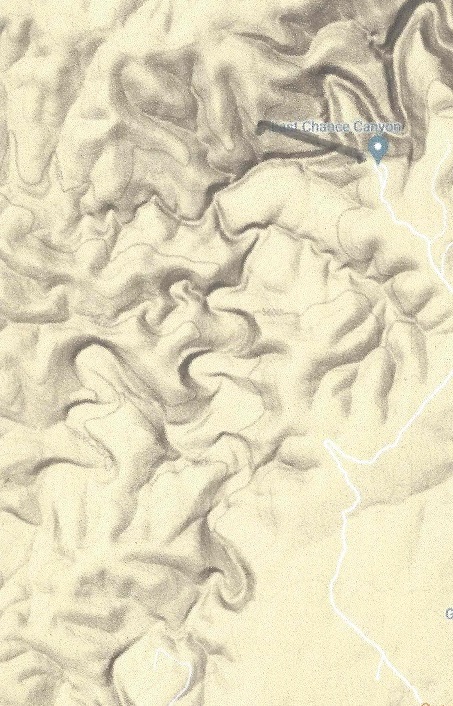
Dam 2 dams the Last Chance Canyon Lake. It has a 2200 feet wide and up to 380 feet high dam, topping out at 5680 feet, and the lake holds a water volume of up to 35,000 acre-ft.
The Stage 7 is a tunnel, starting at 4600 feet and ending at 4492 feet maximum levels. The 20 mile long tunnel will drop 88 feet as it passes under the mountain.
Dam 3 dams the Upper Canyon Lake for lack of a better word. It has a 1600 feet wide and up to 240 feet high dam, topping out at 5200 feet, and the lake holds a volume of up to 15,000 acre-ft of water.
Dam 4 dams the Arch Lewis Canyon Lake for lack of a better word. It has a 3000 feet wide and up to 480 feet high dam, topping out at 4600 feet, and the lake holds a volume of up to 60,000 acre-ft of water.
Up to now all stages have pumped water up the mountains. This stage releases the hydroelectric water storage, and it does so even during peak power, so the water flows all 24 hours with peak electricity creation during peak usage. By now, the average flow is down to 19000 cfs , 24 hours a day. During off peak hours, 19000 cfs flows down the tunnel, the power generated is coming from Dam 1 with a water level of between 4980 feet and 4700 feet with an average of 4940 feet. The maximum output level of the water is 4640 feet, so a drop of 300 feet will generate a minimum of 450 MW of power, or 8.6 GWh/day. Part of this energy will be used to pump up the water to Dam 2 and 3. Dam 2 will pump 13,000 cfs of water from 4630 feet to between 5820 feet ans 5520 feet, (average 5760) for 19 hours, an average lift of 1,060 feet. This required a total of 6.2 GWh of energy per day , or 326 MW pf power. Dam 3 will pump 6,000 cfs of water from 4630 feet to between 5200 feet and 4930 feet, (average 5120) for 19 hours, an average lift of 520 feet. This required a total of 1.4 GWh of energy per day , or 74 MW pf power.
The net electricity generated during 19 off peak hours is 1.0 MW on average. The electricity generated during the 5 peak hours is 49,000 cfs at a drop of 1060 feet, or 1.16 GW, from dam 2. From dam 3 it will be 22,800 cfs at a drop of 520 feet, or 264 MW. From the 2 dams , total electricity is 1.42 GW. Total electricity generated during these 5 hours is 7.12 GWh. This assumes a 97% efficiency of the reversible pumps from Dam 2 and 3. The pumps from Dam 1 are not reversible.
The tunnel capacity between Dam 1 and Dam 2 outlets is 19,000 cfs, between Dam 2 and 3 it is 49,000 cfs, and from Dam 3 to its exit in Dam 4 it is 71,800 cfs.
The fifth stage was from East of Sweetwater dam (to be constructed) to Grassland Canyon Lake (to be made). The sixth stage is big! The aqueduct travels from South of Lubbock, Texas to the Guadaloupe Mountains in New Mexico, a distance of 200 miles.
The elevation at the Grasslands Canyon lake will top out at 2800 feet with maximum water level at 2790 feet. The White Oaks Canyon dam is 400 feet high and will top out at 5000 feet with a maximum water level at 4950 feet. The total lift of the water in stage 5 is (4950 – 2790 + 200×2.2) feet = 2600 ft. To lift 25,000 cubic feet per second 2600 feet requires twelve 500 MW LFTR nuclear reactors, three on the Texas Grid and nine on the Western national grid. The White oaks Canyon Lake will contain about 130,000 Acre-ft of water when full, about three days of storage. For 5 hours per day these twelve reactors used in this stage can provide 6.0 GW of peak power to the grid instead of pumping water, thus acting as a virtual hydroelectric peak power storage. 1.5 GW of this will be used by the Texas Power Grid, and 4.5 GW by the Western U.S. Power grid, and they have to be coordinated.The White Oaks dam will look like this:
The fourth stage was from North of Baird dams (to be constructed) to East of Sweetwater dam (to be constructed
The elevation at the East of Sweetwater dam is 2450 feet. From the East of Sweetwater dam to the Grasslands Canyon Lake the distance is 90 miles . The Grasslands Canyon lake will top out at 2800 feet with maximum water level at 2790 feet. The total lift of the water in stage 5 is (2790 – 2450 + 90×2.2) feet = 538 ft. To lift 26,000 cubic feet per second 538 feet requires two 500 MW LFTR nuclear reactors plus use another 240 MW from the Texas grid. The EGrasslands Canyon Lake will contain about 110,000 Acre-ft when full, more than two days worth of storage. For 5 hours per day these two reactors can provide 1.0 GW of peak power to the grid.
The third stage was from Brad lake to North of Baird dams (to be constructed).
The elevation at the upper North of Baird dam is 1830 feet. From 19.5 miles ENE of Abilene to the East of Sweetwater dam the distance is 60 miles . The East of Sweetwater dam will top out at 2460 feet with maximum water level at 2450 feet. The total lift of the water in stage 4 is (2450 – 1860 + 50×2.2) feet = 700 ft. To lift 26,000 cubic feet per second 700 feet requires three 500 MW LFTR nuclear reactors plus use another 100 MW from the Texas grid. The East of Sweetwater dam will contain about 100,000 Acre-ft when full, about two days worth of storage. For 5 hours per day these three reactors can provide 1.5 GW of peak power to the grid.
The second stage of the aqueduct went from Aquilla Lake to Brad Lake.
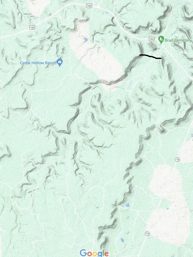
The elevation at Brad lake is 1370 feet. From 25 miles East of Breckenridge the aqueduct goes W to 19.5 miles ENE of Abilene, a distance of 60 miles . The dam yet to be built will top out at 1840 feet with maximum water level at 1830 feet. The total lift of the water in stage 3 is (1830 – 1370 + 60×2.2) feet = 592 ft. To lift 26,000 cubic feet per second 592 feet requires two 500 MW LFTR nuclear reactors plus use another 100 MW from the Texas grid. The upper Brad Cemetary dam will contain about 90,000 Acre-ft when full, about two days worth of storage. For 5 hours per day these two reactors can provide 1 GW of peak power to the grid. There will be a lower dam to provide hydroelectric power storage of 4 GWh, of 800 MW for 5 hours, after which the lower dam will be re-emptied by pumping back the water to the upper dam.
The Deadman Draw upper and lower lake
And this is what a hydroelectric power storage unit looks like:
The first stage of the aqueduct was from the Mississippi river to Lake Aquilla:
The elevation at this lake is 537 feet. From here the aqueduct goes NW to 25 miles East of Breckenridge. The dam is located just south of the Brad Cemetery on U.S. route 180, 25 miles East of Breckenridge. The dam yet to be built will top out at 1380 feet with maximum water level at 1370 feet. The total lift of the water in stage 2 is (1370 – 537 + 100×2.2) feet = 1053 ft. To lift 26,500 cubic feet per second 1053 feet requires four 500 MW LFTR nuclear reactors. Lake Brad will contain about 90,000 Acre-ft when full, about one day’s worth of storage. For 5 hours per day these four reactors can provide 2 GW of peak power to the grid.
The Transcontinental aqueduct at the starting point will have a carrying .capacity of 15 million acre-ft per year, or 21,000 cubic feet per second on average. Maximum flow will be 26,500 cfs, allowing the power generators to supply peak power to the grid for up to 5 hours per day instead of pumping water.
The starting point of the aqueduct is where the Red river empties out in the Atchafalaya river, and has a Mississippi River diversion dam. The elevation at the starting point is 7 feet, and the dam and pumping station will be located in the upper part of the never used Atchafalaya Floodway.
The Mississippi River flood control Morganza spillway is south of the Atchafalaya river diversion, and will not interfere. The place chosen is ideal to relieve some of the Mississippi river flow. Even in the lowest Mississippi flow in a drought year this diversion has sufficient flow to divert 26,500 cfs from it.
The first leg of the aqueduct is 360 miles long and is an open water river with pumping stations whenever the river has to rise about 30 feet. The river runs by gravity until it has sunk about 15 feet which is about 6.18 miles downstream. Since endpoint is at 537 feet elevation this requires about 58 pumping stations. During the course of the path the aqueduct crosses the Sabine River south of the Toledo Bend Reservoir, following the best climb it crosses the Neches River and the Trinity River following the geologically best way until it reaches the Aquilla Lake. The aqueduct is quite substantial, it will carry about 80% more water than the All American canal, seen here under construction. This canal has a drop of about 2.2 feet per mile to accommodate maximum flow.
Pumping 26,500 cfs water through 58 pumping station, each one raising the water about 30 feet requires 4 Gigawatts of power when rounding up for turbine losses. This can be accomplished by eight 500 MW LFTR reactors, also being able to provide up to 4 GW of peak power for 5 hours/day on demand. Two will serve the eastern power grid and six will serve the Texas electrical grid.
The end point for stage 1 of the channel is Aquilla lake, elevation 537 feet. It has a storage capacity of 50,000 acre-ft, which is only half a day’s worth of storage, so Stage 1 and Stage 2 will have to be managed as a unit. It is located 20 miles North of Waco, TX.
Every day the news is devastating, depressing and seemingly hopeless. Some turn off the TV news altogether, hoping that ignoring the news will make them feel better. But we are called to be in the world, and it is our duty to leave the world a better place than we found it. To do that we must know what is happening. One way is to follow the Apostle Paul’s advice in Philippians 4:8 “Finally, brothers and sisters, whatever is true, whatever is noble, whatever is right, whatever is pure, whatever is lovely, whatever is admirable—if anything is excellent or praiseworthy—thinkabout such things.” (NIV). Then we find that there is much good happening for which to be thankful..
Here are a few examples: The Covid pandemic is finally diminishing, and we have vaccines and effective treatments avilable. HydroxyChloroQuine together with Zinc and maybe Azithromycine is a cure if taken early in more than 60% of the cases. It is even effective in the later stage of the sicness if taken in much larger doses. Ivermectine plus Zinc is even more effective, over 80% success rate if taken early. These are proven facts, but the media is still bound to promote vaccines as the only solution. Thinking positively, vaccines are good for people over 50, under 50 you are better off with either HCQ or Ivermactine, taken in proper doses of course. An overdose of Tylenol can destroy your kidneys and even cause death, yet it is safe and effective in proper doses. The point of all this is that we have learnt so much during this pandemic for which we should be thankful,.. and the proper treatments should be promoted.
I could go on with climate change. Yes, there is climate change, and this is on balance good. When you want hothouses to yield more, you increase the CO2 level, typically double it. This leads to increased yields. Since CO2 levels have increased, we can now feed 2 billion more people than before, and have fewer people starving. The temperatures in the tropics are not increasing, the control mechanism is clouds, they cool by day and warm by night. The control is so good that just one percent change in cloud cover means more than all the increase in the CO2 levels. One place where God’s temperature control doesn’t work perfectly is in deserts. With no clouds, no temperature control. So w must do what we can to prevent more areas from becoming a desert. One way is to plant more trees. This is especially important to lower temperatures in urban areas with all their roads, houses and parking lots.
My dream is to see built a transcontinental aqueduct from the Mississippi river to the Colorado River. It would save the southwest from becoming a desert, save Lake Mead, double the irrigation in the Imperial Valley and Mexico, water the people of Arizona and New Mexico and provide much needed hydroelectric power storage for the state of Texas. At the moment Texas has none, but they have a lot of wind power and no way to store the energy to use when the wind is not blowing. Arizona and New Mexico would like to have solar power, but they do not have the water to provide hydroelectric power storage. The aqueduct will provide the water for the hydroelectric power storage as the water flows down from the highlands. All it takes is twenty-three Liquid Fluor Thorium nuclear Reactors of 500 Megawatt capacity each to power the aqueduct, so it is very doable. Congress is now disussing an infrastructure bill. If there wver was a project worth their consideration this would be it!
The Hoover dam water is being depleted. We are running out of water in the South-West United States. The water used for irrigation is too salty. The rapidly growing population requires more and more water. Texas needs hydro-electric storage to supplement the power when the wind is not blowing and the sun is not shining.
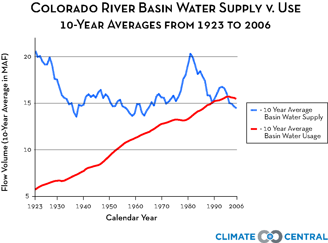
First let us assess the size of the problem. The rainfall reaching the streams in the Colorado River basin is about 15 million acre feet per year, and is not increasing. See figure:
Now let us look at water allocations:
The total allocations come to 16.5 Million Acre Feet per year. This is clearly unsustainable, Lake Mead will be drained by 2 MAF per year and is now at 34% of full pool of 32.3 MAF. If nothing is done it will be drained in 5.5 years. Draining Lake Powell will give us another 4 years, so something must be done in the next 9.5 years.
Texas has a problem, all too well displayed in the big freeze of last winter. The wind farms froze, the sun didn’t shine and the coal fired plants had been shut down for environmental reasons. The only thing that saved the grid from total collapse was Nuclear Power. Even the Natural Gas powered plants ran out of supplies since some pipelines had lost power. And Texas has virtually no hydroelectric storage capacity.
This is my proposal: Build an aqueduct from the Mississippi river to Yuma California, about 1650 miles long, capable of carrying 15 MAF/year of water It will start and end near sea level, and pump water in Texas and New Mexico to more than 4000 feet elevation until it reaches the Gila river near Duncan, NM, then follow the Gila river all the way down to Yuma, AZ. On the way down the Gila River it will generate hydroelectric power, and recover much of the power spent pumping the water upstream in Texas and NM. You may wonder, what would a canal like that look like? Some of the way it would look like this, but be 30% larger, here is the All American canal under construction:
It will have many pumping stations. The size will be about 10 times the capacity of the ones used in the Colorado River aqueduct, shown here. (This aqueduct made it possible for Los Angeles to grow to a megalopolis.)
To pump all this water 4500 feet up will require twenty-two 500 MW electric power generators. The ideal power source for this is Liquid Fluor Thorium Reactors that provide power at all times, most of the time they pump water, but about 6 hours a day they stop pumping and provide peak power, thus functioning as a virtual hydroelectric battery. As all nuclear generators they generate no CO2, and LFTRs are so safe they do not require evacuation zones. If the sun doesn’t shine and the wind doesn’t blow, or it is excessively cold or hot, they can even stop pumping water altogether and provide all the power to the grid. With the water on the downhill leg the opposite is true. It releases most of its water during times of high demand, acting as a normal peak water storage generator facility. Since both start and end points of this aqueduct is near sea level, about 90% of the power is recovered in this way except for the water that is diverted at high altitudes.
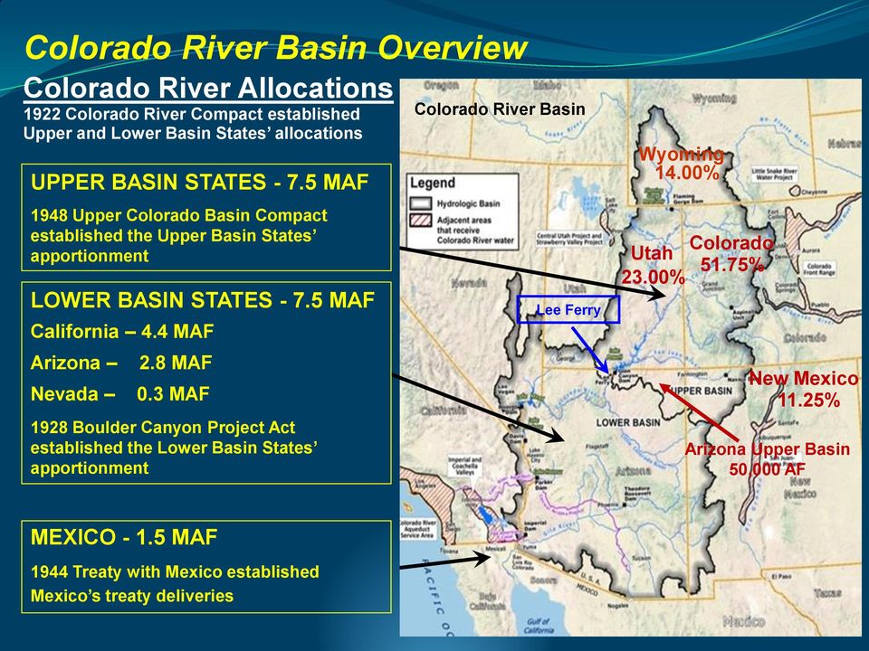
Who is going to get all this extra water? Check the current allotment and the new proposed allotment.
There will be no changes to the allotments for the states in the upper Colorado River basin in this proposal.
California will get its allotment increased from 4.4 MAF to 6.4 MAF, all water coming from the new aqueduct.
Arizona will get its allotment increased from 2.8 MAF to 4.3 MAF, all from the new aqueduct.
Nevada will get its allotment increased from 0.3 MAF to 1.3 MAF, the increase will be taken from Lake Mead.
Mexico will get its allotment doubled, to 3.0 MAF. The Colorado river should again be reaching Baja California with a flow of 0.5 MAF. This may restore a modest fishery.
New Mexico will be allotted 1.0 MAF for high elevation irrigation from this new aquifer.
The aqueduct will supply California, Arizona, New Mexico and Mexico with water from the Mississippi river, much better suited for irrigation than the present water which is high in salinity.
This will reduce the outflow from the Hoover dam by 6.9 MAF, and the new aqueduct will supply 10.4 MAF downstream from Lake Mead.. With this reduction in outflow Lake Mead will recover quite well.
When the Hoover dam is near full pool, we should start using it as a peak power supplier by pumping water back from Lake Mohave to Lake Mead during off peak demand.
If there ever was a project worthy of consideration in the Infrastructure bill, this is it. Look what it does:
Saves Lake Mead from being emptied and secures its refilling over time.
The 22 LFTR plants in Texas and New Mexico will provide up to 8 GW of peak power for 5 hours a day, and all 11 GW of power can be commandeered for emergency use for a week.
The downstream dams in Arizona will provide up to 6 GW of peak power.
Once the project is finished, the Hoover dam is converted to a peak power storage with 2 GW peak power available.
the addition of 10.4 MAF water will add 40% to the water supply for over 40 million people.
The Mississippi water is better suited for irrigation than Colorado River water due to much less salinity.
By increasing irrigation by at least 3.5 MAF it will provide a 40% increase in food production from the greater imperial valley and a 40% increase in food production from Mexico.
The electric energy generated by the Nuclear power plants is all carbon free, and because of the peak power generated on the downhill leg, we can build another 19 GW peak power of renewable wind and solar generators. This will allow us to retire 19 GW of Coal fired power plants once the aqueduct is completed
The new name for this canal would be the Transcontinental Aqueduct.
That ye may be the children of your Father which is in heaven: for he maketh his sun to rise on the evil and on the good, and sendeth rain on the just and on the unjust. Matthew 5:45 (King James version)
The rain that on the righteous falls,
falls also falls also on that other fella.
But mostly on the just, because
the unjust stole the just’s umbrella. (Author unknown)
There is no bad weather, Only bad clothes. (Norwegian saying).
Everybody complains about the weather, but nobody does anything about it. (Common British lament).
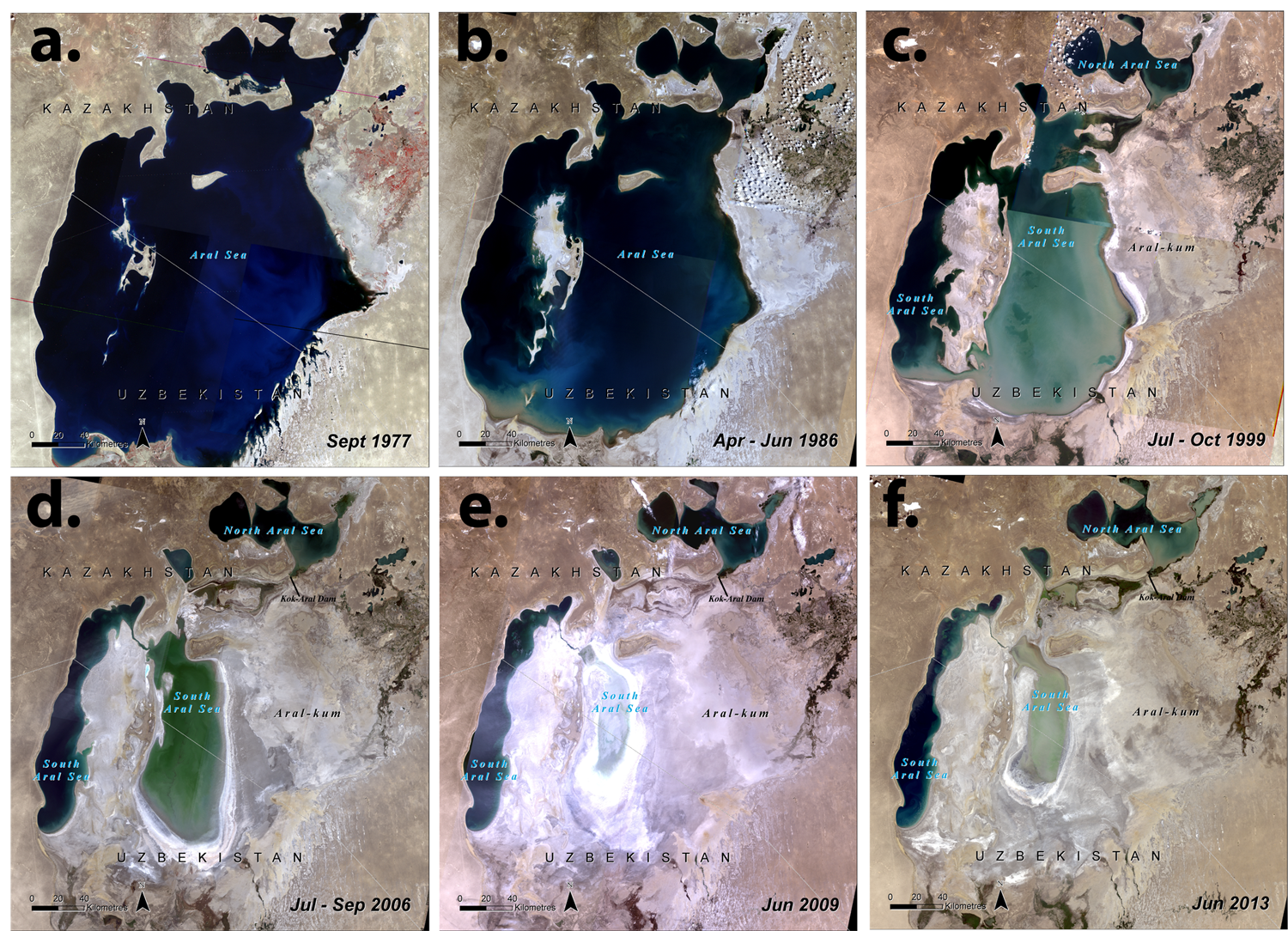
The last comment is not always true. There once was a lake in Central Asia, the fourth largest lake in the world. It provided a sensitive, but functioning Eco-system for a large portion of South East Soviet Union and western Afghanistan. Then the central planners wanted to improve the productivity of the area through central planning on improving land management. In the 1960s and 1970s the Soviets started using the Amu Darya and the Syr Darya rivers to irrigate extensive cotton fields in the Central Asian plain. The results can be seen in these 6 Satellite photos
Disaster is a mild word. The lake was the source of the rains that fell up-stream. With the lake gone, the rivers dried up completely, and the whole upland became desert-like. There has been efforts to restore the upper part of the lake with a dam, but that will do nothing to stop the desertification. My suggestion to solve this is to divert the spring floods from the headwaters of the river Ob and tributaries. There is a gap in the mountains less than 600 feet above sea level, so it is very doable.
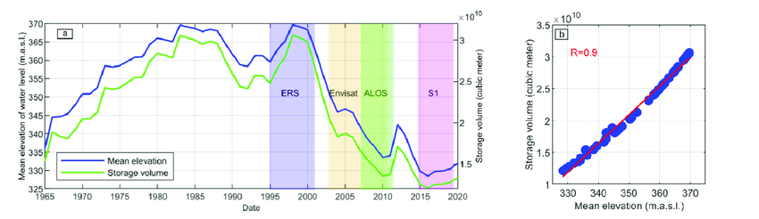
A much bigger challenge is facing the south western United States. Lake Mead is at its lowest point since it was first filled, and Lake Powell is faring even worse, with no spring flood adding to the water storage. lake Mead is at less than 40% of full pool
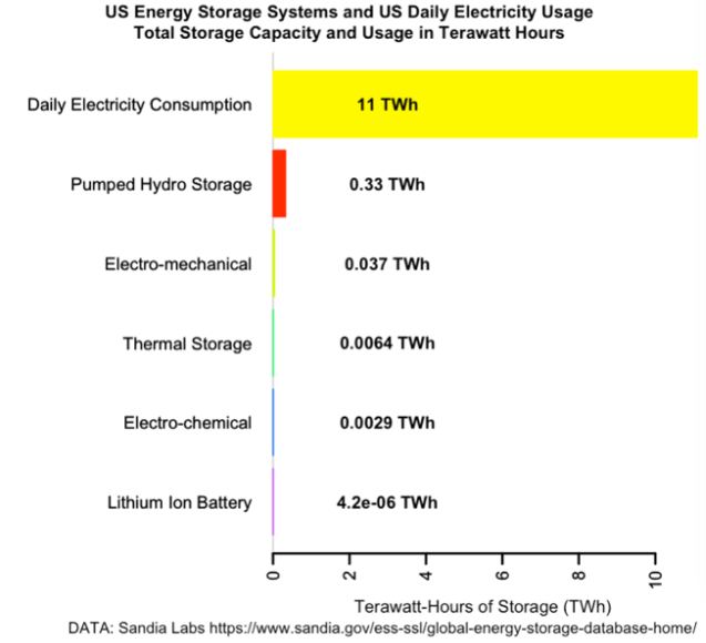
and Lake Powell is at less than 35% of full pool. If nothing is done both lakes will be emptied in less than 20 years, and that is counting on a stable climate. Beside the end of lawns, golf courses, swimming pools and even agricultural irrigation, the dams will no longer provide hydro-electrical storage for peak power, something that is of utmost importance when the wind doesn’t blow and the sun doesn’t shine, which actually happens from time to time. Renewable energy, wind and solar requires a large reserve of stored energy to use as peak power. How much stored energy do we have. This chart is scary:
The lithium batteries we have all over, powering cellphones PCs an all kinds of electric equipment would be able to power the U.s power grid for three hundredths of a second. Large scale electro-chemical storage used by power stations, hospitals and other facilities that need uninterrupted services, also lithium-ion based, can power up the net for almost 23 seconds. And all pumped hydro-electric storage can power the grid for nearly five minutes. This means that nearly all extra peak power up to now has to be provided by Coal and natural gas electric power, since Uranium based nuclear power works as a base load.
There must be a better way to produce electricity. My suggestion will go a long way to provide more water to the Colorado river basin and reduce dependence on fossil fuel.
The Moffat water tunnel takes water from the Colorado river basin, diverts it under the Continental divide and provides some of the water for Denver and Colorado Springs and assorted communities. The yearly water drained from the Colorado river basin is about 74,000 Acre Foot, or about 0.5% of the total rainfall in the Colorado river basin, not much, but every little drop helps. This needs to be stopped. There is one problem, though: The greater Denver- Colorado Springs metropolitan area desperately need more water too, and the Ogalla aquifer is endangered already, so we must do something drastic. The answer is to pump water up-stream South Platte River, all the way from Omaha, Nebraska, lying east of the Ogalla aquifer. To do so we have to pump water 1,300 meter higher, and that requires energy, about 4,500 kWh per acre foot. At a price of 4 cents per kWh that would be about $190 per Acre foot. For an urban dweller or a rancher without water rights it is a bargain, but for a farmer, his water cost would be $250 to $400 per acre, so say the farmer grows corn, this would add $2.60 dollars per bushel in a year without rain at the right time. Any rain during thr growing season would reduce that amount.
The project is very doable and will even allow for increased irrigation, and the draw down of the Ogallala aquifer can stop. We need to pump about 300,000 acre foot per year, requiring 1,35 TWh/year, or about 150 MW of power. But the power stations are only to pump when the electricity demand is low, so it is best to provide 500MW of nuclear power, eliminating maybe 3 TWh/year of coal powered power, reducing CO2 emissions by 3 million metric tons per year. Every little bit helps.
Here is myproposal. Take a maximum of 2000 acre feet of water per day from the Missouri river just south of Omaha, Nebraska, about 3% of the average flow in the river, and pump it up to Colorado Springs, with major tap off stations in Denver and Greely and maybe many other stations. The power will be provided by Liquid Flouoride Nuclear Reactors, maybe five 100 MW reactors. When this project is finished the Moffat tunnel can be shut off, stopping the stealing of water from the Colorado river basin.
Why LFTR? Here is 30 reasons, and the list keeps growing