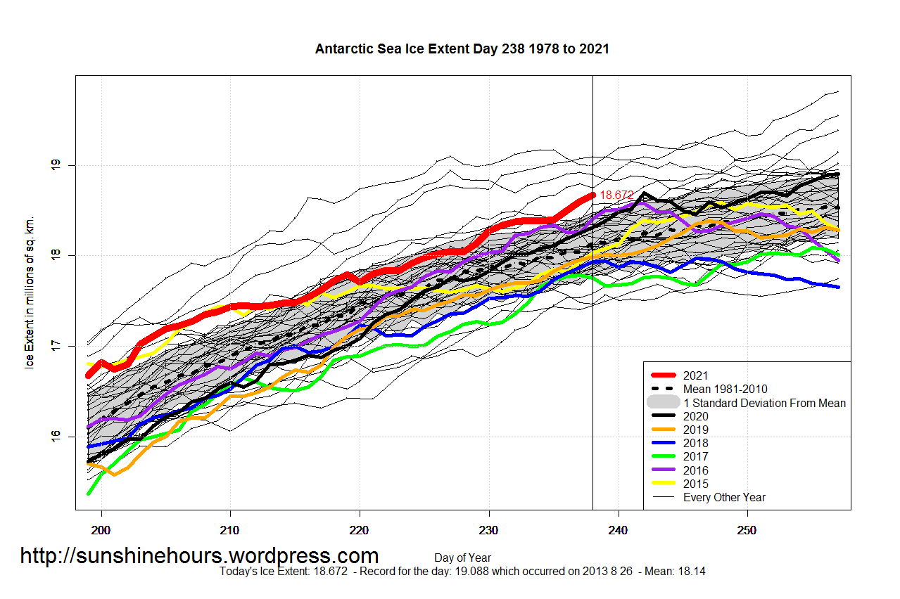
The cooling down in the Antarctic has led to the largest ice sheet in many years for this day. Check the chart: In only four years out of the last 43 has there been more ice.
So, how are the northern polar region shaping up?
The ice in the Arctic will stay
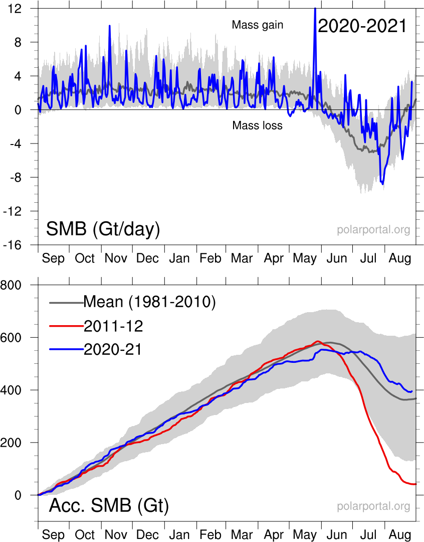
In Greenland it snowed every day
New white snow, what a sight!
Reflects back all the light
No climate change here, this i say.
Back in 2012 the Greenland ice sheet had an unprecedented melt, and the prediction was that all the Arctic ice would be melted in September of 2015, having reached the Climate tipping point from which there is no return to a normal climate unless we reorganized the whole planet into a new totalitarian global governance society.
Well, the tipping point didn’t happen, so hopefully global governance will not happen either, even though many are trying.
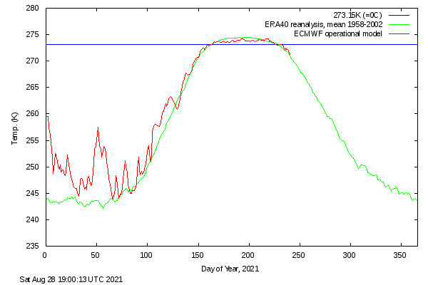
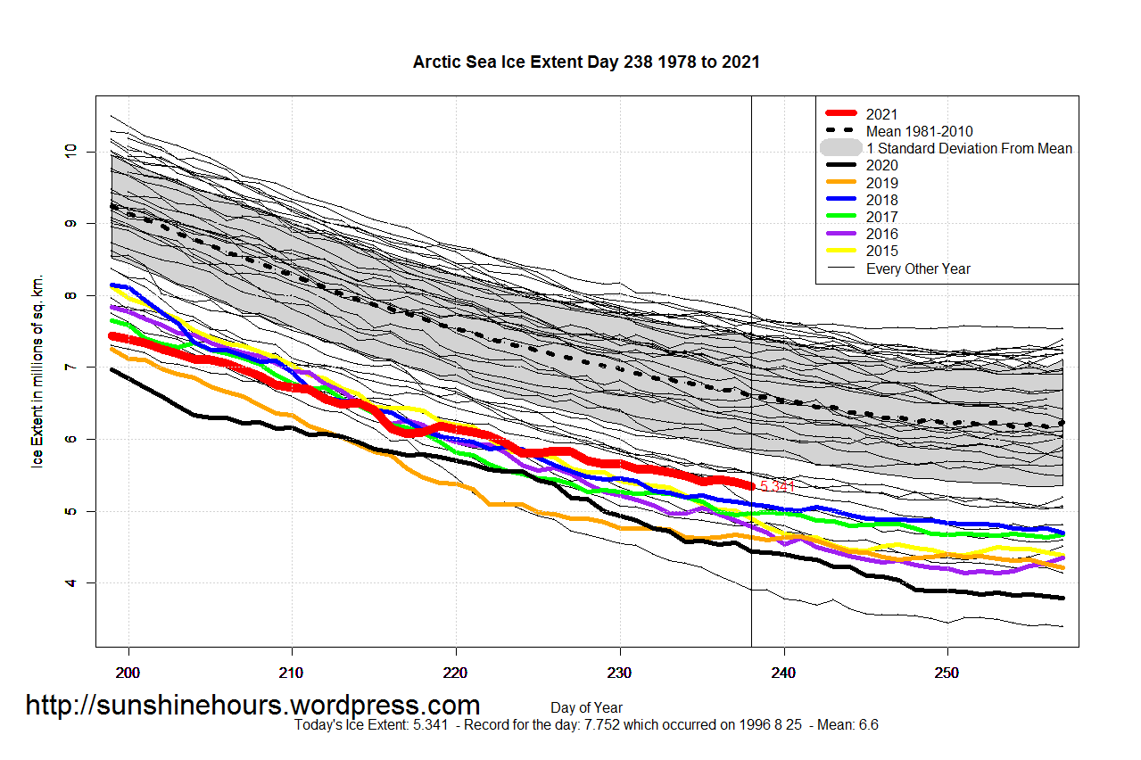
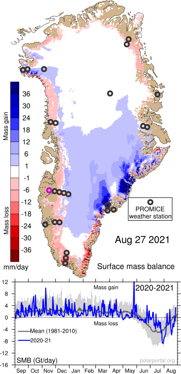
These are the latest charts for arctic temperatures, ice and snow for August 26:
While still below average, it is the most ice for this day in the last ten years.
The ice-pack on Greenland has been melting much less than normal during the melting season
And yesterday’s snowfall over Greenland
Remember, H2O is a condensing gas, when cooled off it condenses into clouds. Clouds sometimes gives rain, and without rain life on land will cease to exist. In the Arctic, instead of rain it snows all times of the year, especially in Greenland. It rains for a month on the coast, but over 2000 feet it is all snow all the time when there is precipitation.
Clouds cool by day and warm by night, a one percent difference in cloud cover means more than the increase in CO2.
The only place where cloud cooling doesn’t work is in deserts. There is an Arab proverb: “All sunshine makes a desert.” The climate change danger is not more CO2, but making more deserts. The American South-west is in danger of being “desertified” unless we restore the fragile water balance in the region. To solve the problem I am proposing a Transcontinental Aqueduct, from the Mississippi river to the Colorado river, using a lot of power, but also producing a lot of peak power and hydro-power storage facilities on the way, and i so doing tripling tht hydro-power ccapacity of the whole nation.
The American Southwest has always been subject to drought cycles, some worse than the one that is now devastating the area. Below is a very interesting presentation from ASU about a previous civilization in the Phoenix area, thriving and then gone.
Arizona State University presentation
Will it happen again?
The problem:
Lake Mead will be emptied in less than 10 years with the current usage pattern. Then what?
The hydroelectric power from Lake Mead (and Lake Powell) is diminishing as the lakes are emptied.
the aquifers in Arizona, especially in the Phoenix and Tucson area, and to some extent New Mexico and the dry part of Texas are being drawn down and are at risk of being exhausted.
The Salton Sea in the Imperial Valley of California is maybe the most polluted lake in all of U.S.A. It is even dangerous to breathe the air around it sometimes. The area contains maybe the largest Lithium deposit in the world.
The Colorado River water is too salty for good irrigation .
The Colorado river no longer reaches the Gulf of California. Fishing and shrimp harvesting around the Colorado River Delta is no more.
40 million people depend on the Colorado River for drinking water. The population is still rising rapidly in the West. Will they have water in the future?
Except for California there is not much pumped Hydro-power storage in the American Southwest.
Texas has plenty of wind power, but no pumped hydro-power storage. This makes it difficult to provide peak power when the sun doesn’t shine and the wind doesn’t blow. Nuclear power is of no help, it provides base power only. Peak power has to come from coal and natural gas plants.
New Mexico has some ideal spots for solar panels, but no water is available for pumped storage.
Arizona has a surging population, wind and solar power locations are abundant, but no pumped hydro-power storage.
The solution:
Build a transcontinental aqueduct from the Mississippi River to the Colorado River capable of transporting 15 million acre-ft of water yearly through Louisiana, Texas, New Mexico and Arizona. It will be built similar to the Central Arizona Project aqueduct, supplying water from the Colorado river to the Phoenix and Tucson area, but this aqueduct will be carrying seven times more water over five times the distance and raise the water more than twice as high before returning to near sea level. The original Central Arizona Project cost $4.7 billion in 1980’s money, the Transcontinental Aqueduct will cost around $340 Billion in 2021 money applying simple scaling up principles.
The Mississippi River has a bad reputation for having polluted water, but since the clean water act the water quality has improved drastically. Fecal coli-form bacteria is down by a factor of more than 100, the water is now used all the way down to New Orleans for drinking water after treatment. The lead levels are down by a factor of 1000 or more since 1979. Plastic pollution and pharmaceutical pollution is still a problem, as is the case with most rivers. The Ph is back to around 8 and salt content is negligible. Mississippi water is good for irrigation, and usable for drinking water after treatment.
But the aqueduct will do more than provide sweet Mississippi water to the thirsty South-west, it will make possible to provide peak power to Texas, New Mexico and Arizona. In fact, it is so big it will nearly triple the pumped Hydro-power storage for the nation, from 23 GW for 5 hours a day to up to 66 GW.
The extra pumped hydro-power storage will come from a number of dams built as part of the aqueduct or very adjacent to it. The water will be pumped from surplus wind and solar power generators when available. This will provide up to 20 GW of power for 5 hours a day. If not enough extra power has been generated during the 19 pumping hours, sometimes power will be purchased from the regular grid. The other source of pumped hydro-power storage is virtual. There will be more than 230 100 MW LFTR (Liquid Fluoride salt Thorium Rector) power stations strategically stationed along the waterway providing pumping of water for 19 hours and providing virtual hydro-power output.
These 43 GW of hydro-power capacity will be as follows: Louisiana, 0.4 GW; Texas, 18,5 GW (right now, Texas has no hydro-power storage, but plenty of wind power); New Mexico, 10.5 GW; Arizona 13.6 GW. In Addition, when the Transcontinental Aqueduct is fully built out, the Hoover dam can provide a true 2.2 GW hydro-power storage by pumping water back from Lake Mojave; a 3 billion dollar existing proposal is waiting to be realized once Lake Mead is saved.
The amount of installed hydroelectric power storage is:
Most hydroelectric pumped storage was installed in the 70’s. Now natural gas plants provide most of the peak power. This aqueduct will double, triple the U.S. pumped peak storage if virtual peak storage is included. By being pumped from surplus wind and solar energy as well as nuclear energy it is true “Green power”. Some people like that.
What follows is a description of each leg of the aqueduct. Each leg except legs 9 and 10 ends in a dam, which holds enough water to make each leg free to operate to best use of available electricity and provide peak power on demand.
Leg 1: Atchafalaya river (Mississippi river bypass) to Aquilla lake, a distance of 360 miles.
Leg 2: Aquilla lake to Brad reservoir (to be built), a distance of 100 miles.
Leg 3: Brad reservoir to North of Baird dams. (to be constructed), a distance of 60 miles
Leg 4: North of Baird dams (to be constructed) to East of Sweetwater dam (to be built), a distance of 60 miles.
Leg 5: East of Sweetwater dam (to be constructed) to Grassland Canyon Lake (to be made), a distance of 50 miles.
Leg 6: Grassland Canyon Lake (to be made) to White Oaks Canyon Lake (to be made), a distance of 110 miles.
Leg 7: White Oaks Canyon Lake (to be made) to the Arch Lewis Canyon Lake via a 20 mile tunnel under the Guadaloupe Mountains in New Mexico.
Leg 8: Arch Lewis Canyon Lake to Martin Tank Lake, a distance of 50 miles.
Leg 9: Martin Tank Lake to Poppy Canyon Reservoir, a distance of 210 miles.
Leg 10: The Poppy Canyon Upper and Lower Reservoir. A Hydro-power storage peak power plant.
Leg 10, alternate solution: Poppy Canyon Reservoir to Cove Tank Reservoir, a distance of 13 miles.
Leg 11: Poppy Canyon Reservoir to San Carlos Lake, a distance of 80 miles.
Leg 12: San Carlos Lake to the Colorado river following the Gila river, a distance of 280 miles.