Having a snow day here at State College, and watching the birds feast on theseeds 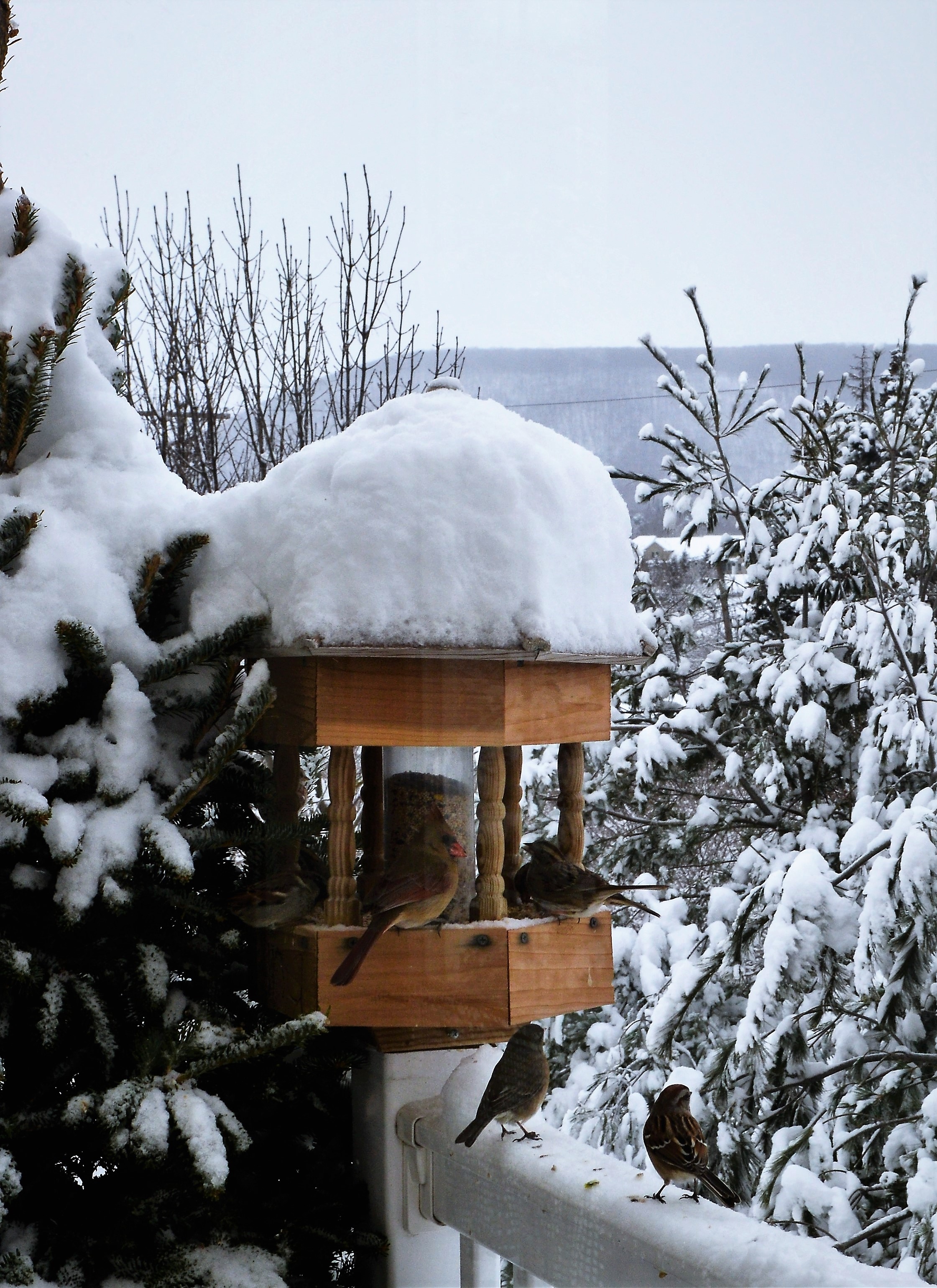 in the feeder, remembering the temperature was in the fifties yesterday my thoughts went back, way back to a time when I was trying to figure out why it was so hard to calibrate a temperature programmed gas chromatograph when analyzing samples from -40C to 275C. During the cryogenic phase water vapor froze on the inside of the oven, and when the oven temperature then rose through the melting point of water, temperature rise took a pause until all the ice was evaporated. As a result, calibration could vary widely dependent on the humidity and how long the oven was in the cryogenic state.
The weather has been unusual this year. After a long drought the Pacific coast has been hit with a seemingly unbroken string of storms, carrying moisture all the way from the Philippines, resulting in record rain and snow. Likewise, in the Atlantic there have been a string of strong storms going from the Gulf of Mexico all the way up to Greenland or Norway, and the storms are still roaring. From time to time the temperature has been reported to be up to 30 degrees warmer than normal, and it has been raining as far north as Svalbard.
A few years ago there was a prediction (was is Al Gore?) that Arctic Sea ice would be totally gone by the year 2015 and the following charts were produced as proof:
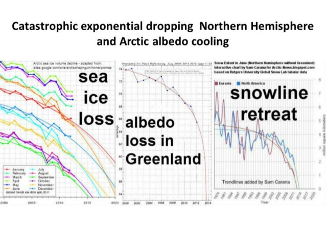 The charts seem to indicate that by September 2015 Arctic ice would be totally gone and all Arctic snow by summer 2014.
Yogi Berra said: “It is hard to predict, especially about the future.” So how are we doing?
Arctic ice started out with the lowest minimum since 2012 and is still at record low levels for this time of the year.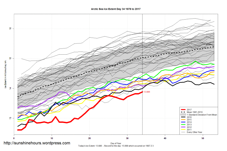
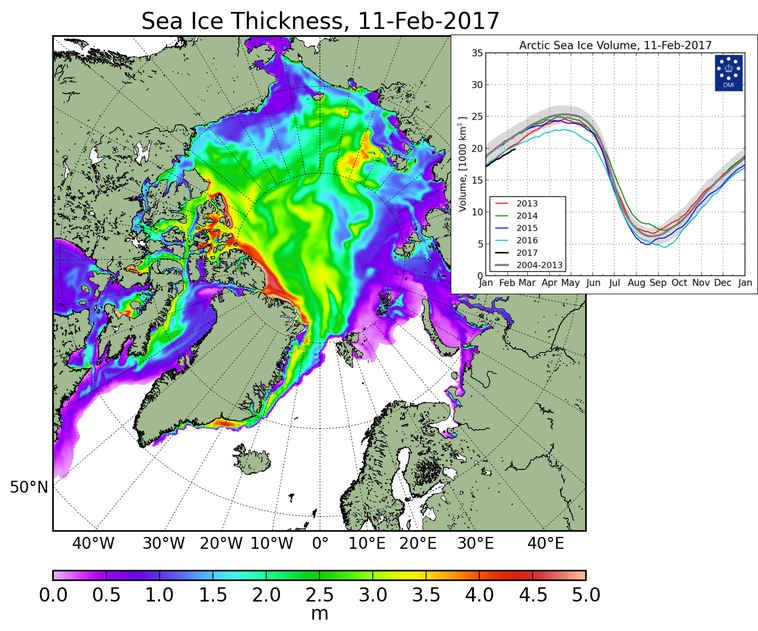
The total sea ice volume is also at a record low for this time of the year: (from DMI, Danish Meteorological Institute)
Couple this with the message that 2016 was reported the warmest year on record, and there seems to be plenty cause for alarm. But then it was reported by whistle blowers that the temperature data is homogenized to better align with climate models, in other words, falsified, so we may have to look for something that does not change over time, like temperature. Snow and ice have the characteristic of freezing and melting at the same temperature, al long as there is no change in what else is in the snow or ice, like soot or salinity.
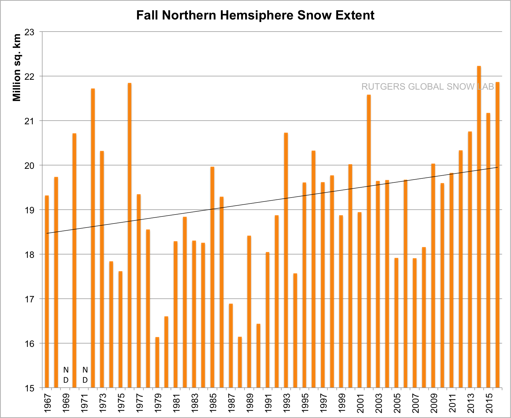 With all this ice melting, what is happening to the snow? Checking Rutgers’ University Global Snow Lab ice charts it is clear that the fall snow cover is increasing, signifying an about 8% increase in the last 50 years, and surprisingly, a significant rise in the last 8 years.
This seems to hint it is getting colder.
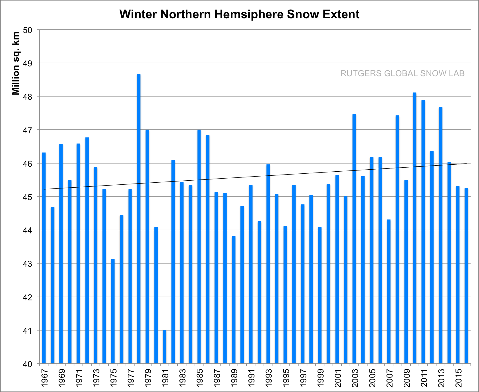 Not so fast: what happens to the winter snow cover?
Again we see a slight upward movement, about 2% in the last 50 years.
The January 2017 result are in, and the snow cover was the 5th highest on record for January, so the upward trend continues, indicating the climate is getting colder.
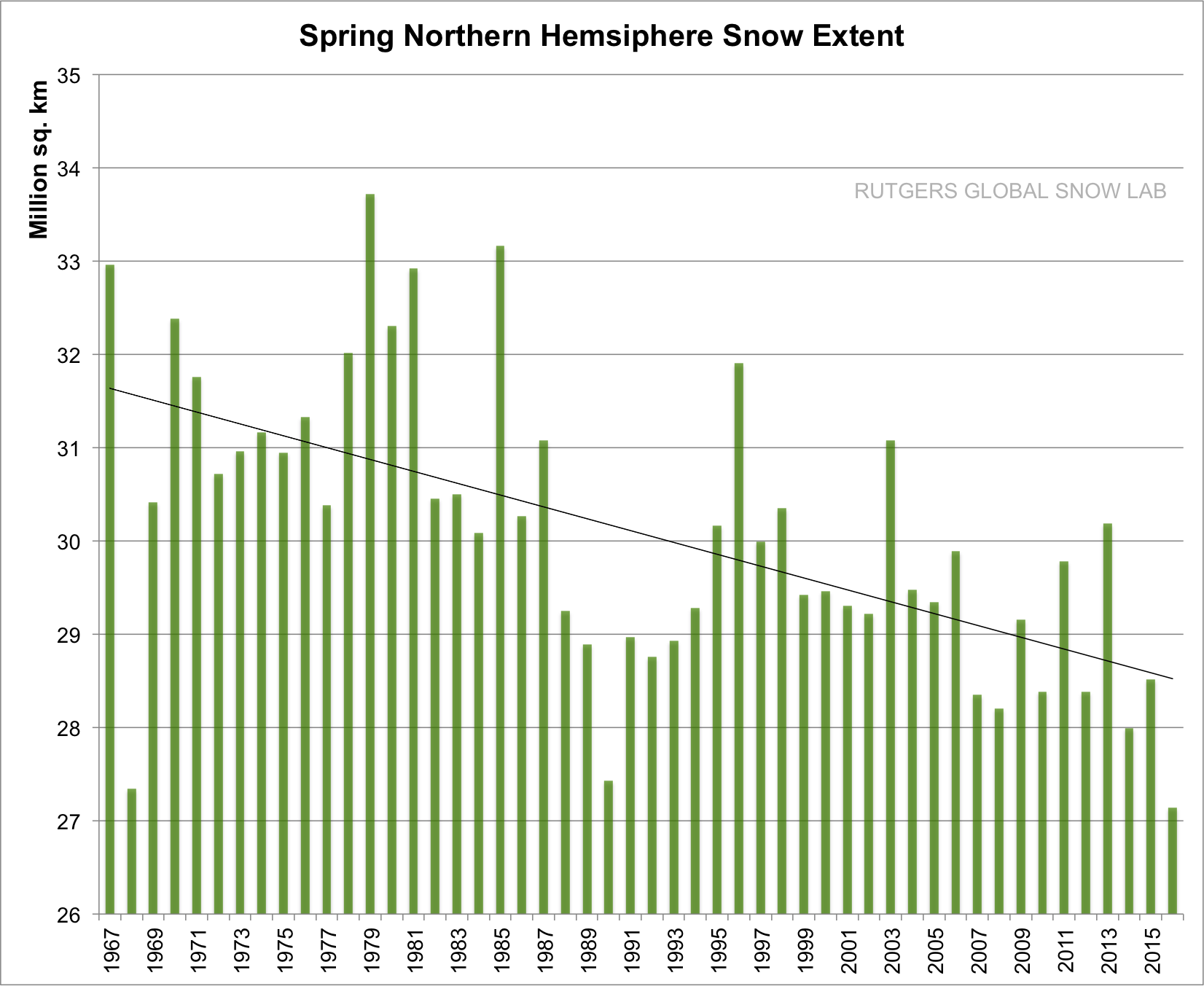 But what happens in spring?
The story is quite different with the snow cover decreasing about 10% in the last 50 years.
That must mean the climate is warming.
Let us look at one more piece of 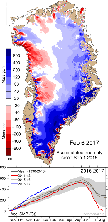 statistics: The Greenland ice cover.
This fall has seen a lot of snow falling over Greenland, about double of normal, much like the rain falling in California, the result of a string of storms starting in the Philippines, raining and snowing i California, snowing out in the Western states, recharging themselves with moisture from the Gulf of Mexico, and finally snowing out over Greenland or Norway.
When the storms hit Greenland the temperature spikes, sometimes reaching 30F above normal, but it is still snowing!
This year the snow fallen over Greenland is larger than ever recorded. This means that al this new-fallen snow will not melt during the melting season, which means the snow albedo is higher this year and will cause less snow melt than in years when the albedo is lower
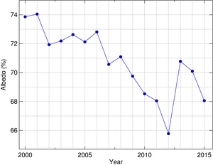 The albedo was constantly getting lower until 2012, and then it again snowed more than normal and the albedo recovered in 2013, from then continuing a downward trend. This year it will probably recover some more, leading to a year of ice gain over Greenland.
Why is the albedo decreasing? Blame China. The last few years they have been building one dirty coal plant every week, spewing out soot and sulphur compounds in spite of their claim to have the best scrubbers. This is the reason for the earlier spring snow melt.
The conclusion?
The effects of increasing CO2 is mush less than the effects from clouds and what the clouds reflect back into the sky and what they carry in the form of water vapor. We are now seeing the result of the end of the el nino, the raining out of the excess humidity, which happens when the earth again is cooling.
The 18 year pause is back, and is now 19 years.
